
|
|
List |
|---|---|
|
|
Preface
This list page forms part of a collection of sub-pages that will support an overarching Area/Range page for the Grampian Mountains in Scotland. Originally the list was intended to be presented on the Area/Range page itself, however, due to the length of the list, and the implications this has to the presentation and load times of the main page, it was decided to remove it from the main body of the work and present it separately.Introduction
The Grampian Mountains are home to many famous and iconic British peaks including such attractions as Ben Nevis, Ben Macdui, Lochnagar and Ben Arthur. This page lists those that qualify to be classified as Corbett.What's a Corbett?
A Corbett is a Scottish hill between 2500 and 2999 feet high with a drop of at least 500 feet (152.4m) on all sides. The main difference between the Corbetts and the Munros is that the definition of a Corbett is much more clearly defined. Much of today’s definition of Munro’s lies with the opinion of the SMC secretary and members and they have refined the list many times, based upon what they think should and should not be a Munro. With Corbett’s however, the only reason for reclassifying a hill is through a more advanced height measurement.
The list was compiled in the 1920s by John Rooke Corbett, a Bristol-based climber and SMC member, and was published posthumously after it was passed to the SMC by his sister. There are 219 Corbetts, 92 of which are located within the Grampian Mountains area.
| How to use this page The Map: The map is interactive and you can get name and height information for the mountains by hovering your mouse cursor over the red triangles. When a little 'hand symbol' appears over a triangle it means that there is a page on Summitpost for that mountain, just click on the triangle to be shown the relevant mountain/rock page. Tip: Look out for these  The Table: This is pretty simple, all you have to do is look at it. The key below explains what the different criteria mean. Key
|
Corbetts of the Grampian Mountains
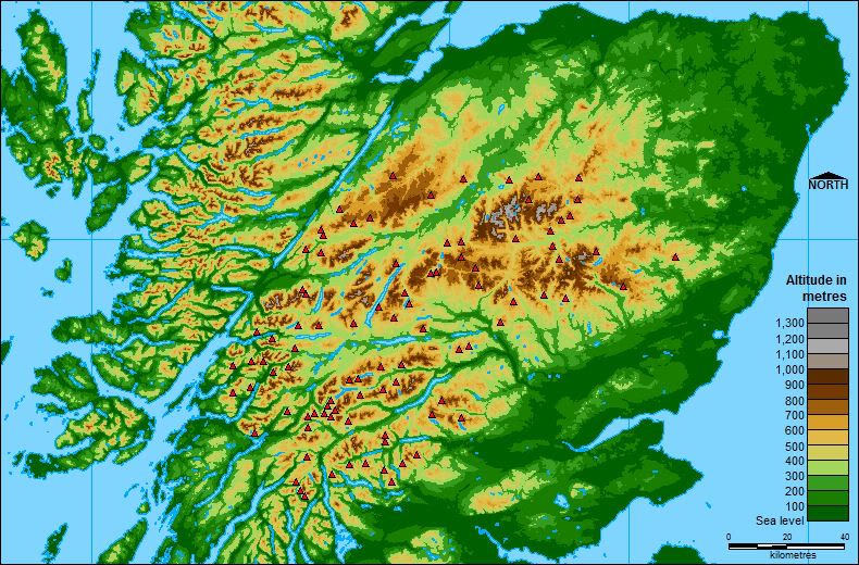 Corbett Map
| Rank | Name | M | Ft | Sec. | Area | Sheet 1:25k | Sheet 1:50k | Grid Ref | Map 1:25k | Map 1:50k |
|---|---|---|---|---|---|---|---|---|---|---|
| =1. | Leathad an Taobhain | 912 | 2992 | 6A | Glen Tromie to Glen Tilt | 394 | 43 | NN821858 |  |  |
| =1. | Beinn Bhreac | 912 | 2992 | 6A | Glen Tromie to Glen Tilt | 394 | 43 | NN868820 | | |
| 3. | The Fara | 911 | 2989 | 4B | Loch Treig to Loch Ericht | 393 | 42 | NN598843 | | |
| 4. | Meall Buidhe | 910 | 2986 | 2A | Loch Rannoch to Glen Lyon | 378 | 51 | NN426449 | | |
| =5. | Leum Uilleim | 909 | 2982 | 4A | Fort William Loch Treig Loch Leven | 385 | 41 | NN330641 | | |
| =5. | Beinn nan Oighreag | 909 | 2982 | 2B | Glen Lyon to Loch Tay | 378 | 51 | NN541412 | | |
| 7. | Beinn Maol Chaluim | 907 | 2976 | 3B | Loch Linnhe to Loch Etive | 384 | 41 | NN135526 | | |
| 8. | Ben Vuirich | 903 | 2963 | 6B | Pitlochry to Braemar | 394 | 43 | NN997699 | | |
| =9. | Beinn Odhar | 901 | 2956 | 2B | Glen Lyon to Loch Tay | 377 | 50 | NN337338 | | |
| =9. | Beinn Mheadhonach | 901 | 2956 | 6A | Glen Tromie to Glen Tilt | 394 | 43 | NN880758 | | |
| 11. | Culardoch | 900 | 2953 | 8B | Cairngorms | 404 | 36/43 | NO193988 | | |
| 12. | Beinn a'Bhuiridh | 897 | 2943 | 3C | Glen Etive to Glen Lochy | 360/377 | 50 | NN094283 | | |
| =13. | Ben Tirran | 896 | 2940 | 7B | Braemar to Montrose | 388 | 44 | NO373746 | | |
| =13. | Gairbeinn | 896 | 2940 | 9B | Monadh Liath | 401 | 34 | NN460985 | | |
| 15. | Creag Mhor | 895 | 2936 | 8B | Cairngorms | 403/404 | 36 | NJ057047 | | |
| 16. | Beinn a'Chuallaich | 892 | 2927 | 5A | Loch Ericht | 386 | 42 | NN684617 | | |
| 17. | Creagan na Beinne | 888 | 2913 | 1A | Loch Tay to Perth | 378 | 51/52 | NN744368 | | |
| 18. | Beinn a'Chaisteil | 886 | 2907 | 2B | Glen Lyon to Loch Tay | 377 | 50 | NN347364 | | |
| =19. | The Cobbler [Ben Arthur] | 884 | 2900 | 1D | Inveraray to Crianlarich | 364 | 56 | NN259058 | | |
| =19. | Cam Chreag | 884 | 2900 | 2B | Glen Lyon to Loch Tay | 377/378 | 50 | NN375346 | | |
| 21. | Stob Dubh | 883 | 2897 | 3C | Glen Etive to Glen Lochy | 384 | 50 | NN166488 | | |
| 22. | Beinn Chuirn | 880 | 2887 | 1D | Inveraray to Crianlarich | 364/377 | 50 | NN280292 | | |
| =23. | Creag Uchdag | 879 | 2884 | 1A | Loch Tay to Perth | 378 | 51/52 | NN708323 | | |
| =23. | Fraochaidh | 879 | 2884 | 3B | Loch Linnhe to Loch Etive | 384 | 41 | NN029517 | | |
| =23. | Ben Ledi | 879 | 2884 | 1C | Loch Lomond to Strathyre | 365 | 57 | NN562097 | | |
| 26. | Carn an Fhreiceadain | 878 | 2881 | 9B | Monadh Liath | 402 | 35 | NH725071 | | |
| 27. | Maol Creag an Loch [A'Chaoirnich] | 875 | 2871 | 6A | Glen Tromie to Glen Tilt | 394 | 42 | NN735807 | | |
| 28. | Stob a'Choin | 869 | 2851 | 1C | Loch Lomond to Strathyre | 364/365 | 56 | NN416159 | | |
| 29. | Meall na Meoig of Beinn Pharlagain | 868 | 2848 | 4B | Loch Treig to Loch Ericht | 385/385 | 42 | NN448641 | | |
| 30. | Garbh Bheinn | 867 | 2844 | 3A | Loch Leven to Rannoch Station | 384 | 41 | NN169600 | | |
| 31. | Conachcraig | 865 | 2838 | 7A | Braemar to Montrose | 388 | 44 | NO279865 | | |
| 32. | Beinn Mhic Chasgaig | 864 | 2835 | 3C | Glen Etive to Glen Lochy | 384 | 41 | NN221501 | | |
| =33. | Carn Liath | 862 | 2828 | 8B | Cairngorms | 404 | 36/43 | NO164976 | | |
| =33. | Cam Chreag | 862 | 2828 | 2A | Loch Rannoch to Glen Lyon | 378 | 51 | NN536491 | | |
| 35. | Meall na h-Aisre | 862 | 2828 | 9B | Monadh Liath | 401 | 35 | NH515000 | | |
| 36. | Morrone | 859 | 2818 | 6B | Pitlochry to Braemar | 387/404 | 43 | NO132886 | | |
| 37. | Beinn Luibhean | 858 | 2815 | 1D | Inveraray to Crianlarich | 363/364 | 56 | NN242079 | | |
| =38. | Cruach Innse | 857 | 2812 | 4A | Fort William Loch Treig Loch Leven | 392 | 41 | NN279763 | | |
| =38. | Beinn a'Chrulaiste | 857 | 2812 | 3A | Loch Leven to Rannoch Station | 384 | 41 | NN246566 | | |
| =38. | Carn Dearg Mor | 857 | 2812 | 6A | Glen Tromie to Glen Tilt | 402 | 35/43 | NN823911 | | |
| 41. | Stob an Aonaich Mhoir | 855 | 2805 | 5A | Loch Ericht | 385/393 | 42 | NN537694 | | |
| 42. | Meall an t-Seallaidh | 852 | 2795 | 1C | Loch Lomond to Strathyre | 365 | 51 | NN542234 | | |
| 43. | Beinn nan Imirean | 849 | 2785 | 2B | Glen Lyon to Loch Tay | 364/378 | 51 | NN419309 | | |
| =44. | Ben Vrackie | 841 | 2759 | 6B | Pitlochry to Braemar | 386 | 43 | NN950632 | | |
| =44. | Beinn Mholach | 841 | 2759 | 5A | Loch Ericht | 385 | 42 | NN587654 | | |
| =46. | Beinn Udlaidh | 840 | 2756 | 3C | Glen Etive to Glen Lochy | 377 | 50 | NN280331 | | |
| =46. | Beinn Trilleachan | 840 | 2756 | 3B | Loch Linnhe to Loch Etive | 377 | 50 | NN086439 | | |
| 48. | Sron a'Choire Chnapanich | 837 | 2746 | 2A | Loch Rannoch to Glen Lyon | 378 | 51 | NN456453 | | |
| =49. | Carn Dearg | 834 | 2736 | 9C | Loch Lochy to Loch Laggan | 400 | 34/41 | NN345887 | | |
| =49. | Creag nan Gabhar | 834 | 2736 | 7A | Braemar to Montrose | 387 | 43 | NO154841 | | |
| 51. | Beinn Dearg | 830 | 2723 | 2A | Loch Rannoch to Glen Lyon | 378/386 | 51 | NN608497 | | |
| 52. | Brown Cow Hill | 829 | 2720 | 8B | Cairngorms | 404 | 36 | NJ221044 | | |
| 53. | An Dun | 827 | 2713 | 5B | Loch Ericht | 394 | 42 | NN717805 | | |
| 54. | Geal-charn Mor | 824 | 2703 | 9B | Monadh Liath | 417 | 35 | NH836123 | | |
| =55. | Geal Charn | 821 | 2694 | 8B | Cairngorms | 404 | 36 | NJ090127 | | |
| =55. | Benvane | 821 | 2694 | 1C | Loch Lomond to Strathyre | 365 | 57 | NN535137 | | |
| =57. | Beinn Chaorach | 818 | 2684 | 2B | Glen Lyon to Loch Tay | 377 | 50 | NN358328 | | |
| =57. | Carn na Drochaide | 818 | 2684 | 8B | Cairngorms | 404 | 36/43 | NO127938 | | |
| =59. | Carn Dearg | 817 | 2680 | 9B | Monadh Liath | 400 | 34 | NN349966 | | |
| =59. | Stob Coire Creagach [Binnein an Fhidhleir] | 817 | 2680 | 1D | Inveraray to Crianlarich | 363/364 | 50/56 | NN230109 | | |
| =59. | Carn a'Chuilinn | 817 | 2680 | 9B | Monadh Liath | 401 | 34 | NH416034 | | |
| =62. | Beinn Each | 813 | 2667 | 1B | Strathyre to Strathallan | 365 | 57 | NN601158 | | |
| =62. | Sgor Mor | 813 | 2667 | 8A | Cairngorms | 387/403 | 43 | NO007914 | | |
| 64. | Carn na Saobhaidhe | 811 | 2661 | 9B | Monadh Liath | 417 | 35 | NH599144 | | |
| =65. | Creach Bheinn | 810 | 2657 | 3B | Loch Linnhe to Loch Etive | 377 | 50 | NN023422 | | |
| =65. | Meall a'Bhuachaille | 810 | 2657 | 8A | Cairngorms | 403 | 36 | NH990115 | | |
| =67. | Sgurr Innse | 809 | 2654 | 4A | Fort William Loch Treig Loch Leven | 392 | 41 | NN290748 | | |
| =67. | Meall na Fearna | 809 | 2654 | 1B | Strathyre to Strathallan | 368 | 57 | NN650186 | | |
| =67. | Creag Mac Ranaich | 809 | 2654 | 1C | Loch Lomond to Strathyre | 365 | 51 | NN545255 | | |
| 70. | Monamenach | 807 | 2648 | 7A | Braemar to Montrose | 387/388 | 43 | NO176706 | | |
| =71. | Ben Gulabin | 806 | 2644 | 6B | Pitlochry to Braemar | 387 | 43 | NO100722 | | |
| =71. | Beinn nam Fuaran | 806 | 2644 | 2B | Glen Lyon to Loch Tay | 377 | 50 | NN361381 | | |
| =71. | Meall nan Subh | 806 | 2644 | 2B | Glen Lyon to Loch Tay | 378 | 51 | NN460397 | | |
| 74. | Beinn Iaruinn | 805 | 2641 | 9C | Loch Lochy to Loch Laggan | 400 | 34 | NN297900 | | |
| 45. | The Sow of Atholl | 803 | 2635 | 5A | Loch Ericht | 393 | 42 | NN625741 | | |
| 46. | Beinn Bhreac-liath | 802 | 2631 | 3C | Glen Etive to Glen Lochy | 377 | 50 | NN302339 | | |
| =77. | Beinn Mhic-Mhonaidh | 796 | 2612 | 3C | Glen Etive to Glen Lochy | 377 | 50 | NN208350 | | |
| =77. | Mam na Gualainn | 796 | 2612 | 4A | Fort William Loch Treig Loch Leven | 384/392 | 41 | NN115625 | | |
| =79. | Carn Ealasaid | 792 | 2598 | 8B | Cairngorms | 404 | 36 | NJ227117 | | |
| =79. | Glas Bheinn | 792 | 2598 | 4A | Fort William Loch Treig Loch Leven | 392 | 41 | NN258641 | | |
| 81. | Auchnafree Hill | 789 | 2589 | 1A | Loch Tay to Perth | 368/379 | 52 | NN808308 | | |
| 82. | Meall Tairneachan | 787 | 2582 | 2A | Loch Rannoch to Glen Lyon | 386 | 52 | NN807543 | | |
| 83. | Farragon Hill | 783 | 2569 | 2A | Loch Rannoch to Glen Lyon | 386 | 52 | NN840553 | | |
| 84. | Meall nam Maigheach | 779 | 2556 | 2B | Glen Lyon to Loch Tay | 378 | 51 | NN585436 | | |
| 85. | Mount Battock | 778 | 2552 | 7B | Braemar to Montrose | 395 | 44 | NO549844 | | |
| 86. | Meall na Leitreach | 775 | 2543 | 5A | Loch Ericht | 386/394 | 42 | NN640702 | | |
| 87. | Meall Lighiche | 772 | 2533 | 3B | Loch Linnhe to Loch Etive | 384 | 41 | NN094528 | | |
| 88. | Stob Fear-tomhais [Beinn Stacath] | 771 | 2530 | 1C | Loch Lomond to Strathyre | 365 | 57 | NN474163 | | |
| 89. | Beinn a'Choin | 770 | 2526 | 1C | Loch Lomond to Strathyre | 364/364 | 50/56 | NN354130 | | |
| 90. | Meallach Mhor | 769 | 2523 | 6A | Glen Tromie to Glen Tilt | 402 | 35 | NN776908 | | |
| 91. | Carn Dearg | 768 | 2520 | 9B | Monadh Liath | 400 | 34 | NN357948 | | |
| 92. | Meall an Fhudair | 764 | 2507 | 1D | Inveraray to Crianlarich | 364 | 50/56 | NN270192 | | |
peterbud - Mar 16, 2009 10:40 am - Voted 10/10
The image mapdoesn't seem to work for me. Does it for you?
Nanuls - Mar 16, 2009 2:57 pm - Hasn't voted
Re: The image mapThanks for the heads up, it's funny because it works just fine for me. What is it, or rather isn't it, doing for you? And what browser are you using?
peterbud - Mar 17, 2009 5:32 am - Voted 10/10
Re: The image mapUsing FF I don't get a single label when hovering the mouse over the red triangles (tried many - not all - without success). I just tried IE, they do show up with that. I guess the problem can be solved by using both the "alt" and "title" tags in the image map. One works with IE, the other with FF, I just don't remember which for which.
Nanuls - Mar 18, 2009 1:02 pm - Hasn't voted
Re: The image mapHi Peter, thanks for your help on this. I've changes all the ALT tags to TITLE tags (it still seems to work with IE), does the map work for you now? Cheers Dan
peterbud - Mar 19, 2009 5:30 am - Voted 10/10
Re: The image mapYou're welcome. I use the failsafe method of including both, but you're right, the labels now show up well both with IE and FF. Cheers, Peter