
|
|
Trip Report |
|---|---|
|
|
Jun 10, 2011 |
Preface
Corsica (French: Corse, Corsican: Corsica; Italian: Corsica; magyarul: Korzika) is an island in the Mediterranean Sea. It is located west of Italy, southeast of the French mainland, and north of the island of Sardinia.Corsica is one of the 27 régions of France, although strictly speaking Corsica is designated as a "territorial collectivity" (collectivité territoriale) by law. As a territorial collectivity, it enjoys greater powers than other French régions, but for the most part its status is quite similar. Corsica is referred to as a "région" in common speech, and is almost always listed among the other régions of France. Although the island is separated from the continental mainland by the Ligurian Sea and is closer to Italy than to the French mainland, politically Corsica is part of Metropolitan France. It was once briefly an independent Corsican Republic, until being incorporated into France in 1769. Its culture has both French and Italian elements.
Napoléon Bonaparte was born in Ajaccio, where his ancestral home, Casa Buonaparte, is also located.
Corsica was formed as an island through volcanic explosions. It is known as the most mountainous island in the Mediterranean. Corsica is 183 kilometres (114 mi) long at longest, 83 kilometres (52 mi) wide at widest, has 1,000 kilometres (620 mi) of coastline, more than 200 beaches, and is very mountainous, with Monte Cinto as the highest peak at 2,706 metres (8,878 ft) and 20 other summits of more than 2,000 metres (6,600 ft). Mountains comprise two-thirds of the island, forming a single chain. Forest comprises 20% of the island.
Approximately 3,500 km2 (1,400 sq mi) of the total surface area of 8,680 km2 (3,350 sq mi) is dedicated to nature reserves (Parc Naturel Régional de Corse), mainly in the interior. Corsica contains the GR20, one of Europe's most notable hiking trails.
The island is 90 kilometres (56 mi) from Tuscany in Italy and 170 kilometres (110 mi) from the Côte d'Azur in France. It is separated from Sardinia to the south by the Strait of Bonifacio, a minimum of 11 kilometres (6.8 mi) wide.
First day, 10.06.2011., Corte
A one week long trip to the Europe’s probably most beautiful island. A company of eight people in a bus for nine people, hard logistics every morning and evening, and sometimes even in the daytime in the luggage rack. You can be sure that the thing you are looking for lies underneath the luggage mound…Nagyjából egy hetes kirándulás Európa talán legszebb szigetére. Nyolc fős csapat, egy kilenc fős kisbuszban, kemény logisztika minden reggel és este, valamint több alkalommal napközben is a csomagtartóban. Szinte biztos, hogy amire éppen szükséged van, az a kupac legalján lapul, kihúzni pedig nem lehet, mert éppen beakadt valami hevederbe.
 At the harbor of Bastia
In the early afternoon we could feel ground again under our feet (or wheels) and after a short shopping of some indispensable food, like baguette, fromage, beer etc., we were on the way to Corti (Corte), a nice village among the mountains. Decided to occupy our accommodation in the evening, so with the whole crew and its stuff we started off the road ((D623) that leads to La Restonica. A serpentine of about 15 km-s long, a very narrow road with hair-raising ravine on the one side and perpendicular or even overhanging wall on the other side. After some thrills we got at the parking place that meant the end of the road. From here with an easy walk we reached the tarn Lac de Melu and further up the next lake, Lac de Capitello. Along the way, we could taste the wildness of the island, the track twisted among huge, windtorn lariccio pine trees, once in a while we could smell the scent of the maquis, up the lakes the sunshine still sparked on snow patches, nevertheless it was already June and the altitude only about 1.800-2.000 meters. after taking the ‘obligatory’ pictures at the upper lake and the little waterfall departed toward the valley, we had to reach our camping site in time, if we would not like to spend another night sitting in the car. Once being in the camping, we set up our tent (I only laid out my matress under a table, for I expected to sleep in my sleeping bag just under the wattles, but million of aphises cried some clammy tears, so I did not have other choice but under the table), had a light dinner and after all we took a short tour in the old town of Corte, had another light dinner in a little restaurant and so satisfied we had the only one challenge to fall asleep wrapped up in the humming of the nearby stream.
Első nap: Indulás Livornoból komppal Bastia-ba, amely a sziget egyik kapujának tekinthető. Első nap kora délután szabadulunk a hajóról és azon melegében tovább is gurulunk Corte, egy festői kisváros felé, a hegyek közé. A szállásra csak este szándékoztunk bejelentkezni, ezért teljes legénységgel és a hozzá tartozó csomagheggyel vágunk neki a La Restanica felé vezető útnak. Kb 15 km hosszú szerpentin, keskeny útfelület, hajmeresztő szakadékok az egyik oldalon, a másikon meredek sziklafal. Némi izgalom után megérkezünk az út végét jelző parkolóba, majd innen egy könnyed sétával a Lac de Melu tengerszemhez és tovább a másik, e fölött található tóhoz. Útközben némi izelítőt már kaphattunk a sziget vadságából, az ösvény hatalmas, szél tépászta laricció-fenyők mellett kanyarog, orrunkat időnként megüti a macchia illata, fent a tavaknál még hófoltok ragyognak a júniusi napfényben. Vízesések zaját és a szél zúgását énekes madarak trillája próbálja felülmúlni. Rövid nézelődést követően hátraarcot vágunk és irány vissza a völgybe, még időben le kell érnünk a kempingbe, ha nem az autóban akarjuk az előttünk álló éjszakát tölteni. Sátorállítás és vacsorát követően kis séta Corte régivárosában, és még egy ráadás a vacsorára egy kisvendéglőben, és máris pihenőre hajthatjuk fejünket a sátortábor melletti hegyi patak zúgásába burkolódzva.

 Lac de Capitello
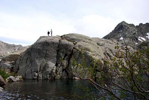 Lac de Capitello
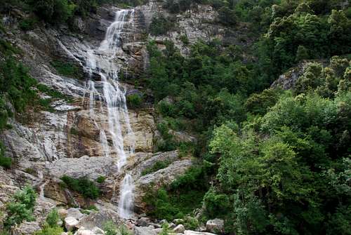
 Waterfall just under the Lac de Capitello
 Landscape with lariccio pine
 Bird's eye view of Corte
 Corte by night
 Corte-the main square
Second day, 11.06.2011, La Restonica
That day the crew decided to take different ways. Half part expected to hike at the outskirts of Monte Rotondo, the other five people wanted to experience the sense of feeling of the granite of Corsica. This disjunction meant that the three hikers had to be transported again up the parking place on the well-known serpentine, after that back to valley in the camping place to pick up the other five guys. The wall is located about 2 km-s from the town (yes, you are right, in direction of La Restonica, road D623 :o). Fortunately, beside the wall there is a parking place, so we did not have to much to walk. The rest of the day we spent on the wall, and at late afternoon the bus was on road D623 again to gather the tired hikers. The rest of evening we spent with the regular activities like dinner, having a bath in the stream, after bathing trying to warm up using some short drinks, falling asleep or having a good time in the downtown. (For that day I did not take any photos, tanks to Tünde and Laci for the climbing and hiking pictures).Második nap: Ezen a napon a társaság úgy döntött, két felé válik. A egyik fél (három tag) a Monte Rotondo környékén tervezett egy egész napos túrát, a fennmaradó öten pedig a La Restonica mászóhelyen (az 1. szektorban) szerette volna megtapasztalni Korzika gránitjának tapintását. Az elválás azt jelentette, hogy a három fő túrázót fel kell ismét vinni a 15 km-es szerpentin tetején levő parkolóba, majd visszatérve a kemping a maradék társaságot begyűjtve a fal alá vonulni. Ez kb 2 km-re van a városközponttól, szintén a D623-as úton, szerencsére mindjárt a fal közelében van egy parkoló, ahol a buszt le lehetett tenni. A nap hátralevő részét tehát a falon töltöttük, volt néhány tartalmas mászás, a kezdeti bátortalankodás és a kőzet jellegének kitapasztalása után. Este még be kellett gyűjteni a túrázós különítményt, ennek érdekében újra, immár harmadszor meg kell tolni a szerpentin a felső parkolóig (harmadszorra már kisujjból megoldottam). Az este további része a szokásos esti foglalatoságokkal telt el: vacsora, üveg fenekére nézés, fürdés a patakban, majd követően lassú kiolvadás némi rövid ital segítségével, majd kinek-kinek alvásra szenderülés illetve dombérolás a cortei éjszakában.
Ezen a napon a fényképezőgépemet szabadságra küldtem, ezért köszönet Tündének és Lacinak a sziklamászós és túrázós képekért.
 La Restonica
 La Restonica
 The Fly ready to climb :o)
 La Restonica
 Come on, Erna!!!
 La Restonica
 La Restonica
 La Restonica
 Around Rotondo
 Around Rotondo
 Around Rotondo
 Around Rotondo
 Around Rotondo
 Around Rotondo
 Around Rotondo
Third day, 12.06.2011.
Saunter in the mountains from Corte to Ajaccio.Harmadik nap: Barangolás a hegyek között (Corte-ból Ajacció felé).

Pozzines in Mount Renoso surroundings. It is one of the weirdest landscapes one expects to find in a Mediterranean island. This group of little lakes and ponds seems to take us to a glacier in the Swiss Alps. This idyllic place can be reached in a couple of hours from Val d'Ese Ski Resort (Val d'Ese Ski Resort. D27A road from Bastellica. It is not a very good road , but wide at least. To reach Bastellica take D27 road from Bocognano or from Cauro (on the N196 road Ajaccio - Bonifacio)).


Fourth day, 13.06.2011., Ajaccio
The evening before just arrived in the town (Ajaccio) we were buzzing around looking for the camping site, my eyes caught in an advertising sign of a diving center. So lucky I was, I decided to dedicate the next day to the sea and the pleasures offered by it. After I had breakfast I walked to a center situated at only one km from the camping. The situation was that I already missed the morning dive, but I could book another one at the early afternoon. Until half past two pm I had some spare time, so I rummaged out my snorkel, the mask and fins, I packed the Lumix in its underwater case and hurried down to the plage just beside the main road. A nice sandy shore with different sized boulders scattered on it and the beautiful turquoise sea. After doing some pictures of the few sea creatures occurring in the water (jellyfish, flatfish, starfish etc.) I had to leave the waves and gather some warmth from the Sun for I started to freeze in an ice cube during half an hour. At the diving center I met friendly people with poorish English but did not mean too much because under the water we could communicate only by signs. The order from the leading diver was ‘I don’t want to see you under me…and of course, when we will ascend to the surface, above me’. Shortly I understood that I had always to keep her depth :o) So detailed we processed down to the water and two boats equipped both with an engine of 150 horse powers. That meant for me that we would reach the diving place quickly…and so was. At the place named Guardiola we jumped very fast in the water from the tumbling boat and soon we were under the water. Only after 45 minutes reached again the surface and another 10 minutes and a crazy boat race the diving center. In my way to our place I was raised from my underwater dreams by the horn of our bus. The rest of my crew was rolling home when someone of them observed me kicking the dust of the road. After we washed down the salt from our tired body we took a round in the downtown, had a fine dinner. Sleeping on seaside on the sand, whizz of the sea and the screech of seagulls as lullaby, salty odour and moonlight…never I should have worse bivvy…Negyedik nap: Tekintettel arra, hogy előző este, miközben a város szélén a kempinget keresgélve kolbászoltunk, megakadt a szemem egy búvár-bázis hirdetésén, úgy döntöttem, hogy ezt a napot a tengernek és általa nyújtott örömöknek szentelem. Reggeli után el is sétáltam a kb egy km-re található bázisra, ahol kiderült, hogy a délelőtti merülésre nem, de a délutánira szívesen látnak. Fél háromig még maradt némi elütni való szabadidőm, ezért előkotortam a snorkel berendezést, a Lumixot belepakoltam a vízálló tokba és lesétáltam a három percre található helyi strandra. Szép homokos part, kisebb-nagyobb szétszórt sziklákkal, gyönyörű türkízkék tengerrel. A tengerfenék is szép homokos volt, a hullámzás által létrehozott szabályos fodrokkal, sajna az élet elég szegényesen képviselte magát, néhány medúzától, lepényhaltól, egy tengeri csillagtól és valami nyálkáshal félétől eltekintve pusztaság volt a víz alatt. Azért amit lehetett, lencsevégre kaptam és húztam is kifele a kb 20-22 fokos vízből. A nap éppen felhők mögött álldogált a zeniten, viszont a víz felől vékony, hűvös szél fújdogált, így következő negyedórát vacogással töltöttem, gyakran az ég felé sandítva, hogy elpucolnak-e már a felhők mielőtt kockára fagyok. Aztán, amire indulnom kellett a bázisra, a nap végre kisütött, szép kirándulás ígérkezett. A bázison kedves emberek fogadtak, szegényes angol tudással, ami szerencsére nem sokat számított, tekintve, hogy a víz alatt úgyis csak jelekkel tudtunk értekezni egymással. Az instrukció csak annyi volt a merülésvezető lány részéről, hogy nem szeretne merüléskor maga alatt látni, ugyanez érvényes az emelkedéskor is, csak ebben az esetben a felette lévő a tiltott zóna. Reméltem, ennek maradéktalanul eleget tudok tenni, le is vonultunk a csónakokhoz, melyeken egy-egy 150 lovas bazi nagy motor éktelenkedett, azt vetítve előre, hogy gyorsan a helyszínre fogunk érkezni. Ez meg is történt, és gyorsan kikötöttünk a Guardiola nevű helyen, ami szerintem hajdan egy világítótorony volt. A hánykolódó csónakból igyekeztünk mielőbb a vízbe kerülni, aztán pedig a víz alá, ahonnan csak kb ¾ óra múlva kerültünk elő. Hazafelé volt még egy kis csónakverseny, ami az agyunkat kissé összezilálta, de végül rendben visszaérkeztünk a bázisra. Hazafele sétálás közben dudaszó ugrasztott ki ábrándozásomból, kiderült hogy a többiek is éppen hazafele tartottak a busszal, így megspóroltak nekem pár száz méter kutyagolást az útmenti porban. Este még egy kis séta és egy jó vacsora várt ránk a városban, ezután pedig, ha már a napot a víznek szenteltem, alvás a tengerparton a fövenyen, az altatót a tenger morajlása és a sirályok vijjogása szolgáltatta. Soha ne legyen rosszabb szállásom…


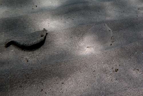

 Kind of blenny

Guardiola-Ajjacio from István Nagy on Vimeo.
Untitled from István Nagy on Vimeo.
Guardiola-Ajjacio from István Nagy on Vimeo.

 Sea urchin
 Mediterranean rainbow wrasse
Boat race from István Nagy on Vimeo.
Fifth day, 14.06.2011, Les Calanches
Up the western coast, driving or cycling along coastal D81, you curve around a headland to the tranquil village of Piana, with its red-tiled roofs rising 440m (1,444 ft.) above the azure sea. But beyond Piana, you enter an altered reality: The granite landscape to either side of the twisting road begins to turn red and become strangely striated and crumpled. The highway seems hacked out of the mountainside, and it zigs and zags crazily to cling to the corrugated rock faces. And so it goes, all the way along the southern end of the Gulf of Porto, from Piana over to Porto.Les Calanches remind me of the buttes of Monument Valley, but smaller and more eccentric, crabbed like the figures of arthritic old crones. And then, of course, there's that dynamite seaside backdrop setting it off, the hazy blue of the Mediterranean contrasting dramatically with the sharp-focused red rocks. As you drive along, ask the children to try to decide what these oddly shaped boulders remind them of—a rearing stallion? A fire-breathing dragon? A stegosaurus? Patches of green pine scrub, snarls of gray thorn, and bursts of dark red and yellow flowering shrubs decorate the creased red-granite spires here and there, and the shoulder of the road drops with heart-stopping suddenness to the waters below. The road bends so sharply, you can't see beyond the next curve—honk to warn oncoming drivers of your presence before you pull around to the next dizzying view.
Ötödik nap: Ajaccio felől a D81-es úton haladva, egy hegyfokot megkerülve érkezünk el Piana városkába, mely vörös cserepes házaival 440 méterre emelkedik az azúrkék tenger fölé. Pianat elhagyva, a vándor(ok) egy másik valóságba léphet be: az kanyargós utat mindkét oldalról szegélyező gránit-falak vörössé és erősen barázdálttá, gyűröttekké válnak. Az út, mint egy a sziklába vésett forradás, őrült módon cikk-cakkban futva kapaszkodik a hullámokat vető kőtengerbe. És ez folytatódik végig a portói öböl déli végéig, Pianától Portoig. A táj mogorva, mint egy izületi gyulladásos vénasszony, tele göcsörttel, mintha görcs rántotta volna csomókba a hegy rücskös bőrét. Háttérként a tenger, ködös kékje drámai kontrasztot fest az vörös sziklák csipkéje mögé. Ha gyerekkel utazol, kérdezheted tőle, hogy különös formájú sziklák mire emlékeztetik: egy ágaskodó ménre, egy tüzet okádó sárkányra, esetleg egy dinoszauruszra? Fenyőfák zöld foltjai, egymásba gabalyodott tövises bokrok tarkítják a robbanás színeit idéző gránittornyokat, az útpadka pedig lélegzet-elállító hirtelenséggel szakad le a víz felé, a szédítő mélységbe. Az út olyan élesen kanyarog, hogy a hajtűkanyarokat képtelenség belátni, az autósok tülkölve figyelmeztetik az esetleges szembejövőt, így is gyakran előfordul, hogy két autó csak tükröt behajtva, fél kerékkel a meredély szélén lógva vagy a falhoz tapadva fér el egymás mellett.


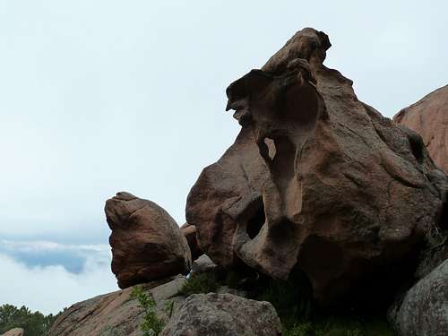
 Christmas-tree a'la Les Calanches


 Gulf or Porto from Capu d'Ortu
 The team at Capu d'Ortu. From left: Karesz, Gee, Erna, Ági, Laci, myself

 Yellow-billed Chough

Western coast
Moments on the western coast, from Ajaccio to San Florent.Pillanatképek a nyugati partról, Ajaccio-tól San Florent-ig.


 Citadell of Calvi
 Port of San Florent
 San Florent by night


 Anemonia viridis
 Anemonia viridis
 Jellyfish

 Gastronomic delight in San Florent
Last day
From San Florent to Bastia.Utolsó nap: San Florent-ből Bastia-ba.
Corsu e sempre Corsu! Au revoir, belle Dame!
 Church of San Cervone
 Village of Patrimonio
 Bastia again-the main square

 The old harbor of Bastia
 Bastia, the old town
 Last steps to the port
The old port of Bastia from István Nagy on Vimeo.


Comments
Post a Comment