
|
|
Route |
|---|---|
|
|
37.87820°N / 119.0072°W |
|
|
walk up |
|
|
Half a day |
|
|
Class 2 |
|
|
Approach
Round-trip distance to summit: 5 miles (approximation)
Total elevation gain: 1,700 ft.
A moderate pace should probably get you to the summit within 2 hours from your car.
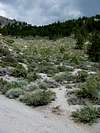
Proceed to the base of the mountain as described in the “Getting There” section. Park your vehicle. At 6.2 miles from the 395/120 East junction, the dirt road will veer sharply left- basically at this turn, you will see (if you squint) footprints between the desert brush. This is the beginning of the trail (Check out this photo).
 |  |
Route Description
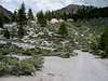
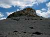
Follow this trail as is switchbacks up the mountainside through the forest. It will eventually end up at the saddle between Crater Mountain & the butte to its north, almost directly above the beginning of the trail just described, if looking directly ahead. Follow a use trail (if present) from the saddle up the steep pumice scree between the volcanic outcroppings to the summit plateau/crater. The true summit, a volcanic plug, will be obvious. Take a semi-trail up this on its north side (class 2), or go to the W side & scramble up its face (mostly solid, enjoyable class 3).
Go back the way you came.
 |  |
Essential Gear
Bring plenty of water, esp. during the summer. To my knowledge there are no reliable water sources near or on the mountain. Scree gators are also a good idea. Binoculars & camera a must.
Miscellaneous Info
If you have information about this route that doesn't pertain to any of the other sections, please add it here.