The Drive In
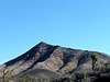
![Clark Mountain]() Clark Mountain from I-15.
Clark Mountain from I-15.I drove to Crescent Peak on the morning of Thursday, January 18, 2007. I stayed the previous evening at Whiskey Pete’s Casino at State Line (Primm, NV). That morning when I walked outside it was sunny, chilly, and windy.
I started driving south on I-15 into California. There were great views in all directions. Clark Mountain dominated the sky line to the SW of the Interstate. I drove south up to the pass I turned East onto Nipton Road (Joshua Tree Highway). It was very wide open desert with views of Castle Peak and Cathedral Peaks in the distance. My ears were popping from the climb in elevation as were my friend’s. Eventually we drove through the small town of Nipton, CA on the border.
Crescent Peak came into view just before crossing the border. I stopped at the state line and took some pictures of Crescent Peak. I then headed a few miles East and turned south onto Crescent Peak road. Having never been down here I was scared and turned away by signs along this road. There were private property signs not far up the road so I turned around and tried to find another way. I later found out from
MoapaPK’s research on the Clark County Assessor website a layout of the BLM land in the area. I looked at the map and realized that these private properties were just off the road but I could have continued south on Crescent Peak Road.
I went back to the Highway and turned east and looked at ways south of the Highway to turn south toward Crescent.
Stormchaserd got out and went up some dirt roads to check them out. Eventually we came across North Crescent Peak Road a mile or so past Crescent Peak Road turnoff. We headed south on Crescent Peak Road.
After driving a little ways up North Crescent Peak Road we came to a three-way fork in the road. There was a “no trespassing” sign but it was aimed for the middle and left forks. We took the right fork and drove down a little ways. We saw a turnoff to the left off this road and
stormchaserd, my hiking partner, started walking up this road to check it out. In the distance he noticed a trailer and some vehicles. We then decided not to take this turn. The main road off the right fork continued on over a hill though.
Stormchaserd continued hiking over this hill and down to check things out. After about 15 minutes I hadn’t seen him and started yelling for him. Finally my cell phone rang and it was him. He told me to start driving down this road. I continued on over a hill and after a little ways I had to start using 4WD. There were lots of brush and trees along the side of the road scrapping the side of my pickup. They were only minor scratches though that can be buffed out. Eventually I saw
stormchaserd and parked. At this point
Stormchaserd had already hiked about a mile or so before we started our main hike.
Later after the hike when I looked at the BLM map of the area, I saw that I was on BLM land the whole time I drove in.
The Hike
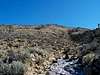
We started hiking down a wash heading SW away from the peak. Our starting elevation was about 4,576 feet. After about 0.2 miles from where we parked there we went around a curve that headed towards the peak and there were rocks on the left side of the wash. I posted a route description for this route. We followed that route to the summit.
Along the way as we got into the wash before the saddle there was ice in the wash. We saw some dried snake skin along here. We didn’t see any live rattlesnakes though. I’m sure they are out here though. We then hiked for the saddle along Crescent Peak’s west ridge.
Once on the ridge we hiked and scrambled to the summit. It was about 0.6 miles up to the summit. It was mostly class 2 all the way up the ridge. From the summit there were great views of McCullough Mountain, Kingston Peak, Clark Mountain, Spirit Mountain, and much more. It was windy and chilly on the summit. The total distance to the summit was 2.0 miles.
After resting on the summit and taking many photos we started hiking down the west ridge. We went a little past the saddle then started hiking down into the wash we came up. After about 1.1 miles down from the summit we got onto a road past the wash. We followed this road another 0.4 miles and then turned onto another rough road for the last half mile to my pickup. We looked back often at the summit and enjoyed the views of the Joshua Trees. Be careful of brush and stickers and thorns on plants out here and watch your step.
The Drive Out
It was now time to leave. Driving the first 0.5 miles east back up the road we came up was rough 4WD again. Once we got to the bottom of the hill we came over though it got better. After coming over the hill we came back to the 3 way fork we turned at and started heading towards Nipton Road. I took lots of photos. I saw a big pile of boulders along the side of the road with Crescent in the background and took advantage of this photo opportunity.
Once back on the road it was already 3:00 PM. I wanted to hike McCullough Mountain today as well but with less than 2 hours of daylight left that was not in the options. We started driving for Laughlin. The next day we attempted Spirit Mountain’s tough south ridge, which is not the normal route up that mountain.
Comments
No comments posted yet.