

-
 16238 Hits
-
 75.81% Score
-
 6 Votes
|
|
Route |
|---|---|
|
|
45.94250°N / 7.86900°E |
|
|
Mixed |
|
|
Summer |
|
|
SS / V |
|
|
Approach
This page will be kept in honour of Stefan Weber, the SP member known as kletterwebbi, the former owner of this page, died on May 28th 2004 in Southern France at the age of 37.
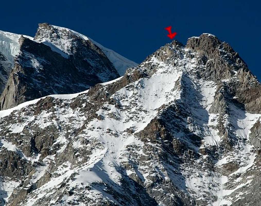
Cresta di Santa Caterina
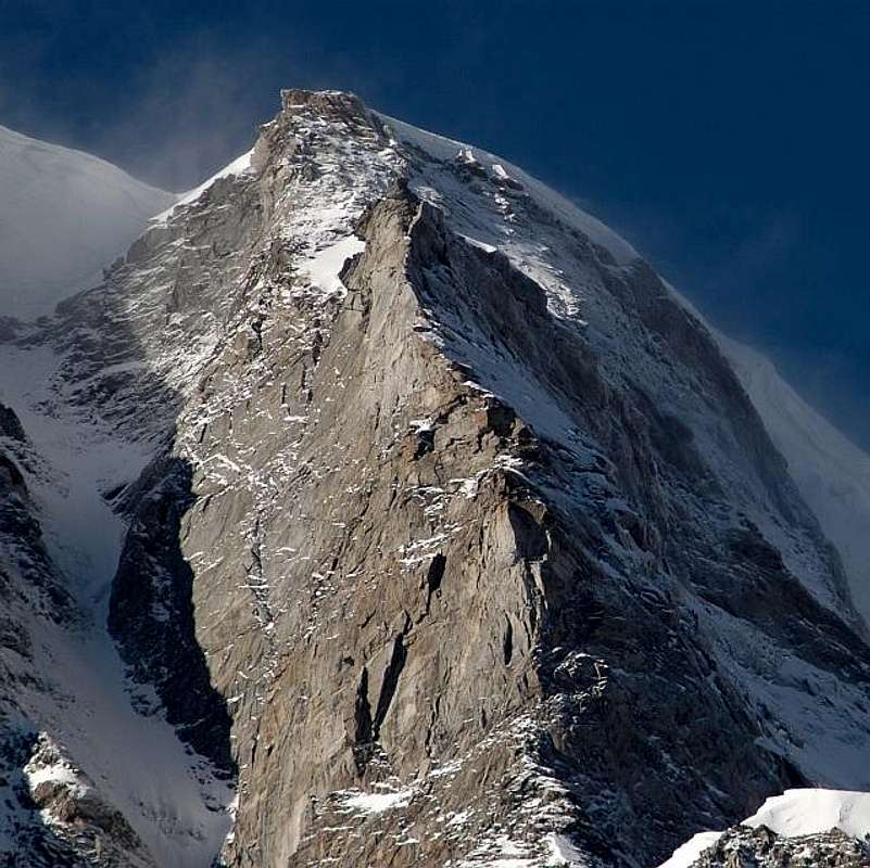
This classic and demanding route faces NE and runs along the border crest which from the 4352 altitude of Punta Nordend, located North of the summit, descends towards the NE down to the large snowy saddle of Jägerjoch 3910 m presenting four rock protrusions. It is a very airy and exposed route, with different possibilities of variations, rather safe from the point of view of objective dangers and on fairly solid rock. In fact if compared to all the other routes on the Himalayan East Face, the Santa Caterina ridge is practically devoid of objective dangers, moreover it develops on good rock for about 400 meters of rock climbing, interspersed with some snowy and mixed sections. It is a great classic race on the highest face of the Alps.The setting is spectacular.
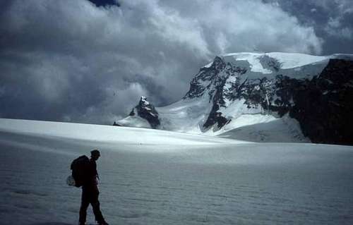
The best and easiest solution is starting from Zermatt. Pay attention: the Stockhorn cable car has been closed, so you have to start from Gornergrat. Climb the ridge and then the glacier up to the Jagerhorn (at least 6 hours).
- It's also possible to start at the Monte Rosa hut (crevasses), then you will reach the Jägerjoch without touching the Stockhorn then. It will take about 5/6 hours from Zermatt to the Stockhorn.
Route Description
Cresta di Santa Caterina
Difficulty: TD (Alpine scale), V+ UIAA on the first rocky prominence
Difference in level: 700 m, 450 m the ridge
Exposition: NE
Classic route, great high mountain mixed climb. It requires excellent training, a good rock climbing technique, a good command of the use of crampons and ice axe.
First Day
Uphill difference in height 890 meters - 5/6 hours

Start at the Gornergrat station 3089 m. From there you must reach the Città-di-Gallarate-Biwak (CAI, 3970 m) near the top of the Jägerhorn, NE of the Nordend. From the Stockhorn station hike up to the Stockhorn saddle between Grenzgrat and Stockhorn and follow the flat, mosty harmless Gornergletscher direction Nordend.
There is a wide snow saddle between Jägerhorn and Nordend (Jägerjoch, good visible from the Stockhorn station). This saddle must be reached. The ice flank below the saddle is somewhat steep with few sometimes tricky but most times big but harmless crevasses. On regular conditions there will no path at the glacier, so it's better to start early while the snow isn't to soft. It will take about 4 -5 hours from Stockhorn station to the bivy.
You should remember the altitude: the Città-di-Gallarate-Biwak is situated at 3970m ! Spending the night at this altitude may cause problems if one is not acclimatised.
Second Day
Uphill difference in height 450 meters - 5/6 hours
From the bivy the route is clearly visible. Start at the bivy, go down to the Jägerjoch and reach the start of the NE-ridge called "Cresta Santa Catherina" (about 4000 m) on easy, broken rocks and snow.
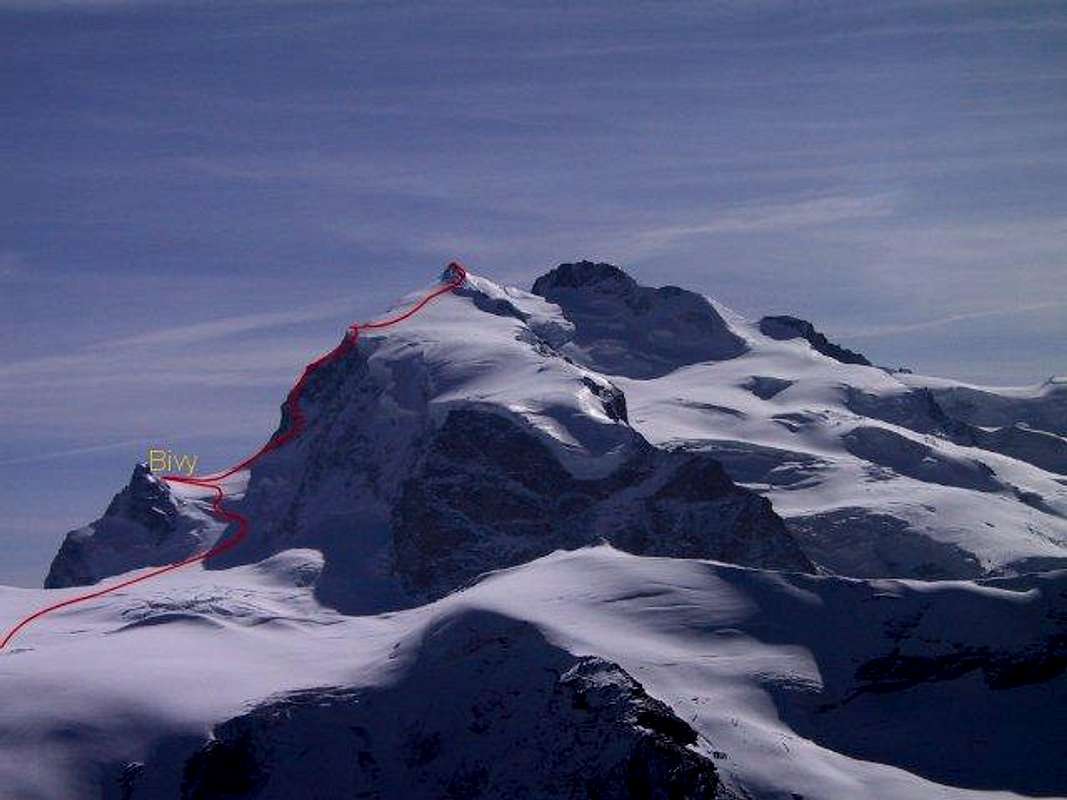
The Cresta di Santa Catherina follows the ridge between Punta Nordend East wall and Nordend North flank. Most time the route uses the right flank of the ridge, it's more a face climb then a ridge. There are three main steep steps, all of them will be climbed at the right side of the ridge.
A short approach leads at the foot of the ridge Ora incomincia la lunghissima discesa attraverso la via normale dalla Monterosahutte fino alla stazione intermedia di Rotenboden mt 2815. Rientro a Zermatt con il trenino del Gornegrat.
Difference in level:
The first step is the highest and most difficult part: first climb up a kind of a chimney (some pitons) rightwards. This brings you to some slabs. Climb the slabs at the right hand using a small dihedral (pitons). Some pitches on rock and ice/snow brings you at the top of the first step (UIAA grade 4 and 5, ongoing, very strenuous).
The next pitches are not as difficult as the first part, they are on mixed terrain. After about three pitches you will reach the base of a big area of slabs covered with snow and ice. This is the crux of the route : there are only bad possibilities to place gear, on bad conditions this part will be dangerous and very difficult. At the guidebook, those slabs are described as to be climbed directly in two pitches of UIAA 4.
There is an other option: try to climb as near as possible to the real ridge (we used the ridge itself). We have found it much better to climb at the ridge instead of the slabs of the face. But this may depend on the actual conditions.
Near the top of this slabs on have to climb directly the ridge. This are two superb, very exposed pitches, real good climbing there (UIAA grade 4 but demanding). Take a deeeep lock down the Nordend E-face there.
Now you'll reach the snow crest below the final third step of the ridge (easy). Go up using the snow crest brings you to the base of the third step. Some more easy pitches on broken rock will lead you to the top of the ridge at about 4450 m.
The summit is visible at the left. No more difficulties up now. You reach the summit using the big snow and ice fields.
Over all it's a steep, serious ice and rock climb. The route is more like a face then like a ridge climb. Some dangerous parts. No icefall, less rockfall. You'll need about 7 - 9 hours from the bivy to the summit.
Descent: very long, following the standard route via Silbersattel to the Monte Rosa Hütte (downhill about 2000 m).
If you're fast and strong you may continue this epic from the Nordend to the Dufourspitze and the other 4000 meter peaks at the Monte Rosa area.
Essential Gear
High mointain clothes, stoppers, 2-3 Friends, crampons, ice axe (one), double rope. Bring some pitons, in case of trouble this may be helpfull.
Huts and bivouacs
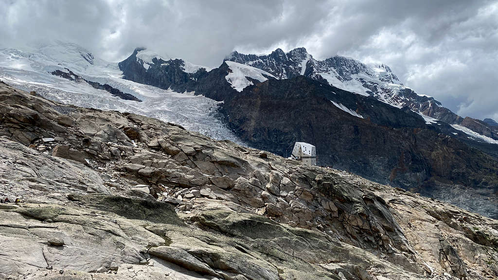
Monte Rosa Hut
Starting point: Rotemboden
Starting altitude: 850 m | Difference in height: 940 m | Journey time: 3/4 hours
Opening Period: from mid-June to mid-September
Beds: 120 places (For hygiene reasons, a sleeping bag is mandatory)
Management: Swiss Alpine Club (Manuela and Horst Brantschen)
Tel. +41 027 967 21 15 | +41 027 956 31 50
Bivacco Città di Gallarate CAI Sez. Gallarate
Classic half-barrel bivouac, with 9 beds and blankets. It is located 10 m below the summit of the Jagerhorn 3970 m on the rocky ridge emerging from the Gornerglecter, just below the North ridge of the Cima Nordend. Refurbished in 2012.
Access: the bivouac can be reached both from the Italian side (Macugnaga) and from the Swiss side (Zermatt). Both accesses are high mountain mountaineering routes. The simplest is access from the Swiss side.
When to climb
July - September
Meteo
MeteoSwitzerland
Meteo Valle d'Aosta
Guidebooks and maps
Guidebooks


 Guidebook")
"Il grande libro dei 4000" by Marco Romelli, Valentino Cividini - Idea Montagna Editore, 2015
-“Monte Rosa” by Gino Buscaini (Club Alpino Accademico Italiano) – Collana Guide dei Monti d'Italia CAI-TCI (Club Alpino Italiano-Touring Club Italiano)
"Walliser Alpen" Vol. III, Swiss Alpine Club (German and French)
-“Tutti i 4000” – L’aria sottile dell’alta quota” – CLUB 4000 CAI TORINO – Vivalda Editori
-“The 4000 of the Alps” by Richard Goedeke (CAAI) – All the normal routes to the 4000m. summits of the Alps – Libris Edition
-“Le Alpi Pennine, le 100 più belle ascensioni fra il Gran San Bernardo e il Sempione” by Michel Vaucher - Zanichelli Editore“
-“I Quattromila delle Alpi” by Karl Blodig and Helmut Dumler – Zanichelli Editore
-“100 scalate su ghiaccio e misto” by Walter Pause – Gorlich Editore
Maps

"Breuil/Cervinia-Zermatt" Kompass map 1:50.000
"Cervino-Matterhorn e Monte Rosa" n. 5 - Istituto Geografico Centrale map 1:50.000
"Matterhorn - Mischabel" n. 5006 map 1:50'000
"Zermatt" n. 1348 map 1:25'000