
|
|
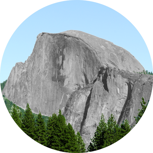
Mountain/Rock |
|---|---|
|
|
37.23837°N / 105.15456°W |
|
|
Las Animas/Costilla |
|
|
Hiking, Mountaineering, Scrambling, Skiing |
|
|
Spring, Summer, Fall, Winter |
|
|
13487 ft / 4111 m |
|
|
Overview

Cuatro Peak shares in the same problem that most of the other area peaks suffer from...access. Granted, there is a legal and viable way to access Cuatro's summit but as far as I know, reasonable access is limited. See the Routes and Red Tape sections below for further information.
Cuatro Peak lies on the boundary of San Isabel National Forest to the east and private land to the west. Cuatro Peak is a moderately-elevated peak in the Culebra sub-range of the Sangre de Cristo Mountains.
The Culebra Range itself occupies a small area within Colorado (about 60% of its land area) and even smaller in New Mexico (about 40%). The total area only encompasses about 3,740 sq./miles (9,689 sq./km). It extends 93 miles from north (La Veta Pass) to south (Big Costilla Creek) in New Mexico and roughly 75 miles from east to west.
This range encompasses mountains such as: Vermeijo Peak, Napolean Peak, Cuatro Peak, State Line Peak and towns like Segundo, Trinidad, La Veta and the Spanish Peaks State Wildlife Area. The highest point is the range's namesake, Culebra Peak (14,047ft).
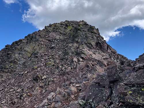
Cuatro Peak received its' name because in some years, in early summer, the couloirs on the eatern side will form a roman numeral IV. It all depends on the snowpack. Simple naming but at least its' title is still in spanish in accordance with the area.
Cuatro Peak lies within the Trinchera Peak Quadrangle and is shared by both Costilla and Las Animas Counties. It maintains a respectable 707ft of prominance and drops to a low saddle of 12,780ft with its proximate parent, Trinchera Peak.
Although Cuatro Peak has no official trail to its summit, the mountain is classified as a class-2 hike by virtue of its easiest route. Among Colorado's parthenon of mountains and peaks, it is the 264th highest. It lies 2.23 miles south of its loftier neighbor, Trinchera Peak (SP) and roughly 0.63 miles north of Mt. Maxwell.
Surrounding vegetation is noticeably complex and in line with that of a drier climate. Most often, Piñon-Juniper woodlands and Ponderosa Pine exist on the lower slopes and it is common to see large swaths of Aspen, Engleman-Spruce and even Douglas Fir higher up. Limber Pine and Bristlecone Pine have even been noted in isolated pockets on the higher slopes.
If one is lucky enough, lynx can be seen as well as bobcat. Bear do live in the area and the main staples, white tail deer, elk and bighorn sheep also reside in these mountains.
When venturing to Cuatro Peak, expect the private lands to inaccessable (but roaded) and most of the accessable lands (National Forest) to be roadless. This is a fairly isolated and consequently, pristine area. Infrastructure is limited at best and no industry exists in the area to support a population. These lands are meant for fisherman, hunters and hikers (where possible). Solitude and unspoiled views are this areas gem features.
Getting There
Because of the private property located to the west, approaching from the east is the only viable option. If one is coming from the north (Walsenburg), travel west on Hwy. 160 for 12 miles to the turnoff for Cty. Rd. 12. Head south for 4.7 miles coming to the town of La Veta (mineral vein in spanish). Continue south for another 26.3 miles passing Cuchara Pass and North Lake.
The turn off for FR. 34 is JUST after North Lake. This turn is marked with a brown forest service sign indicating Purgatorie Campground and a [private] seasonal residence lies on the other side of the road. Turn right at this T-junction and head west for 0.2 mile to another T-intersection (dirt roads).
Turn right and follow the road for 4.3 miles up the North Fork of the Purgatorie River. The road will dead-end at the campground. Park at the campground and walk back down the road for 0.2 miles to the turnoff for FR. 437. This Jeep Road will climb and switchback frequently up Maxwell's Eastern flanks for another 3.2 miles to a rather nice 4x4 parking area.
There is also the option of parking directly at this junction (lower down) of #437 and #34 as there are two small pullouts that will accomodate passenger cars.
Red Tape
Cuatro Peak lies on the county line of Las Animas and Costilla. But this is where things can get messy. The red tape surrounding this peak can be a bit of a problem as there are different jurisdictions that involve: BLM, private and SWA.
There is private land surrounding the Spanish Peaks and technically, West Spanish Peak is entirely private. However, due to an agreed upon easement with the Forest Service, access is granted to this volcanic peak.
Large swaths of the southeastern side of Cuatro Peak are private. The Northern aspects of the Culebra Range are National Forest (San Isabel & Pike) so public access is allowed. The western aspects are all entirely private due to the historical Sangre de Cristo Land Grant (1843) and the private Culebra Ranch. There is also some BLM land in the area but this is regulated to the northern aspects of the range.
A small section of 'Wilderness Designation' exists just north of the Spanish Peaks closer to Hwy. 160.
From the summit of Mt. Maxwell clear to the New Mexico State Line (read: Mariquita, De Anza Peak, Francisco, "Whisky Pass Peak" etc.) is also all private. This...I have on good faith directly from the sheriff in Trinidad.
Year round access is via the previously mentioned FR. 34. I only make mention of the entire area to give an idea of the complexities involving public and private lands and that these things are rarely a cut & dry process. For further information, give the Colorado Parks and Wildlife Office a call.
Monte Vista Office
722 S County Road 1 E
Monte Vista, Colorado 81144
719-587-6900
Camping
The most convenient area for camping is of course, Purgatorie Campground!
This campground lies at the end of FR. 34 at 4.2 miles. It is 0.2 miles past the turnoff for FR. 436 (Maxwell Peak).
The campground is open from May to September at an altitude of 9,800ft. Snow conditions can of course dictate late openings.
There are vault toilets, water is available and the fee to stay here is $13.00/night for a maximum of 14 days. There are a limited number of RV sites.
For reservations, call: 1.877.444.6777.
The campground was originally constructed in 1976 by the Youth Conservation Corps and initially called the Potato Patch Campground.
There are two main loops.
One encompasses mostly open grassland which will accomodate RV's and trailers and the smaller loop lies within the forest proper. These sites are meant for tent camping.
Another alternative is to drive the Jeep Road (#436) up Mt. Maxwell's Eastern Slopes to the upper 4x4 parking area. This flat and protected area is above 11,000ft and located on the right. There is enough room to accomodate 5-6 vehicles and there are plenty of flat areas amongst the trees. Doing this would make Cuatro Peak as easy as they come.
Routes
There are two reasonable routes to reach Cuatro Peak's summit. Both are detailed here. There is a third possibility that approaches it from the north via Trinchera Peak but due to the sheer length, I won't detail it here. Although in hindsight, it would make for a decent and very long loop.
1.) Mt. Maxwell (East Ridge)
For passanger vehicles, park in one of the two small pull-outs located at the bottom of FR. 436 or up the road at the Purgatorie Campground. This will be your starting point (9,700ft). For those with 4x4 capabilities, continue for ~3.2 miles up FR. 436 to the parking area. The road switchbacks frequently. This will be your starting point.
Leave the Jeep Road and follow the mellow ridge through the forest to treeline. The ridge will NOT be apparent while in the forest. Keep a steady trajection west until treeline is breached. Just past treeline is an obvious headwall. Hike up this slope (treacherous in winter) to the tundra. The slope will dramatically flatten out and the blocky East Ridge will be in view.
From the flats above the headwall, the summit of Maxwell is only 0.6 miles away. The blocky and sometimes cracked/fractured east ridge is a delight to scramble on. It's predominantly class-2 with an occasional 3rd class move. The easy scrambling along this ridge to the summit is bliss!
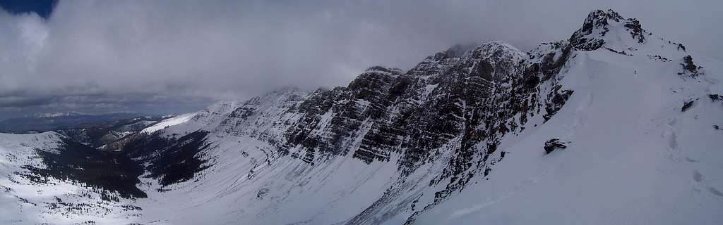
Descend north and re-climb along the connecting ridge for 0.7 mile to Cuatro Peak. The ridge turns to easy 3rd class after the saddle. Cuatro's summit is fairly large, flat and featureless. The scrambling is secure and exposure is moderate.
2.) Toby Canyon
This approach starts directly at Purgatorie Campground. It initially takes a northwest approach on a faint trail. Keep in mind, further into this approach, the trail will disappear in places and (or) become primitive as it heads into Hell's Canyon (between Cuatro & Maxwell). But no official path exists.
Leave the campground on a fairly good trail heading northwest following the Purgatorie River. The first break in the slope to the west will be Hell's Canyon. This drainage works for an ascent path or even descent if one's route finding skills are competent. Continuing north, the next drainage encountered to the west is Toby Canyon. Leave the maintained trail and bushwahck directly up the mellow slope (willows & talus). A faint climbers path will weave in and out of focus until the upper tundra can be reached. From this point, the trail will be become a bit easier to follow as it winds up the very gentle eastern slopes in between Cuatro Peak and "South Leaning Peak". Take the ridge south to Cuatro. This approach does not exceed easy class-2.
Return the same path or descend into Hell's Canyon (bushwhack) for a loop or hike further south along the ridge to the summit of Maxwell and follow the Jeep Road back down to the road.
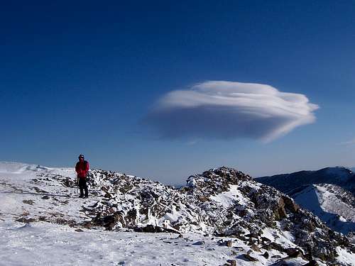
Winter Access/Beta
 |
||
This area is possible to explore in winter. However, FR. 34 is NOT plowed or maintained in the winter. The closure, although it is not gated, may very well be the intersection with Hwy. 12.
The lower stretches of this road do not melt out as one would expect. Middle sections however, do regularily. This is aggravating especially if one has to park three miles down the road and dry sections are then encountered further up. This is just a common trap of doing 'business' in the winter. The lower road is fairly avalanche safe.
I wouldn't recommend ascending Toby Canyon or Hell's Canyon if the snowpack is unstable or heavy. The upper slopes in these drainages are ripe for slides and loading.
The Jeep Road would be the safest alternative to this. Plus, following the road takes the ever present challenge out of route-finding. The only concern to this approach in winter is the headwall at treeline. Fortunately, this is the only concern. Unfortunately, this is a big concern as the slope is in the low 30's (pitch) and actually increases to climber's right (north). Once past this, the summit is virtually guaranteed.
The Jeep Road is also avalanche safe. If no packed trench exists, this will be a brutally long day.
Weather

External Links
Sangres.com (miscellaeous beta)
(SSF: Southern Sangre Fun) -Trip Report from 14ers.com
Home Town Locator (Area Hotels)


Topo Map
![]()