Approach
To reach the Lofty Lake/Pass Lake Trailhead, drive Highway 150 32 miles north, and east of Kamas or 46 miles south of Evanston. There is a sign that marks the trailhead (west side of the Highway).
![]()
Route Description
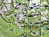
From the trailhead (at 10,100 feet elevation), find the trail heading west. There is a sign pointing the way to Lofty Lake. After heading west a short distance, there is a junction. The trail to the left (east) heads back to Highway 150 just accross from Pass Lake, so turn right. Continue west from the junction and reach another junction after just a short distance. There is a sign at the junction. Turn right and take the Lofty Lake Trail. After another .5 miles, Reids Meadow (just below 10,000 feet elevation) is reached. There is a spectacular view of Reids Peak and Bald Mountain from this meadow. From Reids Meadow, the trail climbs uphill to the north. Here's where you will need a map and you will
have to pay close attention to landmarks and to your where-abouts. Just after two ponds are reached, look very carefully for a lesser-used trail heading to the west. It is hard to find and the junction is not signed. You may miss it. This lesser used path of sorts, more like a cross-country route, heads to Cuberant Lake after 1.5 miles. Keep a close eye on the map! The trail/route heads northwest around Mount Marsell from the Lofty Lake Trail. The hard to find trail then climbs over a minor ridge and heads north to an un-named lake just before reaching Cuberant Lake (10,350 feet). Cuberant Lake is in a very beautiful area and there are six other un-named lakes in the area. From the lake, you can either climb the slopes straight southeast and to the summit, or head west and slightly south up a gully to the ridge-top From the ridge-top, the follow the ridge south to the summit of Mount Marsell. Round trip distance is about seven miles.
Essential Gear
A good pair of boots is needed.
Miscellaneous Info
If you have information about this route that doesn't pertain to any of the other sections, please add it here.