The Question
“Why don’t Americans come to Bolivia?” asked our tour guide.
“I have no idea, I really don’t.” I responded as I thought about the numerous Europeans, and the ubiquitous Australians, I had already met; but very few Americans.
After three weeks in the Bolivia I still don’t have an answer to our guide’s question. From our experiences there is no reason not to visit Bolivia and many reasons you should plan a visit. While we did meet other travelers from the USA during our time in Bolivia we were a minority among our fellow travelers.Exploration & Acclimatization
La Paz
Our team included me, Axe and our father, the Old Guide, on this trip. We planned several days of acclimatization around La Paz experiencing the culture and the county before heading to the Condoriri section of the
Cordillera Real to attempt
Pequeno Alpamayo followed by
Huyana Potosi. After a needed rest, and seeing Old Guide off on his return home, Axe and I would finish up our holiday with a six day trek to climb
Illampu.
![Palacio Presidencial]() Plaza Murillo
Plaza Murillo
Our arrival day was low key which was especially good since we were at 12,000ft/3657m. Our hotel for the entire time while in La Paz was the Hotel Rosario, a three star hotel with excellent service, nice comfortable rooms and a very good restaurant. Its located in the Aymara district on Illampu Street which offers plenty of choices for eating, shopping—the famous ‘witches’ market and getting to know the city. They sent a driver to pick us up at the airport.
We met with Miriam from our outfitter, Bolivian Mountains, to review our schedule and to discuss the services we hired. Bolivian Mountains is a full service climbing company and can provide guides, cooks, mules and many tours. We hired them for transport to the mountains and to provide cook support on our Illampu climb. We had no issues at all with their services. I highly recommend them and will use them the next time I climb in Bolivia.
Tiwanaku
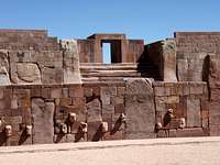
The next day started with an early departure for a day trip to Tiwanaku, the pre-Incan ruined city three hours away near Lake Titicaca. This site dates to 1000 BC based on potato growing and llama herding. By 100 BC it had developed into a city state with a class structure of priests, warriors, artisans and royalty. A few hundred years later it was the center of an empire that controlled the entire Titicaca basin. It continued to expand and dominate the area of modern Bolivia, southern Peru and the northern area of Argentina and Chile. Intensive agriculture and control of the trade routes drove the expansion until after 1000 AD the city rapidly declined and was abandoned within 50 years. The primary cause appears to be climatic change in the form of a long term drought.
![Twanaku Map]() In 3D
In 3D
Our guide for the day was Luisa. She is a professional tour guide and is very knowledgeable about the ruin. When we first arrived at Tiwanaku we went through both museums. The new museum is currently under construction and is only partially open. The older museum is noticeably dated; its exhibits will be moved once construction is complete. Currently all exhibit signs are in Spanish so Luisa was very helpful in interpreting the exhibits.
![Temple and Plaza]() Temples and Plazas
Temples and Plazas
After touring the complex we went into town to see the town square where their Catholic church has two Stella (statues) from the ruins on each side of the entry gate. In many places in the New World the Spanish built their churches on top of the temples and religious sites of the local cultures. This is the first time I’ve seen it where ancient stone artwork was incorporated into a church’s design and not just used as a block in the wall.
Lake Titicaca & the Isle del Sol
The following day found us once again leaving La Paz early for a two day tour of Lake Titicaca and the Isla del Sol with an overnight stay in Copacabana. Our guide for this trip was Elsa. We arrived in Copacabana in time for lunch. Considering the proximity to the lake the local specialty is fish. Three main types are trout, perjerry and ipsi with the first two being main dishes and the latter more of a sardine/minnow sized appetizer. We ate all three varieties several times—delicious!
After lunch we went to the Isla del Sol for the afternoon. The lake region has been an important focus of religions for centuries. The Incas believed that their creator god, Viracocha, rose from its waters. They also believed that their own ancestors came into being here. The Isla del Sol and Isla de la Luna have numerous shrines and temples dating back to Tiwanaku’s reign.
![Escalinata - Isla del Sol]() Escalinata on Isla del Sol
Escalinata on Isla del Sol
The ferry boat was well worn with small, hard and narrow seats that were bolted to the deck. Rooftop seating was an option for anyone well covered in sunblock. Once we were out of the harbor the boat experienced ‘mechanical difficulties’ in starting up the second outboard motor. Without its twin the working motor pushed us along at such an easy pace that a grandmother could beat walking. So we settled in for a long, but scenic, ride on Lake Titicaca. Axe took advantage of the time to have a private Spanish lesson with Elsa while she worked on her English skills.
Arriving on the island hours late we could only hike from Escalinata to Pilkokaina in about an hour. We explored one Incan era ruin toward the end of our walk. The ‘mechanical issue’ still existed so our trip back to Copacabana took even longer with a headwind getting us into town right at sunset.
After breakfast we went out to explore the town for several hours before returning to La Paz. First a hike up Cerro Calvario allowed for a great view of the town and lake as well as giving us some exercise. We did come to climb and not just eat trout! When we returned to town there was the blessing of the cars at the cathedral. The car owners decorate their new vehicles, of any type and size, with flowers and reeds before coming to the ceremony where the priest will bless the vehicles with incense and holy water for the safety of the owner and passengers. While the people were waiting for their blessing from the priest they were liberally blessing their vehicles with beer, as well as, drinking it. Offerings of alcohol and tobacco products to Pachamama (Mother Goddess/Universe) are common throughout the Andes as part of the religious duality many maintain as part of their spiritual life. This duality is openly practiced as we saw during the car blessing.
![ClassicTechnology]() Classic reed boat
Classic reed boat
On the way back we stopped in the village of Hautajata along the lake to visit the reed boat museum and facility that was started by Paulino Esteban. He taught the Norwegian explorer Thor Heyerdahl in the 1940’s how to make reed boats which assisted Thor in his Kon-Tiki expedition.
Off to the Condoriri
Pequeno Alpamayo (aka Alpamayo Chico)
Public transport is not an option to the Condoriri trailhead. Our driver picked us and our gear, two expedition duffels and three full summit packs, up early for the two hour drive--one on the main road out of El Alto towards Copacabana then an hour on dirt and rock 4x4 roads through the Altiplano.
This private transport cost us $140 USD roundtrip. You might be able to get a better price as there are numerous tour and travel offices along Illampu street in La Paz that advertise trips to the Condoriri.
![Hire the mules]() Needed support for us and the locals.
Needed support for us and the locals.
There are two trailhead choices: Near the village of Tuni for a three hour hike and farther up the road at a smaller lake (North-northwest of Tuni) for a one hour hike. Mules can be hired at either location for $10 USD each way (payment in full required when first hired). Getting to Laguna Chiar Khota only takes a little over an hour from the closest trailhead.
| Condoriri Trek |
Latitude |
Longitude |
Elevation (ft) |
| Trailhead |
-16.210556 |
-68.253889 |
14,185 |
| Camp |
-16.194111 |
-68.239806 |
15,300 |
| Glacier |
-16.183306 |
-68.225444 |
15,750 |
| Alpamayo Summit |
-16.171528 |
-68.599806 |
17,625 |
Once in camp we were visited by Faust, the camp caretaker, who welcomed us and showed us the water, outhouses and a good place to set up our tent that already had an impressive stone wall built to block the wind. For our two night stay the cost was 10 bolivianos per person; an amazing deal for flowing water and clean outhouses. (Bring your own paper.)
![Condoriri and Camp]() Condoriri and Camp
Condoriri and Camp
Camp is at 15,100 feet/4600 meters which is just what we needed after several days around La Paz if we were going to have a chance at any mountains this trip. After we set up camp we got some more exercise by hiking towards the glacier for a couple hours. A conditioned group should be able to make it to the glacier tongue in an hour. We were just over an hour the next day when we went to the glacier for skills practice and exercise.
Our summit day started with the much hated ‘alpine start’ as the alarm sounded at 0100 so we could depart camp by 0200 to try to reach the summit at sunrise. We were lucky to have a half moon rising just as we departed to light our way. We reached the glacier shortly after 0300 where we rested and roped up before Axe lead the team up the glacier.
![Just after sunrise]() Just after sunrise
Just after sunrise
Shortly before cresting onto the summit ridge of Tarija Axe called the climb over since Old Guide was having some issues with the altitude. During our next rest break we discussed the pros and cons of me going solo for the remainder of the route. With their blessing and insistence I turned back up the glacier towards Tarija reaching it in under an hour. Tarija is a minor peak and would not normally be a climbing objective if it wasn’t the only reasonable means to access Alpamayo Chico. Snow conditions were excellent—smooth and frozen with no penitents to slow my way. At Tarija’s summit I got my first full view of my objective. Two climbers were just starting the Direct route. I found out later in camp that it was fellow SP member markdp who I had been emailing the last few months to see if we could partner up on any climbs while we were in Bolivia.
The route from Tarija’s summit starts with at 150 ft rock downclimb (5.3) to reach Chico’s ridge. From there the ridge was straightforward but steep. This was my crux as one slip without arresting and I would need a parachute before reaching the glacier far below. The snow conditions continued to be excellent allowing me to use various crampon techniques. I reached the summit, just after sunrise, which had great views of Huyana Potosi and numerous other peaks in the Cordillera Real. Needless to say but extreme care was taken on my way back to Tarija as it looked and felt even steeper going down the ridge.
![Left side of Blanca showing the normal route]() Blanca
Blanca
I returned to camp eight hours after departure just in time to help break down camp before the lady of the mules promptly arrived to return our gear back to the trailhead. While hiking out a few ‘lessons learned’ came to mind on how to improve the last few days. Hiring a camp cook would have been worth the price as we could have spent less time cooking, cleaning and boiling water. A water filter would have been another time savings option. Our stay was too short for the amount of climbs and routes within reach of camp. A six day visit would have helped with the altitude conditioning and allowed for attempts on other peaks such as Piramide Blanca.Schedule Change
Climbing out, Mountain biking in
We were scheduled to leave for the second refuge on Huyana Potosi the next day. Due to the altitude issues we had on Alpamayo Chico going to the refuge at 17,000 feet with an alpine start that night did not make sense so we canceled the climb.
We had a two day gap in the schedule before Old Guide was to depart for home. Instead of spending more time in La Paz we booked a guided all day downhill mountain biking ride down the “World’s Most Dangerous Road.” This adventure allowed us to see more of Bolivia as it took us from Zongo pass into the cloud forest to the village of Coroico. This biking adventure is written up here.Illampu Trek
![Illampu and Neighbors]() The goal...
The goal...
The commercial schedules usually have Illimani as the next climb. Ever since I found the Illampu page on Summitpost I was hooked on wanting to try its normal route. This route starts in the cirque at the base of a 1000 ft wall. Once on the ridge the climb to the summit should take 3-5 hours. Any attempt on this mountain requires a 5-6 day trek. Unlike in the Condoriri, I hired a cook, Celso, along with mule and porter support though Bolivian Mountains for the trek. They also supplied us private transport between La Paz and Sorata.
| Illampu Trek |
Latitude |
Longitude |
Elevation (ft) |
| Trailhead |
-15.776028 |
-68.646222 |
9067 |
| Lalkatia Camp |
-15.769611 |
-68.599806 |
12,282 |
| Aguas Caliente Camp |
-15.78275 |
-68.552306 |
15,191 |
| High Camp |
-15.797417 |
-68.550611 |
16,613 |
Day 1: We left La Paz early getting into Sorata in time for an early lunch. After lunch on the main plaza we walked around town and explored their market. Being Sunday there were a lot of dressed up people visiting with friends and family in the plaza or shopping. Now that I’ve seen Sorata it would be worth spending a night in town if time permits. We did not have extra time so after lunch we drove a short distance up the hill to the trailhead and mule depot.
![Lakatia]() Lakatia
Lakatia
Axe, Celso and I started out with summit packs up the trail with our destination for the night the village of Lakatia four hours away. The trail winds through small clusters of home and farm fields before wrapping around the mountain where the slope precludes any further settlement. We started to climb into the clouds as the weather changed. Instead of camping at or above the village we found a flat area 20 minutes downhill from Lakatia where we quickly set up the tents. It was raining by the time the soup was ready.
Day 2: Upward we went for another five hours of trekking. Above Lakatia the terrain had noticeable ancient glacier remains—lateral and terminal moraines with flat grass areas of old lakes or tarns. We had one strenuous section up and down a pass that was mostly scree before arriving at Aguas Calientes where we camped. While there was plenty of water there it was not hot. This camp is well used and not the cleanest location from both human and livestock impact. The mules can go no further as the climb to highcamp is over large rock formations and boulders. Porters arrived the next morning from Lakatia to get us to highcamp.
Day 3: The trail out of camp climbs the slope opposite of the pass we had climbed the day before. It is well marked with cairns and winds down and around the ridge before turning back uphill and entering the adjoining valley. The left side of the valley is a deeper where the glacier currently flows. The trail wanders over rock and boulders before the valley narrows forcing the trail onto the remains of an eroding lateral moraine. Our staff was not glacier trained nor equipped to access the glacier camp at the foot of the route so highcamp was set up at the edge of the snowfield on the right side below a small terminal moraine. There was a small meltwater stream here with some vegetation which resembled an oasis among all the glacier dirt, rock and snow. Four, maybe five, tents could be set up on the flat sections around the oasis. Camp was quickly set up and our porters started their hike back to the village.
![From highcamp before the glacier.]() From highcamp
From highcamp
We loaded the ropes and pickets before heading up the snowfield to the entrance to the cirque where we left the gear as well as our axes to be picked up in the morning. My neck hurt from looking up yet another 4000 feet to the summit. It is easy to feel small and insignificant among such large mountains of rock and ice especially since they seemed so close. Clouds moving into the valley limited our view of the route. We would just have to read the glacier by headlamp and starlight. We returned to camp for dinner and a very early bedtime.
Day 4: Alpine starts always seem much easier in hindsight than in practice. Sleep at 16,700 was more like resting horizontally with brief naps. We woke at 0100 feeling rested but not necessarily fresh. Celso had breakfast ready for us which allowed for a 0200 departure. Once we reached the snow outside of camp we put crampons on and headed for our gear cache. A guide I had questioned about the route said that it should take two hours to reach the base of the wall—the start of our route. We took 3.5 from camp; not a good sign.
Axe took the first lead in the final predawn dark starting with a bergschrund crossing which at only three feet wide was quickly bypassed. The snow conditions were excellent and solid enough that we felt safe just using one picket for our belay anchors. We alternated leads which seemed at the time to go quickly. After our fifth pitch, we were just short of the ridge, maybe half a rope length. We rested and realized that we were moving slowly as four and a half hours had passed since we crossed the bergschrund. The guides and guidebook indicated that the wall should only take 1-3 hours to the ridge leaving a climber 3-5 hours from the summit.
It quickly sunk in that all the work and preparation to climb Illampu was ending just shy of the ridge. I looked at the ridge and for a moment thought we could at least turn there. The reality that we ran out of time was reinforced when the sun crested over Illampu and started to shine on the wall. Even at ~19,400 ft/5900 m it warmed up very fast with the mid morning sun.
![The Wall]() The Wall
The Wall
We packed up and started the first of five 60m rappels down the face leaving a picket each time. The last two rappels were rushed as fast as possible as rock fall started as the face warmed and softened in the sun. The eerie sound of rocks whizzing by us as they raced for the glacier below was great motivation to get off the wall. Our fifth rappel ended above the bergschrund where we decided to down climb the 30 feet instead of one final rappel. It took us two hours to get off the wall.
Heading back to camp we did not feel defeated; instead we felt the experience gained on the climb pushed our climbing limits leaving us better for it. Illampu will be there if we ever return to Bolivia, remaining a very worthy objective.
Once back at camp we enjoyed a late lunch before packing up and heading down valley to camp again at Aguas Calientes. Our porters left us to return home promising that the mules would be arriving early the next morning.
Days 5-6: These were easy hiking days. We could have made it all the way back to Sorata but decided that one more day camping was a great idea since we were at the end of our trip and about to return to our non-climbing lives. We spent the night above Lakatia near an old dilapidated cemetery where a small group of Israeli trekkers and their guide also set up camp.The End
Axe and I had plenty of time to analyze the climb and our actions on the trek back to Sorata. Hindsight being what it is, not having enough acclimation at higher altitudes showed in our slow climbing times compared to the average travel estimates. We avoided any issues with AMS but were unable to maintain the needed pace. Some fatigue from hiking in to highcamp over three days may have contributed to our lack of speed. A rest day at highcamp might not have helped due to the altitude even though we were able to sleep prior to our summit attempt.
A final dinner in La Paz at the excellent Argentinean steakhouse, El Gaucho, put the finishing touches on an amazing 18 day adventure in the Altiplano of Bolivia. While the climbing success couldn’t be measured in summits it did push our abilities and expanded our skills none the less. Our interactions with the Bolivian people enriched our trip at every turn with their friendliness and enthusiasm to teach us about their country.
So why don’t more Americans visit Bolivia to climb? I don’t know...
Get out and Explore the World!
Appendix
Logistics & Red Tape
Getting to Bolivia from Miami on American Airlines requires an overnight flight that leaves Miami late allowing for a dawn arrival in El Alto, the airport city outside of La Paz. Hotel check in time isn’t this early but many hotels will hold your bags allowing you to eat or explore the city.
A visa is required for citizens of the USA. Proof of finances, flight schedule, hotel reservation, yellow fever vaccination and $100 USD gets a visa added to your passport. It is good for multiple 3 month visits for five years. You can get the visa before your trip or have the documentation and purchase it when you arrive as long as your airline allows you to get on the plane.
Restaurant Recommendations
La Paz
Angelo Colonial – Serves traditional Bolivian fair. Slow service.
Tambo Colonial (in Hotel Rosario) – Traditional fair with slow service.
Layq’a – Serves traditional Bolivian food. Very good.
Eli’s Pizza – Good pizza with good prices.
Oliver’s Travels – An English pub. Average in all regards.
El Gaucho – Excellent Argentinean steakhouse.
Copacabana
Hostal La Cupala – Excellent fish dishes.
Mirador del Lago (in Hotel Rosario del Lago) – Traditional fair with great service.
Sorata
Pizza Express – Cheap and tasty fixed lunch.
Pizzeria Italia – Cold beer and good pizza.
![Bolivian Llama Family]() Grazing in the Altiplano
Grazing in the Altiplano
Miscellaneous Information
1 USD = 7.12 Boliviano
GPS used: Garmin Etrex Vista Cx
Guidebooks used: Bolivia: A Climbing Guide by Yossi Brian and The Rough Guide to Bolivia.
Bolivian travel beta
Visa information
Hotel Rosario
Bolivian Mountains (Guide Service)
Pachamama
Reed boats/Kon-Tiki


Comments
Post a Comment