
-
 5552 Hits
-
 78.27% Score
-
 9 Votes
|
|
Route |
|---|---|
|
|
28.70550°N / 17.8445°W |
|
|
Hike and Scramble |
|
|
Half a day |
|
|
Walk-Up |
|
|
Overview
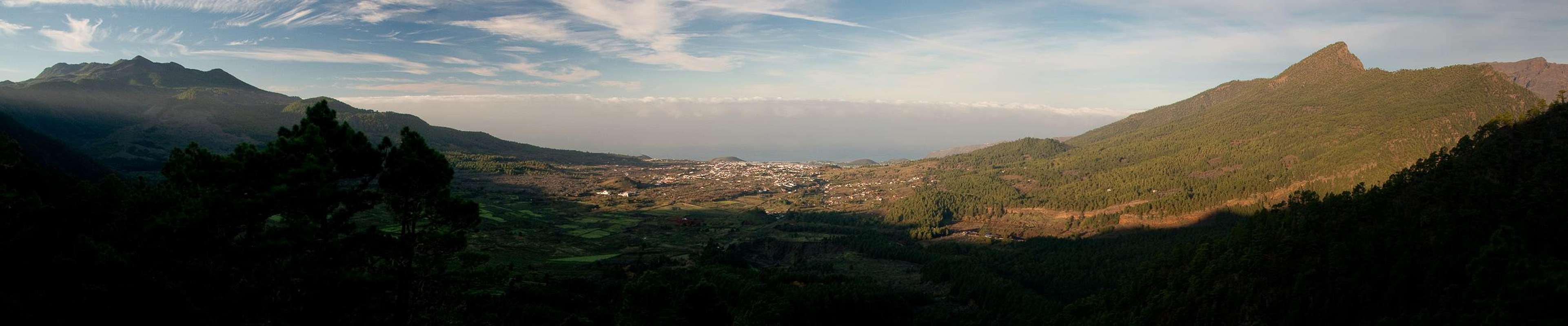
 Caldera de Taburiente with Cumbre Nueva to the right seen from Pico Birigoyo Caldera de Taburiente with Cumbre Nueva to the right seen from Pico Birigoyo |
Of La Palma's three mountain ranges, Cumbre Nueva is the central one, connecting Cumbre Vieja in the south with Caldera de Taburiente in the north. It gradually rises from little more than 1400m in the south to almost 2100m in the north where it culminates in Punta de los Roques before touching the caldera rim. Since it is - in most of its length - lower than the two encompassing ranges it constitutes the weather divide between the western and eastern parts of the island. Quite often a cloud cascade devepops across the lowest parts of the range.
On fine days, however, the Cumbre Nueva Ridge Hike is one of the most scenic tours on the island. It can be started in two different locations (see Getting There Section) which results in completely different types of hike. While the full traverse from Rifugio del Pilar is a mere stroll, the ascent from Ermita de la Virgen del Pino in the west is a strenuous hike along an old Camino Real.
On top the ridge hike follows broad road-like trails up to Pico Ovejas where it turns into a winding path which ultimately leads to Punta de los Roques. To reach this highpoint of Cumbre Nueva some easy UIAA II climbing is required.
Getting There
  |
As mentioned above, there are two trailheads for the Cumbre Nueva Ridge Route. They reach the ridge in two different locations.
- Refugio el Pilar: The saddle near the refugio is the lowest spot on Cumbre Nueva, from here a road leads along the ridge to Reventon Pass, after which it vanishes. Refugio el Pilar can be reached by leaving LP-3 right after the Cumbre Tunnel.
- Ermita de la Virgen del Pino: Take LP-3 through the Cumbre Tunnel up to El Paso. Follow the signs to the Visitor Centre of Caldera de Taburiente and La Cumbrecita. After about 1km turn to the right (east). There are signs for the Ermita which you will find at the end of the road.
Route Description
 |
- Start altitude: 930m (ermita de la Virgen del Pino), 1470 (Refugio el Pilar)
- Summit altitude: 2085m
- Prevailing exposition: W and E
- Type: 4h along well marked paths
- Protection: marked
Stage 1.1: Ermita de los Virgen del Pino to Reventon Pass
From the Ermita head out along a trail which at first resembles a potholed forest road. It leads through the beautiful pine forest between two field walls. After a while (30min) the "road" leaves to the right (south) while the trail turns into a cobblestoned Camino Real (King's Highway).
 |  |  |
The Camino Real steeply heads along a ridge towards Reventon Pass and often offers views towards the Cumbre Vieja Range in the south. Also Pico Bejenado to the south of the caldera can be perfectly seen. On Reventon Pass (little more than 1h) turn left (north) onto the Cumbre Nueva Ridge.
Stage 1.2: From Refugio el Pilar to Reventon Pass
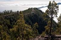
 Cumbre Nueva seen from the base of Pico Birigoyo
From the refugio hike to the saddle to its east where a dirt road turns off north. The road follows the Cumbre Nueva Ridgeline without many ups and downs, passing various summits to their eastern side. Some of these summits carry radio towers and the road is used as support road for these installations. It leads directly to Reventon Pass, where two routes join from the east and west. Take your time to enjoy the views of Aridane Valley in the west and the island capital Santa Cruz to the east.
Stage 2: From Reventon Pass to Pico Ovejas
 | 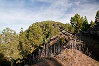 |  |
For a few metres the trail still resembles a dirt road before ending to the east of the ridgeline. Here the ridge pass starts heading to the top of the crest in two switchbacks. In general the following hike does not get overly steep, most of it is a leisurely stroll up the moderately ascending crest. In a few sections rocks have to be hiked across and here the trail gets steeper. Finally it heads out of the pine forest, just before Pico Ovejas appears on the left hand (western) side. The trail passes the summit but in a few steps you can get to the top. Views are a bit underwhelming because of the many pines which get in the way.(1h)
Stage 3: From Pico Ovejas to Pico Corralejo
 |  |  |
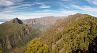
Turn back to the path and head northwards again. The pines draw closer at first but then start to vanish altogether. After 30min you reach the southern base of Pico Corralejo. While the crest trail passes the summit to the south and circles it in the west you can easily get to the top by following the broad east ridge. Here views are considerably more impressive than on Pico Ovejas with Caldera de Taburiente to the north and west and three Canary Islands (Tenerife, La Gomera and El Hierro) hovering around the Cumbre Vieja Range in the south.
Stage 4: From Pico Corralejo to Punta de los Roques
 |  |  |
The path bends to the west descending for about one hundred metres before it passes beneath the Pico Corralejo west face and turns north again. After a wide saddle a short scramble takes you to Refugio de la Punta de los Roques on the southern shoulder of the mountain itself. Punta de los Roques can be reached by a short scramble along brittle rock and offers wonderful views of Caldera de Taburiente.
 |