Short Version
Deerhorn to Stanford to Gregory's Monument to Caltech was a long day from Onion Valley, gaining about 12,600 vertical feet. I climbed Deerhorn from Vidette Creek via the direct 4th class ridge, returned to the base via the 3rd class ridge from the subpeak, climbed the north side of the Deerhorn saddle to Stanford's north ridge and Gregory's Monument, dropped down to the valley between Caltech and Erickson, climbed Caltech's west side, descended its southeast side to the JMT, followed the JMT to Kearsarge Pass, and returned to Onion Valley.
It would have been shorter by perhaps 2 to 2.5 hours if I had (1) not tried to get to the Deerhorn saddle directly via Deerhorn's south ridge, and (2) returned by University Pass. It would have been easier if I had chosen either the leftmost scree chute or Harrison pass when dropping down from Gregory's Monument.
Long Version
Why do we climb mountains? Because they're there. Why do we link them into epic days? Because they're there --
right there next to each other, far from the nearest trailhead. We're lazy. Looking at the upcoming peaks during this year's Sierra Challenge, it struck me that Deerhorn and Caltech were only an inch or so apart on my topo. Better yet, Stanford and Gregory's Monument, which I had failed to summit this spring, were right between the two challenge peaks. For efficiency's sake, then, I had no choice but climb them all at once; anything else would be too much work.
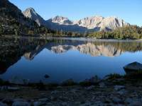
![Smoky dawn on Kearsarge]() Smoky dawn on Kearsarge Pass.
Smoky dawn on Kearsarge Pass. I set off with the surviving Challengers at 5 AM from a surprisingly windy and cold Onion Valley, wearing all my layers and packing a hearty supply of trail mix, pop-tarts, granola bars, and packaged fish. We passed a pair of glowing green eyes on the second switchback, then watched the sun rise red behind us as we shed layers and trudged up the switchbacks. I pulled slightly ahead as we climbed, reaching the summit in about 1:30, with Bob close behind and Adam arriving a minute or two later.
![Videttes and Deerhorn]() Videttes and Deerhorn from Bullfrog Lake.
Videttes and Deerhorn from Bullfrog Lake. After a shiver-and-snack break, we pounded down the newly re-graded and degraded rubble trail, then turned toward Bullfrog Lakes. The lakes reflected our first clear view of Deerhorn, flanked by the East and West Videttes. Along the way we picked up Karl, who had started a bit earlier, and lost the rest of our hard-won elevation on the way down to the junction at Vidette Meadow.
![Deerhorn]() Deerhorn and a fish-infested lake.
Deerhorn and a fish-infested lake. Bob found a stream crossing and a use trail near the junction with Vidette Creek, about a mile south on the JMT, and we started climbing again. As the sun finally hit us, I made the mistake of stopping to shed a layer, have a snack, and apply sunscreen. The others, having no need for such things, quickly pulled far ahead, and I began chasing them and the disappearing trail through the trees and brush along the creek. I passed Karl, then finally spied Bob and Adam near the bottom of a rightward slab ascending a cliff band. One hard slog up a slab-and-boulder shortcut later, and one hour after I lost them, I finally pulled even with them across a large lake teeming with fish.
![Deerhorn]() Bob and Adam at the base of the ridge.
Bob and Adam at the base of the ridge. We regrouped above a second, fishless lake, then climbed the slabs to our right to the boulder field around Deerhorn. The southern, class 4 ridge beckoned across the talus, and I arrived at the base a few minutes ahead of the others. The face below the ridge, with its class 3 steps mixed with short tougher sections, made for sustained and satisfying climbing.
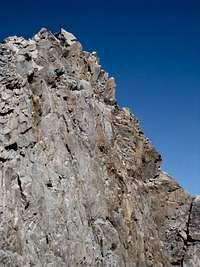
![Deerhorn summit]() Hand traverse and climb to Deerhorn's summit.
Hand traverse and climb to Deerhorn's summit. I gained the ridge for a short hand traverse and some class 4 climbing to the left, then followed it on to the summit, arriving around 10:40 AM. I found Michael in the register, as expected, as well as an adventurous soul who planned to splitboard the couloir between the two ridges.
![Deerhorn summit]() Bob and Adam on upper Deerhorn ridge.
Bob and Adam on upper Deerhorn ridge. While waiting for Bob and Adam, I had a snack and thought about my next move. The north slope of the Deerhorn saddle looked loose and wretched, and the climb had made me want more class 3-4 scrambling, so I decided to try the south ridge, figuring I could always drop down to the west if things got hairy. I made my way carefully south, moving between the ridge itself and the west face to avoid difficulties among the gendarmes and fins. The traverse was challenging but doable until the second-to-last gendarme, whose south side was sheer from the ridge far down into the western valley. I spotted a crack system near the ridge, but the difficulty and exposure were more than I wanted to try, so I opted to drop off the west side and climb back to the Deerhorn saddle from there. It couldn't be worse than the north side.
Tragically, my gully was blocked by cliffs beyond my downclimbing ability, so with heavy feet and bloody hands, I made my way back past Deerhorn (12:36 PM), where I re-signed the register to give SAR a hint, and down the northern class 3 ridge to the east. I spotted Bob and Adam on my way down, and the temptation to follow them back to Onion Valley was nearly overwhelming. Clearly, it was time to lie to myself.
"Self?"
"Yes?"
"Why not just try Stanford? You can drop down the East side and return through Center Basin afterward, and still get a bonus peak."
"You're not just tricking me into continuing to Caltech?"
"Of course not!"
"Duh, okay."
![Deerhorn saddle]() Deerhorn, south ridge, and saddle.
Deerhorn, south ridge, and saddle. Subterfuge complete, I contoured across the boulders and short drops -- I should have dropped down further -- to the base of the nasty-looking saddle. The climb was every bit as awful as it looked, but I reminded myself that I was "only going to Stanford," and clawed my way to the ridge. Stanford's north side is a boulder hop until just below the summit ridge, which is straightforward class 3, so persistence and music got me to the summit at 2:35 PM.
After signing (and bleeding on) the register, I continued south along the ridge, looking for the ramp/ledge to the east that leads to Gregory's Monument. The ramp was obvious, so I scaled it, made an exposed, balancy, and probably ill-advised move at the top, and soon found myself on Gregory's Monument (sans register, apparently) at 3:02 PM.
Now it was time to admit the lie. Rather than returning to the east face, I headed down the bouldery plateau to the southwest, away from home. Hoping to save time, instead of dropping west to Harrison Pass and circling back across the basin, I dropped off the southwest side of the plateau. Choosing a promising-looking scree chute, I soon found myself descending carefully down a steep dirt and rock gully that I worried I might be forced to reclimb when it ended in a cliff. My gully did indeed cliff out about 20-30 feet above the talus of the basin, but strong, carefully-chosen words and a more careful downclimb of some cracks to the right deposited me on class 2 terrain a short distance from Caltech's west side at 3:35 PM.
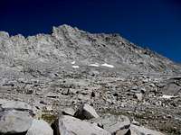
![Caltech west]() Caltech from the west.
Caltech from the west. The climb from this side was slabby and stable, and I would have enjoyed it earlier in the day. Now, though, it was a music-driven, aerobic threshold struggle to the summit, which I reached at 4:31 PM, panting and proud.
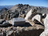
![The four-fer]() The four summits from Caltech.
The four summits from Caltech. But my joy turned to shock as I read Michael's register entry: "12h from Onion Valley via Deerhorn. Hi, Bob!" Another Challenger, it seems, was just as lazy as I, though I didn't fully understand the implications until the next morning. Since it was the last peak of the day, I sat down for my delicious fish and crackers, admiring Stanford and Deerhorn to the northwest, Williamson and Tyndall to the southeast, and the wall of the Kern Divide to the north. I was down to one pop-tart but, with no more peaks, I was "almost home."
![Forester Pass]() Switchbacks on south Forester Pass.
Switchbacks on south Forester Pass. I started down Caltech's loose southeast side around 4:40 PM, reaching the JMT about 40 minutes later, and settled into my trail-hiking stride with great relief. Forester pass is an impressive piece of engineering, with switchbacks built and blasted into the divide, leading to an improbable narrow gap. The 800 foot climb went by quickly on the well-maintained trail, and I was soon cruising down the ridge toward Center Peak, jogging some sections in an attempt to cut down on headlamp time.
![Junction Peak]() Sundown on Junction Peak.
Sundown on Junction Peak. The sun set on Junction Peak as I passed Center, and I opted for the longer, on-trail return via Kearsarge rather than the direct route over University Pass. Negotiating the boulders east of the pass at night would be tricky with my tiny headlamp, and I was tired of steep cross-country travel. A longer trail cruise seemed like the way to go.
![Kearsarge Pinnacles]() Sunset on Kearsarge Pinnacles.
Sunset on Kearsarge Pinnacles. As I walked and jogged along Bubbs Creek, watching the sun set on Kearsarge Pinnacles, I passed several parties of JMT hikers hanging laundry and gathering around their campfires. They probably wondered where the skinny guy in a day pack was headed at dusk, so far from any trailhead. For my part, I wondered if they had any spare calories for me. Promising myself a snack at the Vidette Meadow junction, I passed by with no more than a few envious glances.
I reached the junction at dusk, put on my headlamp, and dug into my pack for my treat. One empty wrapper; two empty wrappers; disaster! Had I misremembered? Frantic, I dug through the trash and warm clothes in my pack, and found the precious tart crushed between my shell and hat near the bottom. I cautiously lifted out the hat, held it near my mouth, and carefully ate the pieces, bits, and crumbs. Then I noticed a week's worth of nuts and crumbs at the bottom of my pack. I was tempted to upend the pack into my mouth, but settled for picking out some bits that could have come from today's pop-tart.
At least I had company on the moonless march back to Onion Valley: I passed two groups camping on the climb up from Vidette Meadow, then nearly stumbled into someone's tent near Bullfrog Lakes when I mistakenly followed a use trail to their campsite. I backtracked a bit, followed the paths heading most uphill, and was soon headed back up the pass, where I saw a light on the trail above me. More for company than for competition, I sped up the trail and caught what I knew must be another Challenger. This turned out to be (someone whose name I didn't catch), returning from Deerhorn after twisting his ankle. We started talking and, sooner than I expected reached the summit of Kearsarge Pass.
My concern for his twisted ankle quickly lost the fight with my desire to lie down, and I slowly pulled away on the descent, stumbling down the trail with my dim lamp and dead legs. I finally reached the parking lot at 11:10 PM, forced myself to eat a few things, crawled into my bag, and slept the sleep of the just -- the just too tired to think of tomorrow.


Comments
Post a Comment