TR Devil's Head - West Ridge 5.4
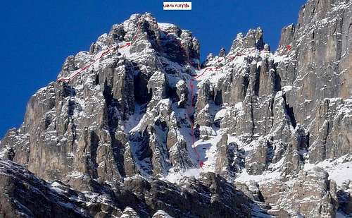
Overview of routes on West Ridge
![Devil s Head Route Overview]()
Devil’s Head did not go easily for us as we made several scouting trips and two serious attempts before we finally succeeded on our third try. We had decided to do the complete West ridge route versus the South gullies because we had heard the ridge was more interesting climbing and that the south gullies were apparently complicated, steep and very loose. At this time(1998) there were no decent pictures or route descriptions. The Rocky Mountains of Canada – South (aka little green bible) had a very cursory description of the original 1925 ascent. Basically ascend the West ridge and that the going was thin in places and the rock was very coarse.
We decided to go in by Malamute Valley which is on the West side of Devil’s Head because of cliffs on the East and South side of the lower mountain and that was original approach route. Note there now is a trail that goes up a break in the cliffs on the SE side of the mountain by the Valley of the Birds. Malamute Valley is named for Al Dunham’s Malamute dog and all of the first ascent ice climbs that were done by Al and friends in the valley have names that are references to dogs.
On our first try we followed faint trails and cairns up the convoluted West Ridge but ran out of time before we discovered the best route out of four options up to the West summit. On our second try we reached the West summit as the clouds and a storm rolled in and we only caught glimpses of the main summit before we bailed. The third successful trip went as follows:
After crossing the North Ghost river 5 times you eventually you cross a stream coming in from Malamute valley which runs N-S on the west side of DH. Malamute valley trail is about 5 km after first river crossing and the trail is on the west side of the stream that you cross that runs out of Malamute valley.
The river crossings are normally 2 feet deep or less by late summer but they are deeper later in the day or if it rains. We used trikes on the second and third ascents and had problems such as floating down the river until we could hit a sand bar to get out. On the last trip on the way in, my trike floated and then rolled and it drowned/died. We left it beside the river and then dragged it through the river on the way out.
The river crossings are not marked and the trail is hard to follow. Some bits of old road some useful, but some are not as they lead nowhere. There are lots of old 4x4 tracks but they are easy to lose on the gravel bars. First two crossings are deepest and to south side of valley, the next is in the middle with a poor angle - drive in right side of river beside the right bank then angle left when forced into deeper water and aim upriver for shallower gravel beds. Stick to gravel beds for .5 km till trail leads to old road in trees to left. Next crossing is also in middle of valley but better to go to right and then hit old road in trees. Note that this is all now Park or Wilderness area and motorized vehicles are no longer allowed.
We camped at the end of the trail into Malamute valley.
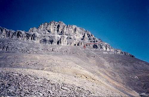
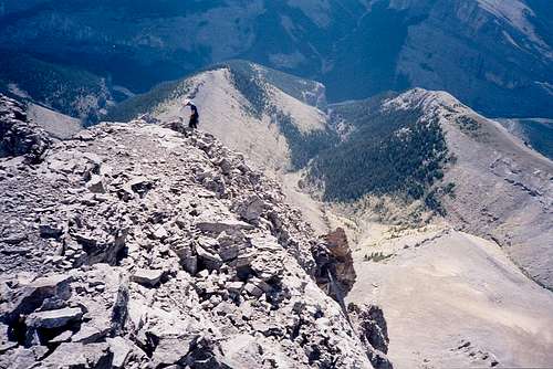
We got up a 4 AM and traveled 30 minutes along valley floor and then up the left side of a small drainage(put a small cairn on a big rock) on the East side of the valley and soon hit bits of trail in the scree. After the trees we left what seemed like a descent trail and angled to the left to a small ridge to avoid the scree. We topped out on a main ridge which leads up to base of the walls on the upper part of the mountain on the SW side of the West ridge of DH. A climbers trail led to low spot or weakness in first wall. There is a faint trail that comes around from the north side and which heads East along the South side of DH. This trail from the West would also provide access to the steep South scree gully route which is now mainly accessed from the SE.
The West Ridge from the SW.
![Devil s Head approaching West Ridge]()
We scrambled up a loose gully/chimney in the first wall for 15 - 20 m to a large sloping ledge covered in rubble. Traverse right on a faint trail and around 100 m and up 5-10 m on a low angle slab to another rubble ledge. Move around right until it opens up to left and up 60 m to base of buttress which has a small 2 inch by 10 inch steel memorial plaque? Somebody apparently only got this far in 1987 and put the plaque at their high point.
There were at least four ways to go. To the left is a 5.5 friction ledge which leads to an ugly loose chimney which we followed part way on our first try but it is longer and not necessary, despite cairn. The best route is to go right around a buttress and across angled scree slopes and up to base of a larger chimney alongside a towering right-hand wall. The smaller chimney to the left leads to harder face climbing and is the rappel route. The neat window in the wall to the right gives a good view of the main peak but leads down to downsloping slabby ledges with no protection.
The main chimney has a 3-4 m 5.4 section which is part body jam with one hand and foot on the smooth right wall which is similar to moves on lower chimney which leads to Un-named(Pumpkin) and Kings Chimney on Yamnuska. The angle eases off and you intersect with the high point of the West ridge which is the West Summit.
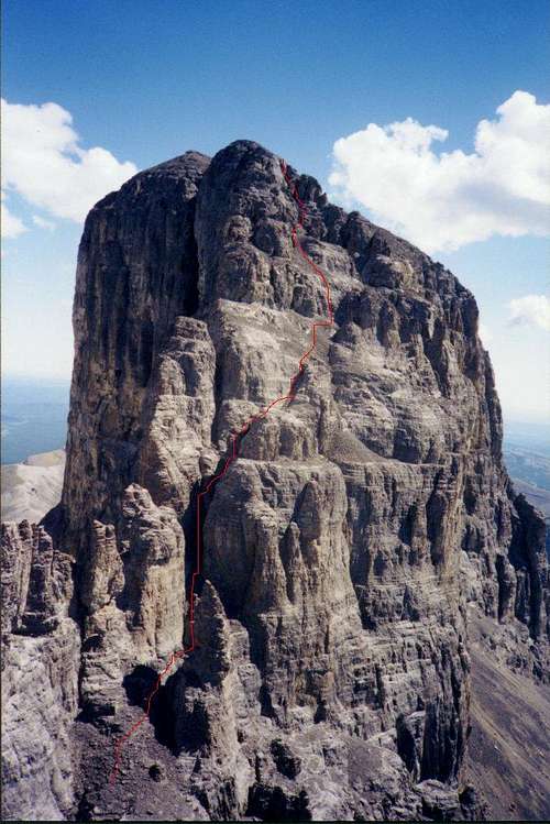
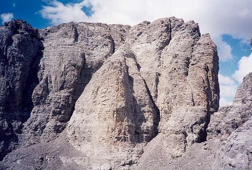
The view of the main peak is stunning as the west ridge drops 50 m (150 feet) and degrades into 20 to 40 m pinnacles which lead to the main summit block which has a complicated face, vertical sides and is 150 – 200 m higher. Take a good look at this because it looks different with your face up against it. Note the single 25 m pinnacle to the right away from the main ridge as you will go between it and the others. On the main face, the chimney that leans right is the one you want for the lower half.
The west side of the main summit with route marked.
![Devil s Head - main summit route]()
We scrambled down on loose rubble to the top of a buttress between the main west ridge and the side ridge we came up. As we looked down to the saddle, there was a chimney on each side of this buttress and we chose the left one because of a rappel sling on a horn. We rapped down 30 m to base of the chimney which put us on a rubble ledge at the base of the pinnacles. You need to climb this chimney to get back out and it had some 5.3 to 5.4 moves in it and no protection.
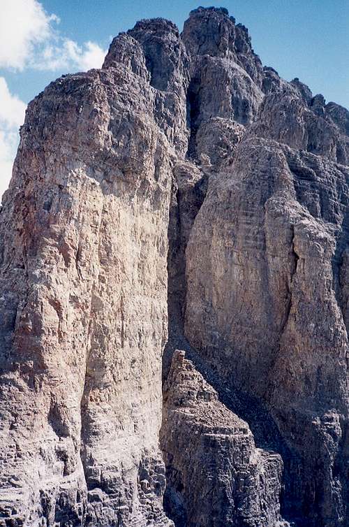
Move 70 m across the rubble and past the top of the steep narrow gullies which come in from the South, to a gully the leads up to the saddle between the isolated pinnacle and the main ridge. We went over the saddle (cairn) and across ledges to a gully up to left that leads to base of two chimney systems.
Looking up at chimneys in Main Summit from the saddle.
![Devil s Head- main summit from Saddle]()
Right hand one has partly overhanging chockstone at 4 -5 m but it is the one because you can see a chained rappel station up on the right-hand wall above the chockstone. We climbed left chimney for 3-4 m and then traversed on face around to above chockstone(5.3/5.4 and no protection). Climb up for 30 m to where chimney splits. Left chimney leads up to very exposed face climbing ( old sling) but better to continue up right one which leads to the same large sloping rubble ledge. There was a cairn which we marked with flagging tape to mark the top of this chimney for later.
We angled up right 70 – 100 m up to base of next wall which has options but we moved right along wall past a small pinnacle and around for 30 m to an easier spot on the wall. Face climb the wall 5.3/5.4 angling up left for 10 m to a ledge. We also marked this as it was hard to see where to start down climbing on the way down. Move right and up a loose gully which goes left then right and up onto easier ground which is the summit ridge (cairn).
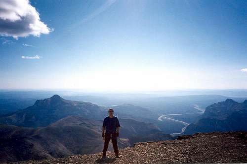
Walk 200m to the summit cairn and enjoy the view which includes the Calgary office buildings on the horizon. The register had two groups in 1998 but we were the first in 1999. Given the length of access and the river crossings I was not surprised.
View East from Summit - Calgary lost in the haze.
![Looking East from Summit]()
It took us five and 1/2 hours up from camp without using rope except for rap along ridge. The descent was four and 1/2 hours out to camp spot as we had to carefully downclimb everything except the lower part of the chockstone chimney (short rap) and then climb up west ridge and rap off it.
West Summit from saddle on the way out. We climbed back up the RH of the two left leaning chimneys.(5.3/5.4 with no protection)
Preparing to rap off the SW corner of the West summit. The North Ghost River Valley is in the background. The winter access is up ice climbs in the side valley to the right.
![Rap on Descent of West Summit]()
We looked down the steep South gullies at the saddle but they looked really loose and we couldn’t be sure that we would find the right ones that went all the way to the base of the upper mountain.
The river crossings were tough on the way out as we took turns riding the quad and wading to our waist. We had to drag the drowned trike through the last river crossing and manhandle it into the trailer which made for a very long hard day.
We felt a big sense of accomplishment to have finally solved the complicated West ridge and beat the difficult access. Devil’s Head is a well known and historic mountain and is a very coveted peak despite its’ lowly elevation. If you ask a non climber on the streets of Calgary to name some mountains, the list for most would be Banded Peak, Devil’s Head, the Three Sisters and maybe Moose Mountain or Temple.


Comments
Post a Comment