
-
 12711 Hits
-
 88.19% Score
-
 26 Votes
|
|
Mountain/Rock |
|---|---|
|
|
39.69420°N / 105.2002°W |
|
|
Jefferson |
|
|
Hiking |
|
|
Spring, Summer, Fall, Winter |
|
|
6660 ft / 2030 m |
|
|
Overview
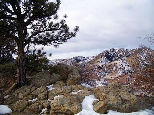 SW from Dinosaur Ridge
West of Denver rises the hogback, a long north-south running ridgeline of up-thrust rock. The hogback forms a somewhat scenic backdrop for the western suburbs of the Denver metro area. One section of this hogback is known as Dinosaur Ridge. This neat little peak features a scenic, rambling ridgeline and great views of Green Mountain to the east and Mount Morrison to the west. Stunted pines dot the ridge top, but views are plentiful.
As if the pleasant hiking and enjoyable views were not enough, the hogback holds much for those interested in geology, including loose plate-like sheets of shale, as well as sandstone rippled by ancient waters or sculpted by more modern winds. But you figured Dinosaur Ridge got its name somehow. Indeed, this nifty little mountain holds other surprises: Ancient dinosaur tracks and the bones of these long-gone, giant lizards. This would be a dynamite summit for families or out-of-town guests.
Colorado Rank: Dinosaur Ridge is a soft ranked peak*
Prominence: 280 feet
USGS Quad: Morrison
Recreation Map: #100 Boulder / Golden
Rank & Prominence: Lists of John
*In a nutshell, soft ranked peaks lacks 300 feet of confirmed gain from the saddle with their highest neighbor. However, if their optimistic prominence proves true, they would be ranked peaks. But let’s not get bogged down in the details here.
Getting There & Route Information
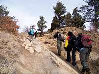 Hiking through sandstone
 Heading north along ridge
Dinosaur Ridge can be accessed via several access locations.
East: The Dinosaur Ridge Visitor Center is located west of the Alameda Parkway exit off C-470. Detailed instructions to the visitor center can be found here.
West: There are also trailhead options off of I-70 via County Hwy 93. This Matthews / Winters Park map illustrates numerous trailhead options.
Exactly how you want to reach the top of Dinosaur Ridge and how long you want to walk is up to you. The dinosaur track site is located on the lower east side of the ridge. The summit of Dinosaur Ridge is near the far northern end of the formation. Anticipate sharing your route with other hikers as well as mountain bikers.
Red Tape
 Dinosaur Ridge from Mount Glennon
Photo by Jeremy Hakes
 Dinosaur Ridge from Mount Glennon
Photo by Jeremy Hakes
 Loose shale
 About the track makers
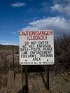
Observe all posted signs and do not mar, deface or touch the dinosaur tracks or any fossils encountered. Most of Dinosaur Ridge is contained within Matthews / Winters Park, a Jefferson County Open Space.
While JeffCo has indeed developed one of the premier county open space systems in the country, your use of these open spaces is governed by tons of red tape. It is your responsibility to know the rules and regulations before visiting this open space.
And here, for reference, are the standard rules governing use of Jefferson County Open Spaces:
• Follow use regulations (biking vs. hiking)
• Dogs must be on a leash; pick up after your pet
• No fires
• No camping
• Motorized vehicles prohibited
• No feeding wildlife
• Adhere to posted Park closures
• Open carrying of firearms is prohibited
• Park is open one hour before sunrise to one hour after sunset
Full Jefferson County Open Space Regulations
 |
 |
 |

Camping
 Geologic Striations
Photo by Jeremy Hakes
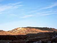
 Mount Morrison from Dinosaur Ridge
There is no camping available in Matthews / Winters Open Space. This little mountain is highly accessible to residents of and visitors to Denver and other Front Range cities from Fort Collins to the north to Colorado Springs in the south. Few will need overnight lodging for this peak.
Weather & Seasons
 South along ridgeline
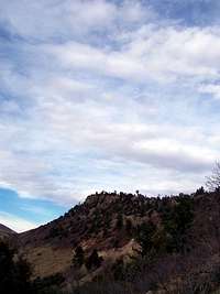 North from below the ridge
While Dinosaur Ridge makes for a great outing any time of year, take note that summers could be hot and crowded. This is a great peak to reserve for snow-season days when it’s just too cold and nasty in the high country or when avalanche danger is unreasonable.
External Articles & Additional Information
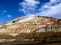
 A roadcut through the north end of the formation shows the strata, from the Apex Trail.
 Curving Hogback
Front Range Living
Dinosaur Ridge: The Dinosaur Highway
Dinosaur Ridge
Dinosaur Ridge Trail
Morrison Natural History Museum (Thanks, Jeremy)
The Thunder Valley Motocross track occupies the land immediately to the east of Dinosaur Ridge.
Jeremy Hakes - Mar 1, 2011 4:38 pm - Voted 10/10
Dinosaur Biking!Dinosaur Ridge is almost certainly the most technically difficult trail in Jefferson County, indeed, the entire Front Range. Expect to see mountain bikers suffering and falling while hiking the area.
Sarah Simon - Mar 14, 2011 11:07 pm - Hasn't voted
Re: Dinosaur Biking!Sounds like a serious opportunity for some helmet-cam. Are you volunteering??? -Sarah