
|
|
Area/Range |
|---|---|
|
|
32.45532°N / 106.79911°W |
|
|
5835 ft / 1779 m |
|
|
Overview


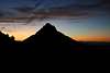
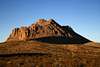
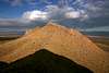
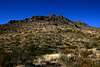
The Doña Ana Mountains are an isolated cluster of peaks located about five miles north of Las Cruces, New Mexico on the Rio Grande flood plain. The land encompassing these mountains has been designated as an Area of Critical Environmental Concern (ACEC) and is administered by the Bureau of Land Management. Elevation in the range varies from about 4,000 feet to over 5,800 feet.
The mountain range can be divided into three physiographic sections. To the north, low limestone ridges, hogbacks and cuestas are surmounted by high monzonite peaks, named Summerford Mountain. The steep, narrow mountain dominates the surrounding landscape, rising sharply 1,300 feet from the desert floor. The central part of the range comprises a maze of low rounded hills containing arroyo systems. The southern one-third of the range contains pyramidal peaks of monzonite porphyry, including Doña Ana Peak, which rises 1,480 feet from the surrounding bolson plains. With an elevation of 5,835 feet, Doña Ana Peak and Summerford Mountain West (same elevation, to the north), are the highest points in the range.
State lands surround much of the ACEC to the north, west, and south in the form of New Mexico State University’s Chihuahuan Desert Rangeland Research Center (CDRRC), also known as the College Ranch, and administered by the NMSU Board of Regents. The CDRRC, established in 1927 for educational, research and experimental development purposes, now encompasses 100 square miles. Also close to the borders of the ACEC lies the Jornada Experimental Range, administered by the U.S. Department of Agriculture, just to the northeast.
Wildlife in and around the Doña Ana Mountains include the mule deer, pronghorn antelope, gemsbok, mountain lion, bobcat, coyote, badger, and fox. Bird species include the golden eagle, hawk, and roadrunner.
Summits In the Range
| Image | Peak | Section | Elevation | Prominence | Latitude | Longitude |
|---|---|---|---|---|---|---|
 |
Doña Ana Peak | Southern | 5,835' | 1,480' | 32.45413 N | 106.78874 W |
 |
Summerford Mountain West | Northern | 5,835' | 1,165' | 32.5133 N | 106.8201 W |
 |
Point 5833 | Southern | 5,833' | 503' | 32.45770 N | 106.78290 W |
| NO IMAGE | Summerford Mountain East | Northern | 5,754' | 319' | 32.5114 N | 106.8104 W |
 |
Point 5710 | Southern | 5,710' | 560' | 32.45940 N | 106.79680 W |
| NO IMAGE | Point 5485 | Northern | 5,485' | 590' | 32.5081 N | 106.8285 W |
 |
Point 5450 A | Central | 5,450' | 720' | 32.4839 N | 106.7954 W |
 |
Point 5350 A | Central | 5,350' | 600' | 32.4782 N | 106.8019 W |
 |
Point 5315 | Central | 5,315' | 345' | 32.47486 N | 106.80727 W |
 |
Point 5130 | Southern | 5,130' | 340' | 32.4699 N | 106.7708 W |
 |
Point 5103 | Central | 5,103' | 413' | 32.46554 N | 106.81747 W |
Getting There
From I-25 in Las Cruces, take US Hwy 70 east for about 3.5 miles. Take the Mesa Grande Drive exit and stay in the left lane as the off-ramp merges with the eastbound frontage road that runs parallel to the highway. When the off-ramp widens further to the left with another lane, go the far left lane as this will allow you to make a U-turn underneath the Hwy 70 overpass just before Mesa Grande Drive. After making the U-turn, you will now be on the westbound frontage road that runs parallel with the highway on the north side. After going about 0.75 miles on the westbound frontage road, turn left onto North Jornada Road and proceed north. After about 1.5 miles, Jornada will go from asphalt to grated gravel. Continue north on Jornada for 5 more miles, then turn left onto County Road D-063; there will be a sign for the Chihuahuan Desert Nature Park at this turn. After going 0.55 miles, you will see the Chihuahuan Desert Nature Park to your left. Continue west to the Doña Ana Mountains, which you will see directly ahead of you. As a point of reference, you will have to go about 2.1 miles from the Nature Park to reach the left turnoff that leads south towards Doña Ana Peak, or you can bypass the turnoff and continue west to access other areas of the range.
NOTE: The Chihuahuan Desert Nature Park is accessible via 2WD. Use extreme caution if proceeding beyond this point in a 2WD vehicle -- there are some areas that are not passable with 2WD.

Camping
Camping is permitted in the area. There are no developed campsites or facilities.
Red Tape
No fees. BLM rules apply. Remember to leave no trace. Accessible 24 hours a day.
Food & Lodging
If you travel from out of the area to get to Las Cruces, make sure you take advantage of the authentic Mexican food served at the many restaurants that abound here. The Mexican food in and around Las Cruces is the best you will find outside of Mexico – it is the real deal.
I recommend the restaurant La Posta in historic Old Mesilla, just outside of Las Cruces to the west. La Posta itself is located in the same building that served as a stop on the Butterfield Overland Mail and Stagecoach Line between 1859-1861. It sits on the edge of the Mesilla Plaza, where, in 1853, the American flag was first raised following the signing of the Gadsden Purchase. The old courthouse where Billy the Kid was tried and sentenced to hang in 1881 is directly across the street from La Posta. Authentic Mexican food at a fair price in a historic atmosphere add up to a truly unique dining experience.
Las Cruces offers a wide selection of hotels and motels to fit any budget. Reference the link below for a list of hotels, motels, bed & breakfasts, and RV parks.
Las Cruces Convention & Visitors Bureau - Lodging