The Prologue
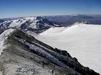
![Hualca Hualca and Sabancaya From the Summit of Ampato]() Hualca Hualca and Sabancaya From the Summit of Ampato
Hualca Hualca and Sabancaya From the Summit of Ampato![Hualca Hualca, False Summit on Sabanca and the Crater]() False Summit and the Crater on Sabanca
False Summit and the Crater on Sabanca![The Almost Covered Sign]() The Almost Covered Sign
The Almost Covered Sign![A Piece of Wood Near the Summit of Ampato]() A Piece of Wood Near the Summit of Ampato
A Piece of Wood Near the Summit of Ampato
I had a DNS hanging over my Nevado
Ampato climb for seven months, so when Tim said he wanted to climb Ampato, as well as possibly Sabancaya and Hualca Hualca, I was eager to join him. A couple of days after our
Chachani climb, we loaded up my van and after a few last minute purchases, headed out on the Chivay road at about 7:20 am. It was a beautiful sunny winter day here, and as soon as we got around Chachani we got our first view of Ampato in the distance. Unfortunately with all the canyons and mountains in between us, it is over a five-hour drive to get to the mountain, which is less than 50 miles from Arequipa. The road is good until the Puno turnoff, and then it is a mixture of bad pavement, gravel and construction most of the rest of the way. It has been recently paved for the last part, just before the Patapampa turnoff.
After stopping by the cemetery to add some kerosene to the fuel tank, we arrived at the 16,540' base camp in the early afternoon. I decided to sleep in the van but Tim set up his tent in one of the nice campsites there. As soon as the sun went down behind the mountains at about 4:15, it really began to get cold, so we started on an early dinner. I have been making grilled cheese sandwiches on the trails and mountains lately, using a small light fry pan. I had just bought a large fry pan to speed up the process with more than one person, and was trying it for the first time that evening. It held all eight (small) sandwiches but with the cold and a little wind, it made a better radiator than a fry pan, it wouldn't get hot enough. On Chachani we had used just my alcohol stove but as long as we could drive to base camp here, Tim brought his multi-fuel MSR stove as well. That soon got them toasty and we enjoyed a hot meal of grilled sandwiches, instant mashed potatoes (with more cheese) and tea.
Ampato
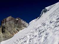
![Our Route Up the Snow on the Right]() Our Route Up the Snow on the Right
Our Route Up the Snow on the Right![Tim Near the Glacier]() Tim Near the Glacier
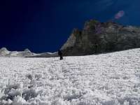
Tim Near the Glacier![Checking Out the Climb to the Summit Ridge]() Checking Out the Climb to the Summit Ridge
Checking Out the Climb to the Summit Ridge![Almost to the Lower Part of the Ridge]() Almost to the Lower Part of the Ridge
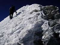
Almost to the Lower Part of the Ridge![The Snow Made the Last Climb Easy]() The Snow Made the Last Climb Easy
The Snow Made the Last Climb Easy![Coming Up the Last Step]() Coming Up the Last Step
Coming Up the Last Step
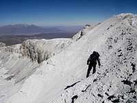
We talked about doing Sabancaya first as a warm up, but because Ampato was our main objective, we decided to do that first and then attempt the others. In the morning it was about 15°F so the just risen sun felt good as we started up the mountain at 6:30. On my previous attempt in December, we had stayed down in a valley until we reached the glacier, but as there was snow now we went high to the right side on the snow as soon as possible. It turned out to be a good route, the snow was just right to give a good grip for crampons, but not soft enough for post holing in most cases, and the penitentes on the glacier weren't as bad as in December. The added snow above the glacier also made it possible to go straight up the steep slope just to the left of the summit plateau, rather than having to go way off to the left and traverse back along the ridge. There was a bit of mostly frozen gravel right near the top of the ridge, which made me a bit nervous, but Tim showed me the way up that and we arrived at the ridge at 1:55 pm.
In December the final climb to the summit was a fourth class scramble, but now it was an easy climb up the backside on good snow. At 2:00 pm we were enjoying the views from the summit, especially of Sabancaya and Hualca Hualca. We didn't see any signs of
Juanita's friends but did see one piece of wood that obviously had been carried up there, as well as a modern marker sign just below the summit step. The descent on the gravel was a bit trickier, but again Tim talked me down step by step and we were soon in the snow and then back down to the glacier. This time my feet were fine in my new High Tech insulated boots, but Tim had gotten snow in one of his plastic boots and had a very cold foot, so he headed down quickly trying to get to the tent before the sunset. Going down I realized just how steep the route was, and being a bit tired, took it very slow and cautious on the descent being it was only my forth time on crampons. I arrived at camp about a half hour after Tim, and we had a repeat of the previous night's dinner.
If you like solitude and want to get away from the crowd, this is a good place to go. There were some older tire tracks still visible going up to base camp, but we had the camp and both mountains all to ourselves. The stars were beautiful and could even see a little bit of the lights of Arequipa, off to the right of Chachani. The only disruption was when the wind blew my spare gas can across the bars on the roof rack in the middle of the night - It sounded like the mountain had fallen on the van!
![Going Down the Frozen Gravel Slope]() Going Down the Frozen Gravel Slope
Going Down the Frozen Gravel SlopeSabancaya
![Going Up Through the Rocks]() Going Up Through the Rocks
Going Up Through the Rocks![We Went Up the Snow on the Right]() We Went Up the Snow on the Right
We Went Up the Snow on the Right![A Bit Icy In Spots]() A Bit Icy In Spots
A Bit Icy In Spots![Penitentes on Sabancaya]() Penitentes
Penitentes![Traverse on the Crater Rim]() Traverse on the Crater Rim
Traverse on the Crater Rim![Going Carefully on the Rim]() Going Carefully on the Rim
Going Carefully on the Rim
Expecting an easier and shorter day climbing Sabancaya, the next morning we slept in until the sun came up at about 6:20, and didn't start hiking until 7:30. Tim led the way cross-country to the small canyon, and then as he answered nature's call, I found a route up through the rocks to the sandy bowl, just before we reached the snow level. At 10:30 we had our crampons on and were again taking the snow route up, although there was bare sand on the other side of the shallow gully if someone would prefer that. Out route plans changed as we went and soon we were zigzagging up the most direct route instead of taking a gentler traverse off to the right of some crevasses, as earlier planned. The penitentes weren't too bad, but were worse than on Ampato, and we also hit some ice, which made for a better photo than climbing route.
By 1:00 pm, Tim was traversing up the crater rim to the true summit, after reaching what, as we had expected, was a false summit. At first I was glad the true summit was off to the left, as the peak to the right looked like it was farther away. However I soon changed my mind when I hit a section of the sharp sandy rim where it wasn't possible to walk on the top of the rim, or on the outside of the crater, but only on the steep, loose inside of the crater. The one-foot diameter rock that went careening down into the mouth of the crater was an unneeded reminder to be extra careful! My sideways crabwalk, with one hand and my ice axe hooked over the sharp rim of the crater took extra time, and I arrived on the summit at 1:27 pm, about 10 minutes after Tim. Here we got a good look at the steep pointy summit rock of Hualca Hualca, which John Bigger describes in his book as of "unknown" difficulty. We decided to pass on climbing that this time as it appears that the best approach for it would be from either Cabana Conde or Pinchollo, villages in the
Colca Canyon.
I did better on the return, both on the crater rim and on the descent down the snow, although we both slid down the sand for quite a ways. I also stayed on the sand down lower, instead of going over to the snow, which seemed like the quicker way down. This time I was trying to get to the camp before sunset, or actually to the van. It doesn't like to start at cold high altitudes, so was hoping to get down while it was still warmed by the sun. I made it at about 10 minutes after sunset, but even that was too late. It sounded real close to starting but just wouldn't keep going when I released the starter. So, we spent another night at the base camp instead of going down to the refuge, and in the morning slept in even later. After breaking camp we coasted down the mountain to about 1500 feet lower elevation and at 10:00 AM were able to get the van started. On the way back to Arequipa we stopped at the Interpretive Center, which wasn't open on the way to Ampato. We arrived in Arequipa before dark and immediately went to my favorite Pollo ala Brasa (roast chicken) place and enjoyed a good meal.


Comments
Post a Comment