Double Routes on Ward Mountain
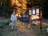
![Camas Lakes Trailhead]() Camas Lakes Trailhead
Camas Lakes Trailhead
Route Elevation Gain – 3,964’
Distance – 12.1 miles
Difficulty – Class 3
Ascent Date – 24sep06
Total Route Time – 8 hours
![Camas Trail into Woods]() Trail takes a hard left into thick forest cover.
Trail takes a hard left into thick forest cover.
I can’t remember exactly when I first decided I wanted to do a point-to-point outing beginning at the Camas Lakes Trailhead, into the Camas Cirque, up Ward Mountain’s west ridge to its summit, then down Ward’s “standard” East Face Trail to the trailhead. I’d studied the topo maps and decided the chances of making it up the west ridge were good, but knew you can never assume what shows on a map is what exists “on the ground.” Still, it looked like it was worth a chance, so when I finally got the opportunity on Sunday, September 24, 2006, I went for it, solo.
![Camas Creek Bridge]() First bridge over Camas Creek.
First bridge over Camas Creek.
7:45 am – Having left my truck at Ward’s standard trailhead the evening before and knowing it would be a fairly long day, my wife, Linda, dropped me off for an early start from the Camas Lakes Trailhead. It was a little chilly, so I wore a fleece pullover and gloves as I hiked northward along the mostly level trail.
![Kidney Lake Trail]() Cutoff to Kidney Lake is on the left.
Cutoff to Kidney Lake is on the left.
8:20 am – I reached the 1 mile mark where the trail makes a sharp left turn to the northwest and enters a thick woods as it begins to ascend more steeply. I shed the fleece!
8:35 am – At a point about 2.25 miles from the trailhead, was the first bridge over Camas Creek. As the sun was still close to the horizon, there wasn’t enough available light to get a good picture. I had to use my flash.
8:50 am – The point where the cutoff to Kidney Lake goes to the left (south), I stopped to take another picture. I was almost disappointed I wasn’t including Kidney Lake in my route that day, it’s such a great place.
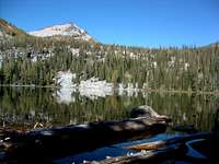
![Talus Field @ Lower Camas Lake]() Talus field at the northwest corner of Lower Camas Lake.
Talus field at the northwest corner of Lower Camas Lake.
9:00 am – Lower Camas Lake came into view. I was more than warm enough to zip off the lower legs on my pants and did. I was so sweaty, I decided I should have taken them off back at the bridge. Oh well, next time…
9:20 am – I’d passed the talus at the northwest corner of Lower Camas and had reached a couple of the really ornate cairns which mark the trail to Middle Camas Lake. Someone spent some time and must have had serious fun building these.
![Ornate Cairns]() Ornate cairns.
Ornate cairns.
9:35 am – At Middle Camas I took time for a few pictures of Point 8766 southwest of the lake. It looked pretty neat with its dusting of snow and flanks showing scattered larch in fall color.
![East Camas Peak from Middle Camas Lake]() Point 8766 looks over Middle Camas Lake.
Point 8766 looks over Middle Camas Lake.
9:45 am – Close to the west end of Middle Camas, I stopped again to take a picture of Camas Peak
(Point 8904). The morning light was just too good to pass up.
10:20 am – Having decided I’d been spending too much time taking pictures, I didn’t stop again until I’d almost reached the saddle on the north rim of the Camas Cirque, about 4.75 miles from the trailhead. It seemed like the best place for a picture which would show most of the west ridge to Ward’s summit.
10:35 am – Now on the saddle, I took more pictures, this time of Camas Peak and Point 8934.
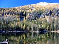
![East Camas Peak from Upper Camas Lake]() Camas Peak from Upper Camas Lake.
Camas Peak from Upper Camas Lake.
10:45 am – Only 10 minutes later and a little higher on the ridgeline, I stopped again for a couple of shots of Points 8874 and 8799. I also got a few of the rugged west side of the north buttress leading to Point 8765 along Ward’s west ridge. The fall color of the larch wasn’t bad either.
11:25 am – Now high enough on the ridge for some really good views, I studied El Capitan plus Koch and Whites Mountains to the south. The dusting of snow on all the peaks made the ridgelines really stand out.
![Ward s West Ridge]() Ward's west ridge.
Ward's west ridge.
11:50 am – By now I had successfully managed to find good routes around the rugged rock close to Point 8765 and stopped to look back west toward the rather interesting outcroppings.
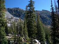
![Ridge Near Point 8765]() Looking west at rock outcroppings near Point 8765.
Looking west at rock outcroppings near Point 8765.
From this point to the summit is a comparatively easy scramble up talus, though there are a few spots along the crest of the ridge with so much plant growth
(mostly larch and whitebark pine) that the branches kept trying to rip the pack from my back.
![Como Peaks from Ward Summit]() Como Peaks from Ward's summit.
Como Peaks from Ward's summit.
Additionally, I’d discovered that the dusting of snow had made the rocks slippery in spots, especially where it had begun to melt. Even though there is no “real” exposure on this route, I found that to keep from slipping I had to slow my normal pace and be careful where I placed my feet and hands.
![Bob & Warrick]() Bob & Warrick, a couple of really tough ridders.
Bob & Warrick, a couple of really tough ridders.
12:30 pm – On the summit, I began taking pictures of whatever interested me, mostly the surrounding peaks. There are some interesting artifacts on Ward’s summit, including the remains of old lookout towers.
![Pintlers from Ward Trail]() Pintlers as seen from the standard Ward trail.
Pintlers as seen from the standard Ward trail.
1:05 pm – Just as I was ready to leave a couple of my friends rode into view on their mountain bikes. They’d ridden up the standard trail, a very serious effort that few can manage
(4,985’ of elevation gain over 6.2 miles). I delayed my departure from the summit to take their picture.
![Upper Burn Area]() Trail through the upper burn.
Trail through the upper burn.
1:30 pm – A few minutes down the trail I stopped once again to take pictures of the trail, the fall color, and the snow-covered Pintlers far to the east. Very impressive!
![Raven Rocks Overlook]() Rocks at the Ward Overlook.
Rocks at the Ward Overlook.
2:00 pm – I’d reached the upper portions of the burn
(from fires sometime before 1995) and could see the area is recovering nicely.
![Lower Burn Area]() Trail through the lower burn.
Trail through the lower burn.
2:15 pm – Almost 4 miles from the standard Ward Trailhead, the Ward Overlook is an interesting outcropping of rock along the northern edge of the east face. It affords one good views into the Roaring Lion Drainage plus Goat and Downing Mountains to the north.
![Ward Mountain Trail]() The beginning of the standard trail to Ward's summit.
The beginning of the standard trail to Ward's summit.
2:30 pm – I was once again into a burned area, this time the lower burn. After a couple of pictures, I decided it was time to put the camera away until I reached the trailhead and try to cover ground a little more quickly.
3:45 pm – My truck was right where I left it the evening before. Now to see if the cooler had kept my apple and Pepsi One cold overnight. Yep, it did! Very refreshing…
Route Statistics
![3D Topo of Camas Cirque Route]() 3D Topo of West Ridge Route. 3D Topo of West Ridge Route. |
![3D Topo of Standard Ward Route]() 3D Topo of East Face Route. 3D Topo of East Face Route. |
![Profile of Camas Cirque Route]() Profile of West Ridge Route. Profile of West Ridge Route. |
![Profile of Standard Ward Route]() Profile of East Face Route. Profile of East Face Route. |
Comments
No comments posted yet.


 3D Topo of West Ridge Route.
 3D Topo of East Face Route.
 Profile of West Ridge Route.
 Profile of East Face Route.