
-
 19916 Hits
-
 84.27% Score
-
 18 Votes
|
|
Mountain/Rock |
|---|---|
|
|
38.82538°N / 79.29179°W |
|
|
Trad Climbing, Scrambling |
|
|
Spring, Summer, Fall, Winter |
|
|
1620 ft / 494 m |
|
|
Overview


Except for locals, most people do not know about Smoke Hole Canyon and Smoke Hole Road. The road is a narrow, winding mountain road between WV 28 (the road people use to get to Seneca Rocks) and U.S. 220. The canyon, cut by the South Branch Potomac River, is half a mile deep and runs north-south for about 25 miles from 220 to Petersburg. The wild section of river between the paved road and Petersburg is rumored to be some of the best wilderness West Virginia has to offer and an excellent two-day float trip as well.
How Smoke Hole Canyon got its name is not certain. Nearby Smoke Hole Caverns, touristy but nonetheless very impressive, got their name from the fact that Indians used caves in the area to smoke meat. There are accounts attributing the "Smoke" in the name to smoke from moonshiners' stills. The name could also refer to the fog often present in the valleys in the mornings.
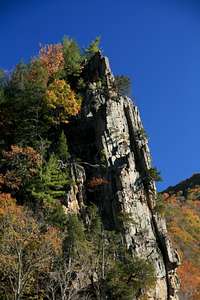
Not far from 220, Eagle Rock rises dramatically from the far shore of the stream, and it is one of the most spectacular sites of the canyon and almost certainly the most spectacular site along Smoke Hole Road (most of the canyon is roadless) Eagle Rock is not a freestanding pinnacle but rather is an exposed edge of larger and higher Cave Mountain. However, its eastern face commands attention and beckons climbers and scramblers who have the means or the desire to cross the often-cold waters of the South Branch.
Eagle Rock is similar to Seneca Rocks in that at the top, it is a narrow, exposed fin, but it is different in that it is limestone, not sandstone quartzite, and it is also not nearly as high or massive. Still, it rises around 300' above the South Branch and it is a worthy short objective for scramblers or a nice all-day objective for trad climbers interested in the handful of routes on its eastern face.
The name honors William Eagle, who enlisted to fight in the Revolutionary War on Christmas Eve in 1776, at the age of fifteen. He served and fought honorably, including at Valley Forge and Yorktown, and died in 1848. His body is buried nearby.
Routes
The nontechnical way up is easy. Cross the river by boat or by foot (in late summer, crossing will usually be easier by foot than by boat due to low water levels, but during times of runoff or flood, crossing by foot could be deadly). Head to the left of the rocky face and find steep but easy terrain leading up. Near the very top, some easy Class 3 moves get you atop the fin and to the interesting summit marker. The actual highest point is a bit to the right (south) of the marker.
Some technical routes I have found through a little research:
* Karma Cracks-- 5.9
* William's Way-- 5.8
* The Standard Route-- 5.8
* Stonewall Jackson-- 5.7
* Begoon-Hensley-- 5.11a
These routes range from 1-3 pitches and 65-300'. See the rockclimbing.com page for more details.
Getting There
From U.S. 220 16.5 miles south of Petersburg, take Smoke Hole Road for 2.3 miles to Eagle Rock. If you access Smoke Hole Road from 28, it is a 15.5-mile drive to Eagle Rock.
Red Tape
The rc.com page says that the land surrounding Eagle Rock on all sides is privately owned. The USGS quad showing Eagle Rock does not indicate this and leaves one with the impression that it is all public land. Keep in mind that some USGS maps have not been updated for several years. Also, although there is a privately owned campground (Eagle Rock Campground) off a spur road on the road side of the river, there are no other signs around Eagle Rock marking private property.Nevertheless, legally, it is usually up to you to know the property boundaries; in some states, you can still be charged for trespassing even if the land is not posted. The rc.com page-- and I can't seem to find when it was last updated-- says you should pay the $8 camping fee and call 540-246-4802 or email wvmgray@gmail.com for more information. I ought to point out, though, that 504 is a Virginia area code and that the area code for West Virgina is 304, so I don't know if that's a typo or bad beta or if the owner lives in another state.
However, I encourage anyone interested in summiting Eagle Rock to practice due diligence and look into the property issues. As author of this page, I do not encourage or condone knowingly trespassing. I do not want to see yet another good crag closed to the public.
When I climbed Eagle Rock, I parked at a pullout along Smoke Hole Road and did not set foot on what was obviously the landowners' property. If I did inadvertently trespass, and if the owners see this page, I do offer an apology and hope that what I have added here will be taken as a sign of good faith from me and from other climbers.