
-
 12016 Hits
-
 84.27% Score
-
 18 Votes
|
|
Mountain/Rock |
|---|---|
|
|
40.21230°N / 105.6644°W |
|
|
Boulder |
|
|
Hiking, Trad Climbing, Scrambling |
|
|
Spring, Summer, Fall |
|
|
12220 ft / 3725 m |
|
|
Overview
 Eagles Beak rises above the basin
Rustic and remote, Eagles Beak is a treat reserved only for the determined peakhunter, but the rewards are many. Eagles Beak is set back high and wild just east of the Continental Divide in Rocky Mountain National Park, in a basin blessedly free of established/official trails. A long approach topped by a short but stiff scramble separates the climber from wide-open vistas across the blocky summit rocks. Much of the Wild Basin area is visible from the top of this craggy little perch. Nearby to the south, the visitor gets close-in views of resplendent Frigid Lake and Moomaw Glacier, while Longs Peak and Mount Meeker dominate the horizon to the northeast.
This peak presents a strong impression of quiet isolation. If you are up for a moderately grueling approach, are comfortable with sustained travel off maintained trails and love a good scramble, this petite little summit just could become one of your area favorites.
Colorado Rank: Eagles Beak is a soft ranked peak, which basically means there is no confirmed 300-ft variance between its summit and the lowest point of the saddle with its next highest neighbor.
Prominence: 280 feet
USGS Quad: Isolation Peak
Planning Map: Trails Illustrated #200 | Rocky Mountain National Park, Colorado, USA
Rank & Prominence: Lists of John
Getting There
 Rising above Eagle Lake
 Across Box Lake
Eastern Approach | Wild Basin Trailhead | 8,500 feet elevation
• Visit the SummitPost page for Wild Basin Trailhead.
• Also refer to this PDF map by the National Park Service.
Western Approach | East Inlet Trailhead | 8,400 feet elevation
From the western entrance to Rocky Mountain National Park at Trailridge Road, drive south on US 34. Turn left toward Grand Lake and then bear left at Tunnel Road (across from the food mart). Continue to the end of Tunnel Road to the East Inlet Trailhead.
 Eastward down the basin Eastward down the basin |  Approaching Eagles Beak Approaching Eagles Beak |  Moomaw Glacier Moomaw Glacier |  Eagles Beak close-up Eagles Beak close-up |
Red Tape
 |  |  |  | 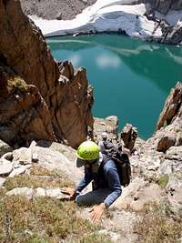 |
 Above Frigid Lake
 Longs and Meeker from Summit
 Hillbilly Deluxe Summit Jar
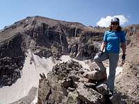 On the summit
As this peak resides within Rocky Mountain National Park, the red tape is thick. The red tape stated here is only a high-level overview. For starters, there are entrance fees (per the National Park Service Website 2012):
Individual Entrance Fees
• Automobile: $20 - Valid for seven consecutive days, including date of purchase.
• Pedestrians, bicycles, motorcycles and mopeds: $10 per person, not to exceed $20 per vehicle. Valid for seven consecutive days including date of purchase. Available at all Rocky Mountain National Park entrance stations.
Additionally:
• Backcountry camping requires a permit, accompanied by a $20.00 administrative fee during peak season.
• Pets are not permitted on trails or in the backcountry.
• Nearly 250,000 acres of the park are federally designated wilderness and wilderness use rules apply.
Camping

Reminder: All backcountry camping within the National Park requires a permit.
Wild Basin Approach
• Backcountry: There are numerous backcountry campsites along the Wild Basin Trail from the east.
• Frontcountry: The nearest frontcountry campground to the Wild Basin trailhead is the Olive Ridge campground. Operated by the U.S. Forest Service, this campground has 56 sites. Amenities include tables, fire grates, water, vault toilets, and trash service. Sites are $17-$20 per night and the campground is typically open from late May through late September.
East Portal Approach
• Backcountry: There are numerous backcountry campsites along the East Inlet Trail from the west.
• Frontcountry: The nearest campground to the East Inlet trailhead is the Green Ridge Campground on the shores of the Shadow Mountain Reservoir. Operated by the U.S. Forest Service, this campground has 78 sites. Amenities include flush and vault toilets, drinking water, and fire rings. Sites are $17-$34 per night.
 Beginning the descent Beginning the descent |  Too friendly Too friendly |
Weather & Seasons
 Bear tracks near Eagle Lake
 Click for weather forecast | As with most any mountain, you are welcome to attempt this peak any time of the year, conditions and will permitting. The long approach, however, made longer by seasonal road closures, makes Eagles Beak a good candidate to attempt in snow-free times. For a detailed forecast pertinent to the RMNP highcountry, visit this NOAA page (“South and East Jackson/Larimer/North and Northeast Grand/Northwest Boulder Counties Above 9000 Feet, CO.”) |  Click for weather forecast |
 |  |  |  |