
|
|
Mountain/Rock |
|---|---|
|
|
40.47220°N / 105.6913°W |
|
|
12949 ft / 3947 m |
|
|
Overview
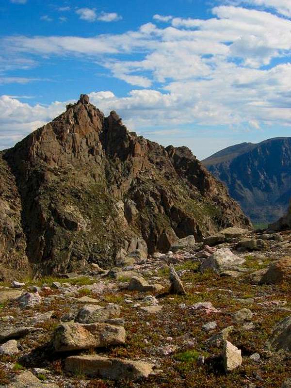
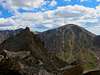
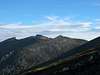
East Desolation Peak as seen from the ridge leading to West Desolation Peak.
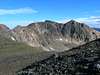
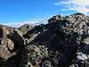
Desolation Peaks are located on the Western fringe of the Mummy Range in the borders of Rocky Mountain National Park. This mountain technically has twin summits -- West Desolation (12,918 ft), and the true summit, East Desolation (12,949 ft). This mountain is not visited very often at all. In fact, it is rumored that the summit register dated back to 1988 (the jar was shattered and the register was no longer there). The approach is very simple, and most often taken, from the Chapin Pass Trailhead. It is nothing more than a Tundra walk, with some nice cirque skirting and small rises (pt. 12,718), until you reach the base of West Desolation Peak. From here it changes drastically to a talus ridden trek, amongst rugged cliffs and large, loose boulders. The ridge from West Desolation to East Desolation is nothing but rotten, loose, unstable rock....a complete mess. Once you reach the low point in the ridge, it is a simple class 4 scramble to the summit.
You can also reach this mountain from the Corral Creek Trailhead near Long Draw Reservoir.
This is a wonderful mountain in one of the most beautiful areas of the National Park (aren't they all!!). It is a peak that had always stirred my curiosity. It looks so remote and rugged from Trail Ridge Road and other mountain summits in the Park. It proved to be all that and more! It was a lot of fun, and tested my route finding skills in a way that no other mountain has. It also gives unique views toward other Mummy summits.
Round Trip: 11 miles
Elevation Gain: 2,309 feet
At around mile marker 6, you will come to the Chapin Pass Trailhead (clearly marked). Follow the signs to Ypsilon Mountain. Keep going, about another 1.5 miles, past Ypsilon until you get to the base of West Desolation.
Maps
Call the Backcountry Office, 970-586-1242, for details on camping.
Fees for admission.
Basic Rules/Regulations
Call 970-586-1242 for further details.
This is a long, strenuous day hike, so please use your basic knowledge of backpacking/mountaineering. Bring plenty of water, food, and clothing etc......
Note that you will be above treeline for 99% of this hike. It only takes 20 minutes to reach treeline from the trailhead, so you will be at the mercy of the weather for the entire day. PAY ATTENTION!!
It doesn't take too long to drop to treeline if necessary, but don't hesitate to do so. I had to hunker down for an hour and a half in the trees directly below Desolation during one hell of a storm. the walk back to the trailhead was nice along the edge of the trees. Got to see a lot of wildlife.
You can also reach this mountain from the Corral Creek Trailhead near Long Draw Reservoir.
This is a wonderful mountain in one of the most beautiful areas of the National Park (aren't they all!!). It is a peak that had always stirred my curiosity. It looks so remote and rugged from Trail Ridge Road and other mountain summits in the Park. It proved to be all that and more! It was a lot of fun, and tested my route finding skills in a way that no other mountain has. It also gives unique views toward other Mummy summits.
Round Trip: 11 miles
Elevation Gain: 2,309 feet
 |  |  |  |  |
Getting There
To get to the Chapin Pass Trailhead, you can enter RMNP from the Fall River Entrance, just North of Estes Park on Hwy 34. On the Western end of Horseshoe Park, take a right towards Old Fall River Rd. This is a one way dirt road that ultimately connects with Trail Ridge Road at the Alpine Visitor Center.At around mile marker 6, you will come to the Chapin Pass Trailhead (clearly marked). Follow the signs to Ypsilon Mountain. Keep going, about another 1.5 miles, past Ypsilon until you get to the base of West Desolation.
Maps
 |  |  |  |  |
Red Tape
The only permit required is a pass to get into the National Park. You can buy a week pass for $15, or an annual pass for $30.Call the Backcountry Office, 970-586-1242, for details on camping.
Fees for admission.
Basic Rules/Regulations
 |
When To Climb
The Summer (June through September) months are when this mountain is most typically climbed. In the Winter months, you will most defiantely need an axe and crampons, and you will only be able to approach this mountain from the Corral Creek Trailhead. Once the snow begins, Old Fall River Road closes for the Winter.Camping
To be honest, I do not think there is any camping in and around the Chapin Pass Trail System. You can camp near Lawn Lake, but this would make an interesting approach to the Desolation Peaks (over Fairchild and up the Northeast ridge of Ypsilon).Call 970-586-1242 for further details.
Mountain Conditions
To get the most accurate conditions on this mountain, it would be best to call Rocky Mountain National Park directly. 970-586-1206.Miscellaneous Info
Basically, the only things you will need to check on before attempting to summit Desolation Peak, would be the weather for the day.This is a long, strenuous day hike, so please use your basic knowledge of backpacking/mountaineering. Bring plenty of water, food, and clothing etc......
Note that you will be above treeline for 99% of this hike. It only takes 20 minutes to reach treeline from the trailhead, so you will be at the mercy of the weather for the entire day. PAY ATTENTION!!
It doesn't take too long to drop to treeline if necessary, but don't hesitate to do so. I had to hunker down for an hour and a half in the trees directly below Desolation during one hell of a storm. the walk back to the trailhead was nice along the edge of the trees. Got to see a lot of wildlife.
External Links
- Desolation Trip Report
A report of report, and pictures, of my hike to desolation peak.
Magicicada - Aug 16, 2005 11:24 am - Hasn't voted
Untitled CommentYou can descend from the saddle between the two peaks to the west fork of Hague Creek. This is a bit tricky at first; slow going if you're careful. You can follow the drainage down past a series of unnamed, but extremely scenic lakes. You will eventually go below treeline, at which time the going will get extremely rough; when you get to the fork in Hague Creek, you can follow it up, and follow the drainage to The Saddle. Note the stunning cliffs on the back of Hagues Peak.
This is an arduous, but unbelievably scenic route through one of the wilder areas of the park. Just remember to watch the weather and budget plenty of time-- your exit over the Saddle is well above treeline.
Other possibilities from the Desolations include continuing on to Flatiron Mountain, or returning by following treeline above Chapin Creek. If you return this way, you'll want to stay at or just above treeline; the further down you go, the rougher the going gets.
Sarah Simon - Jan 28, 2008 3:19 pm - Voted 10/10
Very minor suggestionSmudge, Hey there. Reading through this site, I happened upon a very minor gramatical/spelling issue I wanted to bring to your attention as a courtesy. This is a wonderful mountain in one of the most beautiful area of the National Park (aren't they all!!). I think you meant to make the word "area" plural: "areas". Happy hiking! Sarah
smudge - Jan 28, 2008 6:29 pm - Hasn't voted
Re: Very minor suggestionThanks! Fixed it!