
|
|
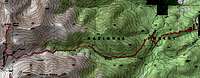
Route |
|---|---|
|
|
38.67230°N / 106.1616°W |
|
|
Hiking |
|
|
Summer, Fall |
|
|
Most of a day |
|
|
Overview
 A good hike
This is not the standard hiking route on Mount Antero, but maybe it should be. A nice forested trail, much less traffic, less noise compared to Antero's west side, and you can still climb the mountain in a single day. This is simply the best hiking route.
The Little Browns Creek trail is easy to get to and easy to climb. It starts at the well developed Browns Creek Trailhead, and follows trails most of the way to the summit. The route is quite beautiful as it ascends through an unspoiled forest. It also offers a good opportunity to climb neighboring Mount White, which shares a lot in common with Antero.
Fourteen miles round trip. 5350' elevation gain.
Getting There
 Mount Antero from the east
Use the Browns Creek Trailhead described on the main page.
County Roads 270 and 272 are smooth dirt roads, and there are enough signs that you won't lose your way or lose too much time getting to the trailhead. There are well maintained restrooms at the trailhead, and lots of parking. Trailhead elevation is about 8900'.
Approach
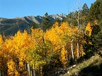 View from the trail
The first thing you must do is ignore the dotted red lines on the large brown sign just beyond the trailhead. The lines are misleading; perhaps the trails have been moved since the sign was made.
Follow the main trail 1 mile west, to its intersection with the Colorado Trail running north and south. Turn right (almost a U turn at that point) and follow the Colorado Trail 0.3 miles north to the Little Browns Creek Trail, 1430. Both trail intersections are signed, although one sign was lying on the ground at the time of my last visit.
Go west on 1430. It will be another mile or so before the trail rejoins the creek. Follow the trail several miles up the north side of Little Browns Creek. You may lose the trail in places, but it is there. It never strays too far from the creek bottom. As usual, the trail is easier to follow on the return trip down. Stay north of the creek and you will be fine. Unfortunately, the creek goes underground much of the way, so you can't always see or hear the water.
As you reach 11,000' and continue west on up to 12,600' Mount White will pass by in review on your left.
Route Description
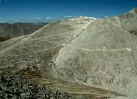 Join the south slopes route
At 12,600', near the end of any discernable waterway, pick up a small trail that angles northwest up to a prospecting dig. There, at 13,050', you will join a spur road, which leads to the the main road, which zig zags up one of Antero's upper south slopes. Follow this road to its end, at 13,700'. Leave the road behind and follow a good trail another half mile along Antero's south ridge to the summit.