
|
|
Route |
|---|---|
|
|
47.66784°N / 121.47306°W |
|
|
Hiking, Mountaineering |
|
|
Spring, Summer, Fall, Winter |
|
|
A long day |
|
|
Overview
This Route page was created with the permission and approval of Paul Klenke, the original creator of the main page for Lennox Mountain.The East Approach for Lennox Mountain is considered the easiest and most recommended (albeit perhaps the longest) standard approach during Winter and Spring seasons, and perhaps the second-most recommended approach during Summer season. The approach is fairly straightforward, and is not considered technical during most times of the year.
The East Approach described here is an updated route version of the “Eastern Route” and “Southeast Route” each described in Fred Beckey’s book Cascade Alpine Guide: Volume 1. Beckey’s “Eastern Route” and “Southeast Route” for Lennox Mountain are similar approaches, with the difference being where to head up to the summit ridge from a large open cirque. The East Approach described here shows both route options, with one route as the primary/recommended option and another route variation as an alternative.
Driving Directions
FROM SKYKOMISH, WA:1) Drive west along Highway 2 for 3.0 miles.
2) Immediately after passing through a tunnel, turn left onto NE Old Cascade Highway (heading towards Money Creek Campground).
3) After 1.0 miles, turn right onto Miller River Road NE (which is generally unpaved).
4) After 3.5 miles further, the road splits. The leftside/straight road becomes Forest Service Road 6412. The rightside road, which is gated at its entrance, is Forest Service Road 6410, commonly known as West Fork Miller River Road.
5) Park near the gate for West Fork Miller River Road. Any street legal vehicle can reach this location. The hiking route begins at ~1300’ elevation.
During Winter and Spring months, the U.S. Forest Service usually snowplows Miller River Road, at least one time and more commonly multiple times, until its intersection with West Fork Miller River Road. The end of the snowplowed road section allows enough room for several vehicles to park there. The road is not plowed on regular intervals, and might only be plowed in mid-Spring (i.e. by early April) after the worst lowland Winter storms have typically ended for the season. It is also possible that Miller River Road will not be plowed at all in the future beyond the first mile, due to future budget cuts.
 End Of Snowplowed Area For Miller River Road
Route Description
 General Route Map For East Approach
1) Hike south along the West Fork Miller River Road. The road is a dirt road in most sections, but a rocky road in other sections.
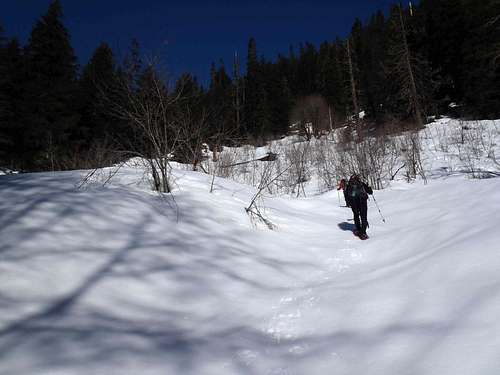 Snowshoeing Along West Fork Miller River Road
2) After nearly 2.5 miles, only a short walking distance prior to reaching Coney Creek, look for an old mining road-trail that veers right and uphill. During periods of snowpack, it is also possible to join the old mining road-trail at a higher elevation by snowshoeing/hiking up an open sloped area for nearly 200’ elevation before angling uphill to the left and entering a forest. Once in the forest, continue angling uphill until the old mining road-trail is encountered.
SIDE-NOTE: If Coney Creek is reached, then backtrack a short distance until finding the old mining road-trail, or angle uphill in the forest until the old mining road-trail is encountered.
3) Follow the old mining road-trail for nearly 1.7 miles until reaching a large cirque (approximately 2750’ elevation).
SIDE-NOTE: Historically, the cirque was home to several mines, at least one of which is still present.
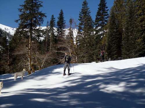 Snowshoeing Up Old Mining Road-Trail To Large Cirque...
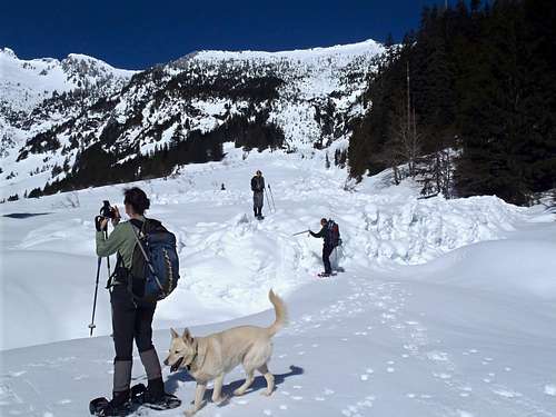 Entrance To Large Cirque ("Coney Basin")
4) Near the entrance to the large cirque, turn right (northwest) and head up a very steep forested ridge. The steep forested ridge has nearly 2400’ of elevation gain in only 1.3 miles. Continue northwest up the ridge until approximately 5100’ elevation. Coney Lake will be around the corner, to the left (west).
ALTERNATIVE ROUTE OPTION: From the entrance to the large cirque, traverse the cirque on its right (north) side for a short distance until reaching a streambed that connects Coney Lake (above) to Coney Creek (below). Follow the streambed gully up to the outlet of Coney Lake (5161’ elevation).
SIDE-NOTE: The large cirque is very prone to sudden avalanches during Winter and Spring seasons. Do not attempt the alternative route option, as well as do not attempt to enter or cross the cirque, during periods of considerable avalanche danger or worse.
 Ascending Steep Forested Ridge...
5) Once on the ridgeline southeast of Lennox Mountain, head west-northwest along the ridgetop for 0.5 miles until reaching the true summit (5894’ elevation). Much of the ridgetop between the false summit and true summit is very gentle-sloped, which can help tired legs for the final ascent.
SIDE-NOTE: For distance/reference purposes, the false summit is passed within the first 0.2 miles from the Coney Lake outlet, then a brief forested section of ridgetop is passed 0.2 miles from the false summit, and then the true summit is reached 0.1 miles from the forested ridgetop section.
 Looking WNW At Final Ridgetop Approach...
 False Summit As Seen From West...
 Following Ridgetop From False Summit To True Summit...
 Ascending True Summit...
ALTERNATIVE ROUTE OPTION: From the outlet of Coney Lake, traverse around the lake and ascend to a saddle on its north side. Then follow the ridgetop westward to the summit. This route variation is slightly longer than the recommended route described above, and should only be attempted if current conditions allow.
6) Descend the same route.
ROUNDTRIP STATISTICS: 12 Miles, with approximately 4600’ vertical gain and possibly 5000’+ cumulative gain.
Expect a long day for this route:
11-13 hours roundtrip with snow, 8-10 hours roundtrip without snow.
Essential Gear
ALL SEASONS: 10 Essentials, Hiking Poles, GPS very helpfulSNOWPACK SEASONS: Ice axe, warm clothes, snowshoes for deep snowpack, spikes/crampons for light snowpack or consolidated snow.