
|
|
Route |
|---|---|
|
|
39.35350°N / 119.89583°W |
|
|
Hiking, Scrambling |
|
|
Spring, Summer, Fall |
|
|
Half a day |
|
|
Class 4 |
|
|
Easy to Sporty (sketchy) |
|
|
II |
|
|
Overview
You may be wondering, how exactly could any route on Chocolate Peak be considered an arete? Well truth be told its not, although the climbing is quite "sporty" (euphemism). I just wanted something to distinguish this hairball bushwack/scramble from all the other eastern ridges that lead towards the summit of this large hill. Regardless, its a fun (and occasionally painful) adventure that breaks up the monotony of the normal Northeast Ridge Trail.Before you read further and start to think this route is a good idea, let me give you a little background about the pioneer of this route, myself. I like to hike shirtless, have an addiction to copious amounts of sunflower seeds, and occasionally wear trendy sunglasses (just in case others might judge my wilderness style). More than anything I have a crazy inability to remain on trail. Those normal feelings, lets call them lemur senses, have been completely erased from my instincts, instead being replaced with the desire to always climb the most difficult and heinous route possible. This is one such route.
Who thought that there could be fun and exciting scrambling on a seemingly dull and mountain such as this? Although not committing, the East Arete is pretty much the most difficult and interesting route on the whole mountain. Make no mistake about it, this can be an enjoyable relief from trail monotony. Or it can be a hellacious and treacherous high mountain jungle style excursion. Its up to you. If attempting this route, go into it with a passion for the weird and mind as open as the beers you'll enjoy afterwards.
 The Route
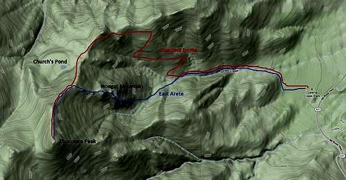
Getting There
From Reno, take 395 South to the Galena/Mt Rose Highway Exit (HWY 431 I guess). Drive West about six miles (towards the mountains dude) and then turn right into the Galena Creek Park. Park your car at either of the Jones Creek Trailheads. If you want to save 0.1 of a mile on the approach (wow, that much?!) you'll use the upper/South parking lot according to forest service signs.Route Description
Start by taking one of the various trails to the Jones Creek Trail. There's a lot of forest service signage at the trail heads, so if you can't figure out how to do this then you probably won't do very well on this route. If this is the case, give up now and do something else. Your best options are continuing on to Lake Tahoe (yeah, further into the mountains dude), taking a nap in the parking lot, or maybe attempting the normal route. At least take a friend if trying the last option.Once on the Jones Creek Trail, continue up alongside the creek. Its pleasant and easy walking (for now). You'll soon enter the Mt. Rose Wilderness, which is signed and hard to miss. Watch for a rocky looking ridge to come into view on the left (south). The Jones Creek drainage splits into two around it, and from here you will catch some of the first views of the route. Continue walking another half mile or so from the wilderness boundary, before veering off the trail to the left (south). This is where the adventure begins. If you reach the first switchback, you've gone too far. Backtrack a little ways and leave the trail to the south.
Immediately after leaving the trail, bushwacking begins. Find some sort of path across a small drainage (may or may not have water) and into a large meadow to the south. From this meadow you'll have a good view of the route to come. If you like what you see, keep going. The route will be the only ridge with cliffs and rock outcrops that is in sight, and looms directly above this meadow.
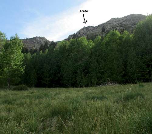
From here bushwack out of the meadow and up the hill towards your route. There's really not a best way, and all routes up this slope will lead to the top. You can chose to anything from a hike up to scary technical climbing. I found the most fun to be had directly on the ridge, so I climbed up to the base of where that started. At this point, Reno starts to come into view.
 Bushwack
 Start of Fun
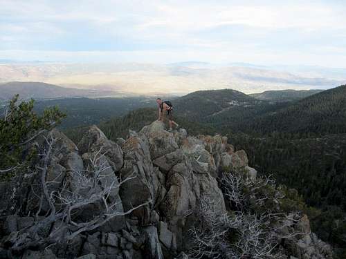
Once at the base of actual rock outcropings, and no longer in the bushwack zone, begin the fun. There are an incredible number of fun routes you can choose from at this point, with no wrong options. Try to avoid more brush. After a couple hundred feet of fun scrambling, an actual ridge will start to develop. This ridge is somewhat committing due to brush and convenience, but can be avoided at any necessary spots. I found staying on the ridge to be mostly class three with some possible class four if you try and stay directly on it. It was actually really fun and quite a surprise for this unassuming peak.
 Many Options
 The "arete" from above
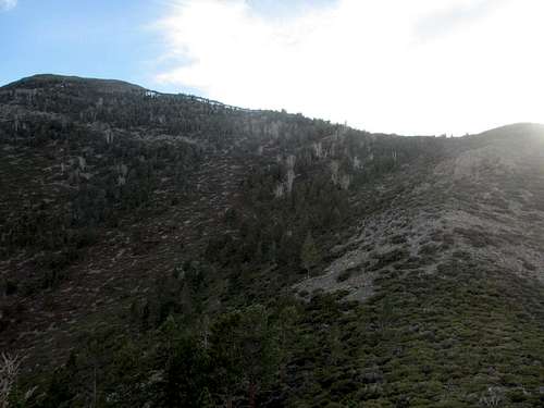
Continue heading up the ridge across several small summits. Eventually you will reach a large sub summit that could almost be considered its own peak. This is Nougat Mountain (newly named so I could brag about climbing one more summit), and is a pleasant spot. From here most of the fun scrambling has been finished, and you can view the rest of the route.
At this point you may be wondering what you've gotten yourself into, or you may be grinning from the views and climbing (obviously not having looked ahead), or you might just be sitting reading a Clif Bar story (or something). Either way, examine the slopes just West of Nougat Mountain carefully. If you haven't worn pants, give up now. This is easily the worst bushwack of the whole route, and will take up significant time. The whole ridge is covered in mountain mahogany, a bristly son of a bitch plant with small stiff branches that resemble razor blades upon contact with the human skin. I managed to find a zig-zagging animal trail that sort of lead me across. At times I jumped over, other times I crawled under. Most of the time I grimaced and swore. In retrospect, I think that the north side of the ridge has less vegetation, although this might just be a rumor. Either way, it can't be worse.
 A summit!
 Nougat Mountain
After surmounting the pit of eternal despair (AKA ridge of Nougat Mountain), there can be a little more scrambling on some volcanic conglomerate. This is a welcome change, and can help take your mind off of the fact that your legs may be gushing blood. After a little more bush navigation (not serious compared to before), you will reach the standard Northeast Ridge route of Chocolate Peak. Follow a loose climbers trail south and to the summit. Congratulations, you survived!
 View of final route
Note: If you can successfully complete this route without death, serious woe, giving up all hope and bivouacking, or mental insanity, then you should be able to find your own way down.