
|
|
Route |
|---|---|
|
|
15.58570°N / 61.4755°W |
|
|
Hiking |
|
|
Spring, Summer, Fall, Winter |
|
|
Half a day |
|
|
Class 1 |
|
|
Overview
This is the standard route up East Cabrit first visits Fort Shirley before climbing a well graded trail to the summit of East Cabrit. Although the well-marked trail follows and uphill gradient, the distance isn't far and reaching the summit is a relatively easy endeavor.Also described here will be the side trip to the Douglas Bay Battery, Officers’ Quarters and Commandant’s Quarters, which is a highly recommended detour.
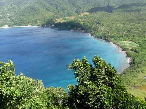 Looking down on Douglas Bay from the slopes of East Cabrit.
Getting There
The first destination is the town of Portsmouth, which is the second largest town in Dominica. Portsmouth can be reached by bus from the Melville Hall Airport on the NE part of Dominica and the capitol city of Roseau on the west coast. Buses to Portsmouth from Roseau leave from the bridge on the north side of Roseau.From Portsmouth, you can walk or take a bus (which is pretty inexpensive) or taxi north to the area of the Purple Turtle Beach or possibly even to the entrance of Cabrits National Park.
If driving or walking, head north from Portsmouth through Lagoon along the coastal road between the beach and Cabrits Swamp. Just beyond the site for the International Maritime Training and Development Institute, keep straight (instead of right) and the road leads directly to Cabrits National Park. It’s a fairly long walk from the south end of Portsmouth (but certainly doable), but only 20 minutes from Lagoon.
 A beach near the trailhead and Portsmouth.
Route Description
From the visitor center (where you must show or buy your site pass), follow the trail through the stone archway and follow the wide trail up to the fortress of Fort Shirley. Take time to poke around and explore Fort Shirley before continuing up the hill. There are signboards explaining some of the history of the area.A sign indicated the West Cabrit Trail to the left and Commandant’s Quarters, East Cabrits Trail and the Douglas Bay Battery to the right.
Douglas Bay Detour
Before (or after) continuing on to the summit of East Cabrit, make sure to take the detour to the Douglas Bay Battery and the ruins of the Officer’s Quarters. From just below Fort Shirley in a clearing, take the sign posted trail to the Douglas Bay Battery.
After a short distance, you will reach a junction with the trail to the West Cabrit and Commandant’s Quarters ruins to the right. Continue straight (north) along the trail until you drop down to the impressive ruins off the Officer’s Quarters (located just left of the trail). The ruins are impressive and eerie since they are overgrown with vines and trees. Three old cannons lie scattered about.
From the ruins you can locate a trail to the west along some steep steps. If you climb to the top of the steps, you will reach a wide trail. If you head right you will reach a fine overlook and ruined wall at the end of the path.
Reverse your route to the Officers’ Quarters and continue reversing your route to a junction with the trail the left (east) and to the Commandant’s Quarters (ignore another trail heading uphill to the north). The route is somewhat confusing here since there was a “Danger” sign with a skull and crossbones. This is the correct trail, but the sign is apparently just warning about some unstable walls of the Commandant’s Quarters (keep away from that wall). The trail to the summit of East Cabrit is on the north side of the Commandant’s Quarters ruins. As of January 2 2012, there was no sign marking the trail.
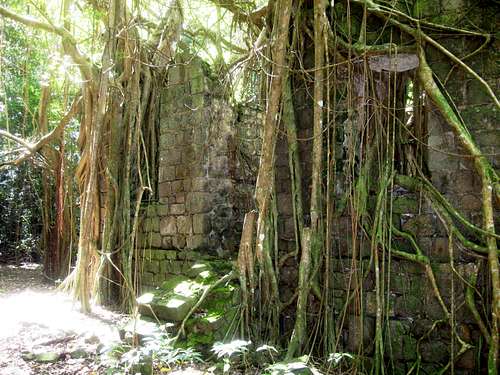 Part of the old ruins at the Douglas Bay Battery, which are located on the slopes of the Cabrits. This is the old officers quarters from the 1700's.
East Cabrit Trail
If you are climbing the East Cabrit before heading for Douglas Bay, located the trail just below Fort Shirley and in a clearing. Follow the trail north and turn right at the trail marked for the Commandant’s Quarters (see above) . Once at the ruins, a wide trail continued north towards Douglas Bay (see above), but located the narrower trail heading up the slopes just north of the ruins. There was no sign here as of January 2 2012, but the trail is in good condition.
Follow the trail up the hill and some long switchbacks. There are some fine views, especially to the north and you can even see the island of Guadeloupe in the distance. After about 30-45 minutes (from Fort Shirley) you will reach a wall which is the ruins of the East Cabrit guardhouse, ordnance store and powder magazine. Follow the wall and climb some stone steps to the ruins of the battery. Continue along the ridge crest to the northeast to the overlook of Douglas Bay at an old ruined battery. The views are fantastic from this location.
After enjoying the fine views, reverse your route to Fort Shirley. If you haven’t already, consider climbing the West Cabrit as well.
Climbing both Cabrits and visiting the Douglas Bay Battery can be done in half of a day.