Overview
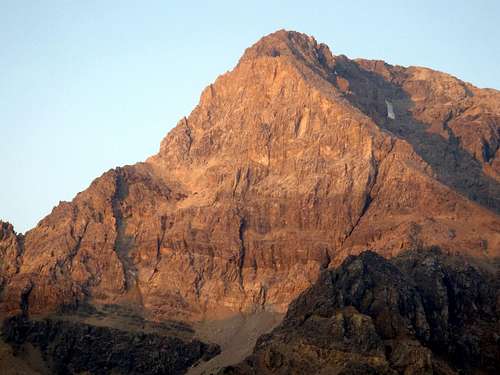
![East Face Mt Idaho]() The East Face of Mt Idaho Sept 21, 2012
The East Face of Mt Idaho Sept 21, 2012![East Face Direct Mt Idaho]() Cory, ecstatic at the top of the last pitch.
Cory, ecstatic at the top of the last pitch.
In Idaho’s tallest range there exists a route that will push you outside your comfort zone. Starting at 10,000 feet, this climb is thedefinition of solitude on alpine rock. Mt Idaho’s East Face Direct was first climbed by Cory Harelson and Kevin Hansen on Sept 22nd, 2012. Even though this climb may never become a classic, it is truly a prize for any experienced alpine climber in Idaho trying to prove their worth. This line was originally spotted one month earlier during the first ascent of the
Mountaineer's Route on the same face. Because the rock is surprisingly sound, the protection is abundant, and the views are second to none this route gets five stars and is highly recommended.
Geology
Idaho’s Lost River Range is an actively uplifting fault-block at the northern end of the Basin and Range province. Extensional faulting has lifted the range relative to the down-dropped Big Lost River basin on its west side, producing steep ridges and slopes essentially devoid of foothills. Interior and eastern regions of the range are deeply incised by the Pahsimeroi and Little Lost Rivers. Most of the range, particularly in the central and southern regions, consists of thick layers of Paleozoic limestone and dolomite. Multiple episodes of tectonic deformation have resulted in dramatic open to isoclinal folding at a scale of meters to kilometers. Glaciation has carved numerous cirques throughout the range and alpine lake basins are scattered in the central and eastern portions. These combined activities have created an impressive assortment of large, high angled faces with western, northern, and eastern aspects.
Getting There
![Pahsimeroi River Access Map]() Access Map
Access Map![The Pahsimeroi Valley]() Pahsimeroi Valley
Pahsimeroi Valley![Pahsimeroi River]() East/West Fork Junction
East/West Fork Junction![Pahsimeroi River Approach]() Warning Sign
Warning Sign
From Mackay, Idaho take Highway 93 north for approximately 22 miles (2 miles north of the Mt Borah access road) and turn right on the Doublespring Pass road (Forest Service Road 116). Follow the "improved" dirt road for about 7 miles to the summit of Doublespring Pass and then drive another 3 miles to the junction of Forest Service Road 117 on the right. The road takes off up a hard switchback and here the real adventure begins. There used to be a sign that indicated Horse Heaven Pass but I don't know if it's still there. Signs have a way of attracting bullets (just like cow pies and flies) in this country. Follow this road for about 1.25 miles to the first junction and take the right hand fork to Horse Heaven Pass. From Horse Heaven Pass drive another 2 miles to the next junction where again you turn right. Continue on Forest Service Road 116 for another 7 miles to the junction of the East Fork and West Fork of the Pahsimeroi River. Follow the West Fork junction to where the road ends at the unimproved campsite. The Forest Service trail to Merriam Lake starts where the road ends. From the Merriam Lake trailhead follow the stream for a few hundred feet until you spot a wooden sign that points to the right, away from the creek. Stay on the well used trail up several steep hills to gain enough elevation to reach the lake. You may camp on the east side of the lake or continue around the north shore where you'll find more biv sites higher up. From here continue west, up the scree slope and moraine towards the bottom of the face. (Tank up! This is the last water you’ll find until you get back). Eventually the slopes lead to the base of the wall. You may find climbing the class 3 black rock band easier than the scree hiking as the FA team did.
NOTE: Come well prepared and plan for self-sufficient travel in this remote country. Cell phones and satellite phones may not be reliable in some locations and there can be long distances between good water sources in the late season. 2-ply sidewalls and tubeless tires might not survive this trip so make sure your spare is full-sized, inflated and you know where the jack is and how to use it. Don't forget your lug wrench. If you break down in this country or get snowed in you may have to walk out. Search and rescue in this range can be difficult, expensive and a real burden on the local law enforcement and Forest Service staffs who are the first to be called for emergencies in this area.
Route Description
![East Face Direct Route Photo]() Mt Idaho's East Face Direct route photo Mt Idaho's East Face Direct route photo |
![East Face Feature]() The East Face of Mt Idaho "features" pic The East Face of Mt Idaho "features" pic |
![East Face Mt Idaho Routes]() The East Face of Mt Idaho showing the two new routes The East Face of Mt Idaho showing the two new routes |
![East Face of Mt Idaho]() Cory starting P1 Cory starting P1 |
P1 of Idaho’s East Face Direct starts in a crack system just right of the obvious right facing dihedral “Grand Central Chimney” in the middle of the wall. The rock is steep and protection can be found in and around the crack. The first 30 meters is 90 degrees of 5.9+ spicy climbing. The next 30-40 meters is less steep 5.8 climbing. The top half of the pitch is composed of banded iron dolomite which is rarely loose and every move is pulling on back-cut, upward sloping jugs and ledges.
P2 is a full rope stretching pitch of 70 degree 5.7 climbing. Gear goes in easily and the pitch ends on a large ledge below and to the right of the “White Triangle”.
P3 30m of vertical to overhanging 5.10a climbing will test your vocabulary. This pitch follows a steep water streak to the right of the White Triangle (Not the black water streak on the side of the white triangle but the next water streak to the right). The protection is sparse but manageable, the holds are there but the sequence is tricky to unlock. The rest of the pitch follows a right angling crack (5.8) up to a small, but solid belay ledge. This pitch is full value.
P4 works back to the left as a (5.7) scramble on 70 degree rock and finishes under the double dihedral. Three pieces of gear were placed by the FA team however there are many places to protect a fall. The quality of the limestone is very high and risk of falling is very low. It is wise to build a belay on the arete’ 100 feet below the two dihedrals. This allows the belayer the ability to watch the leader as they finish the final pitch.
P5 Is a full value 5.10b/c pitch that starts with a 5.6 climb up the arete’ to the bottom of the left facing dihedral (to the North). The bottom of the crack is 15 feet of finger locks with poor feet. Eventually hand jams and good gear lead you to a big (cinder block) stance just below a great roof on the climbers right. The crack moves around the left side of the roof and leads to 5.9 climbing above. Despite the rating, this pitch will make you fist pump at the summit and yell, “I DID IT!” several dozen times. The gear and rock is solid but the moves are gymnastic. A very memorable pitch.
Red Tape
None at all but it's probably a good idea to let someone know exactly where you are going.


 6821 Hits
 88.61% Score
 27 Votes
 The East Face of Mt Idaho Sept 21, 2012
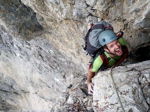 Cory, ecstatic at the top of the last pitch.
 Access Map
 Pahsimeroi Valley
 East/West Fork Junction
 Warning Sign
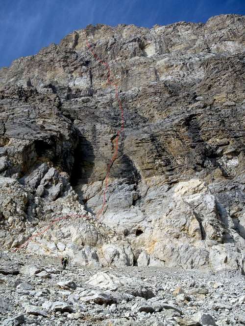 Mt Idaho's East Face Direct route photo
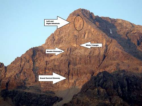 The East Face of Mt Idaho "features" pic
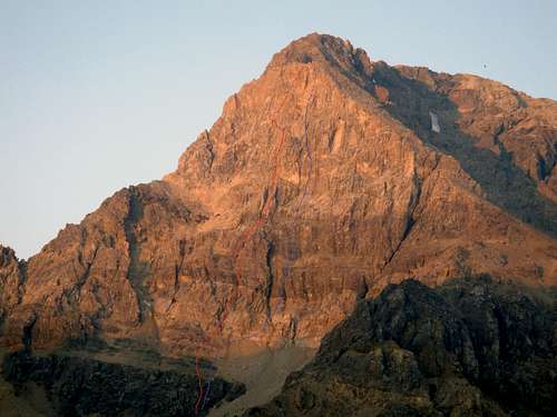 The East Face of Mt Idaho showing the two new routes
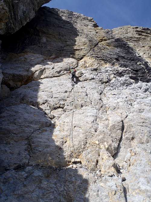 Cory starting P1
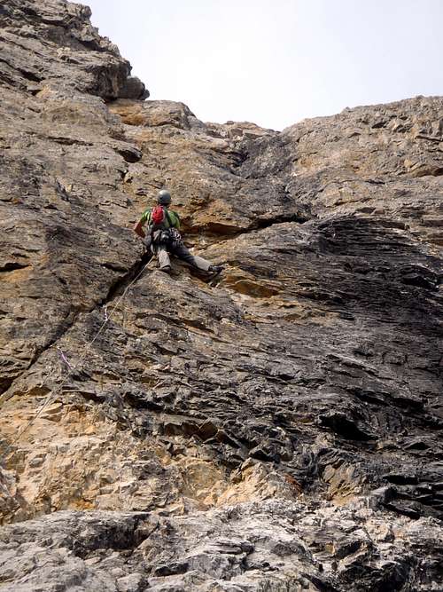 Pitch one
 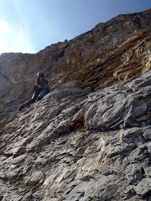 Cory at the overhanging P3
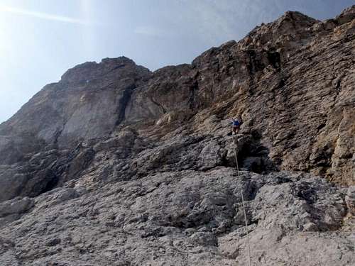 Sept 22, 2012
 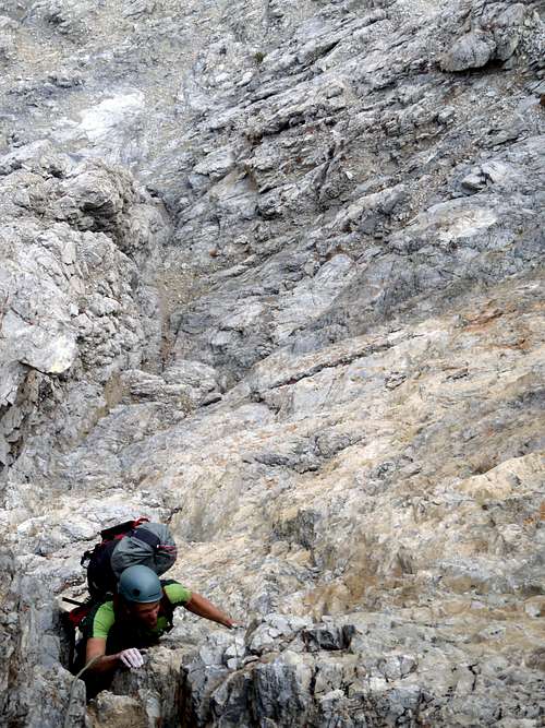 Cory at the top of P5
 Kevin taking a break