|
|
Route |
|---|---|
|
|
37.84476°N / 107.98242°W |
|
|
Mountaineering, Scrambling |
|
|
Spring, Summer, Fall, Winter |
|
|
Most of a day |
|
|
Class 3 |
|
|
Overview
Gladstone Peak is the little brother of the Wilson Group of peaks near Lizard Head Pass. But don't let that fool you; there's nothing little about Gladstone. And with only one standard, viable route to the summit, (North Ridge), Gladstone can be hit/miss in regards to summit success.
The East Face is a sceondary option. This route is climbed so infrequently, I could find only one other party who's done it (documented at any rate). Though considering the other peaks in the area, the other climbing routes and hiking trails that criss-cross the local, I have no doubt that this route has been done before by [countless] others.
The mileage on this alternative route comes in at about 13.4 miles (round trip) with about 4,700' of elevation gain, so expect a long day. The bulk of this is on class-1 trail. There's maybe 30% off-trail hiking and some loose 3rd class scrambling near the top. Compared to the North Ridge, the exposure on this route is not as high. But snce this route is entirely hidden from the west, you won't know what thr weather is doing until you hit the ridge, very near to the summit.
The rock is typical San Juan choss. This particular mountain isn't volcanic but it is loose in typical Wilson fashion. Approach this peak with reverence and caution.
Approach
The easiet way to approach this route is from the Cross Mountain Trailhead. Leave Telluride on Co. 145 driving south towards Lizard Head Pass. This is about 28 miles. Drive an additional two miles southwest down the other side of the pass to the trailhead which, is located on the north side of the road (right). The trailhead is at 10,050' and is accessable year-round.
The approach trail is around 3.5 miles (one-way) to the junction with Lizard Head Trail. From here, the views of Lizard Head Peak (arguably Colorado's hardest 13er) are sobering. This approach trail will yield you around 1,960' elevation gain. It weaves through forest, open meadow and glen. As approach trails go, this one is actually quite nice.
Kepp hiking northwest on the Cross Mountain Trail towards Bilk Basin. At this point, the East Face is in view the entire way. You can leave the trail pretty much at any point from here on out. Simply head due west down the slope/ravine to the bottom. Continue hiking west towards the face up gradually ascending tundra. The grass will eventually give way to rock patches, scree and rock ribs. At around 12,300', the route begins.
Route Description
Even though this is techynically a face scramble, the route is fairly straight-forward and easy to follow. From the bottom, you'll notice a cliff band about 3/4 the way up the face; shoot for this band. Begin scrambling up a choss-covered slope. This is a miserable ascent (when is it not?). There is a series of rock ribs climbers right. I found these to be much more enjoyable and solid. There's even opportunities to get in some 4th class climbing moves along these ribs.
Near the top of these ribs, you'll notice a LARGE boulder, about the size of a house. It's easier to scramble around this obstacle to the right. You could actually just climb this if you wanted some fun, as it looks no harder than 4th class. From the top of this boulder, it is perhaps another 150' to the bottom of the cliffs. This cliff band gets progressively harder the further right you end up. However, having said that, nothing really exceeds difficult 4th class. In fact most of it seems to be about 3+.
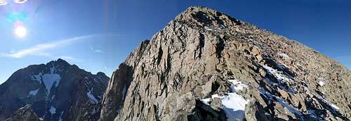
Finish the scramble to the East Ridge. The views across Gladstone's Southeast Face will take your breath away. You'll now be able to see Mt. Wilson and El Diente. Continue to the right on an ascending traverse across the upper face until you reach the Northeast Ridge. The rock will get marginally better. The summit is only another 100'-130' away. Enjoy your prize!
Essential Gear
- Sturdy boots
- Pole(s)
- General Mountain Axe (if snow is present)
- Typical high-altitude clothing, weather dependent
Miscellaneous Notes
Gladstone is located in a sub-range of the San Juan Mountains called the San Miguel, of which peaks like: Black Face, San Bernardo, The Wilsons etc. are part of. The rock here is loose, though not as bad as some of the volcanic areas of the San Juan's. The trails through this area are quite nice and the maps are accurate.
The North Ridge has been the standard route for decades. Probably because of its ease of accessablility from Silver Pick and Navajo Lake. The rock however, is loose & bad. Plus the route is exposed. The only beneft I can see to the North Ridge over the East Face, is one can retreat if necessary if the weather starts to turn bad; You'll have unobstructed views to the west. Otherwise, the East Face in my opinion is slightly easier and safer. If solitude is your thing, you'll also have more of that. Plus as an added benefit, you get to see Lizard Head up close!
Pretty good trip report from 14ers.com. Gladstone Peak-East Face