
|
|
Route |
|---|---|
|
|
37.14100°N / 118.565°W |
|
|
Hike / Scramble |
|
|
Half a day |
|
|
class 2-3 (4 if you want) |
|
|
Approach
From the Bishop Pass trailhead at South Lake, head south on the extremely obvious and well maintained trail toward the pass. Along the way, admire the fantastic scenery, which includes lakes and forests, granite and wildflowers, and…lots of mosquitoes in summer (don’t forget repellent).
After about two miles, you will be in the vicinity of the outlet of Long Lake. In case you do not have a map, you will know you are in the area when you come to a flat meadowy spot with lakes on both sides of you. The lake on your left (east) is just a pond, really, while the lake on your right (west) is actually an arm of Long Lake.
Between the two lakes, leave the trail and head west about 40 feet until you pick up a good use trail heading around the north side of the arm of Long Lake. Follow this trail ¼ mile or so to the outlet of the lake, where you will encounter a creek that eventually drains down to South Lake
Crossing the creek in early season can be tricky as there will be rushing water and lots of obnoxious brush – later season will likely be much easier. In early season, instead of wasting time looking around for a decent crossing (I never found one in July), just take off your shoes and carefully ford the creek (trekking poles are helpful for this).
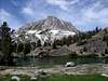
Once across the creek, look to your west/southwest and behold the east face of Hurd Peak above you.
 |
Route Description
It’s hard to mess this up.
Once across the creek at the outlet of Long Lake, head cross-country to the base of Hurd Peak. Any route will do. To stay away from more challenging terrain ahead on the face (unless that’s what you’re looking for), I recommend you aim for the middle-southern portion of the face instead of the northern portion, where there is a prominent buttress and more cliffy terrain.
Near the bottom of the mountain, the going is a tad on the cliffy, ledgy side and class 3-4 climbing (easier climbing can be found if you look hard enough) is needed to get onto the easier terrain above. Once above the cliffy, ledgy terrain, pick a line up.
Although the going is steep, any route will do. There are a series of chutes, which are full of sloggy sand, or you can sticky with the more brushy, bouldery terrain outside of the chutes. Regardless, go up. It’s tedious, but goes quickly.
Near the top of the face, you will notice that you are approaching a headwall-type area – this is actually the summit ridge. The summit is on the south end of the ridge.
Once you get to the “headwall”, you can either a) climb class 3-5 terrain directly up to reach the crest of the ridge and then follow the ridge south to the highpoint, b) traverse over to the south end of the ridge-headwall and look for a loose class 2-3 ramp system that will dump you out right at the summit, or c) aim for a prominent notch near the northern end of the ridge-headwall (this notch will lead you to gentler terrain on the western side of the ridge…from the notch, head south over class 2 terrain until you get to the highpoint). Any of these choices will lead you to the summit. It’s quite easy and the route-finding is not difficult.
Once at the top, enjoy the view.
To descend, retrace your steps.
Essential Gear
In summer and summer-like conditions – basic hiking gear for this easy, half-day outing.
In early season, winter and winter-like conditions – winter climbing gear, including ice axe and crampons, and perhaps snowshoes.