
-
 11177 Hits
-
 79.04% Score
-
 10 Votes
|
|
Route |
|---|---|
|
|
48.57300°N / 113.516°W |
|
|
Scrambling |
|
|
Spring, Summer, Fall |
|
|
Most of a day |
|
|
GMS III(4)LS |
|
|
I |
|
|
Approach
The trail starts at the Cut Bank Campground, and there is a small parking area, usually not filled. If you've stayed in the campground, and reserved the site for another night, more the better—you can simply leave your vehicle there. This trail is very well marked, and quite good all the way to Triple Divide Pass, which is a relatively easy seven-and-a-half mile trek through meadows, forest, for a way keeping alongside the North Fork Cut Bank Creek, and typical GNP mountain stuff—you won't be bored! Elevation gain doesn't really begin until you've covered almost half the distance (during the last three miles or so, the trail works its way around and up the south-facing slope of massive Mount James, which occupies the opposite end of Triple Divide Pass across from Triple Divide Peak), and even then the grade, though steady, is never anything more than moderate—this particular outing is not at all difficult until you reach the mountain! Total elevation gain from campground (which is approximately 5100' elevation) to summit is a relatively modest 2900 feet.Route Description
Vernon's Description and Observations
There are two ways up Triple Divide Peak, and even though I did only the Cliff Route, I'm going to cover the other option as well, the terrain of which is visible in the accompanying pictures, and except when scrambling up to the low point of the saddle between Triple Divide and Razoredge Mountain, presents no problems. Climbing the cliffs, of course, is another matter entirely, but is also much more interesting. I was alone, in perfect conditions, and while at times feeling as though my personal limit for solo exposure was not far off, never felt that I had ventured into the area of pushing myself too close to the edge of safety. And let my add that in my climbing abilities and experience, I'm not a mountain goat—on such terrain, while certainly not a beginner, I'm by no means anything approaching expert. If you are bothered by exposure, and vertical climbing, don't do the cliffs—there are indeed areas which can cause problems—however, the ascent is not without its moments of relief, either, so once on the way, breaks can be taken if desired. This would also be a fun climb with partners—to talk your way up, picking and choosing the way as you go (there is not necessarily one specific route that is "best"). I estimate that time from pass to summit would be about the same for either approach.
The "easy" ascent of Triple Divide Peak is quickly described by this short quote from A Climber's Guide to Glacier National Park: "Hike…to Triple Divide Pass, then examine the routes to the summit of the peak. About four miles [sic] south of the peak, at the lowest part of the saddle between Triple Divide and Razoredge Mountain, a steep little scree slope extends from the gentle meadows up to the saddle. It is a pleasant walk from there to the summit…" Note that the usually reliable Edwards says "four miles"—no doubt a typo simply missed in editing—when the actual distance is four-tenths (.4) of a mile. He suggests going all the way to the pass, then crossing below the cliffs, beneath the east face of Triple Divide Peak, to the saddle—which will of course work, but it may save a bit of energy and elevation gain to leave the trail shortly before actually reaching the pass, so as to cut somewhat more diagonally towards your goal. This is not a particularly important decision, and need not be worried about in advance; do whatever seems logical at the time.
Also briefly, this is what Edwards says regarding ascending the cliffs: From the pass "...walk up the ridge from the trail toward the summit of Triple Divide Peak. The ridge is class 2 through the formation of black igneous rock, then the pitch steepens abruptly. Traverse left (south) for a few yards and into the broad basin. Climb directly upward on class 3 gullies and ledges. A little higher it is best to angle toward the right, because the rock is more solid there, but either way will lead to a distinctly orange ledge that extends entirely across the upper east face. That ledge traverses just beneath the sheer upper cliffs and provides easy access to the south ridge of the mountain." One caution needing pointing out is that these cliffs are, as Edwards describes elsewhere, "unusually rotten," which in Glacier-Park-Speak means BE CAREFUL—this is very crumbling, deceiving, sedimentary rock, and not to be trusted without the constant testing of hand and foot holds!
After arriving at the pass proper, I spent several minutes trying to locate the exact route Edwards describes above, and if the orange ledge still exists, either he and I interpret colors differently, or I was well off his suggested route (in other words, I never found the ledge). At any rate, it's not my feeling there is any one route up these cliffs that is better than the others. There are gullies and ledges aplenty to choose from, and routes seem to be largely intuitive. I do recommend, as he also does, staying "toward the right," because these cliffs are indeed rotten and crumbly (don't forget your helmet!), and I agree that in that direction they are just a bit more trustworthy. While no expert on class, I'm pretty sure some of the ascent was class 4 (see main page for information on the GNP rating system)—probably meaning I was indeed off his specific route—but other than using extreme caution with handholds and foot placement, I encountered nothing I can describe as being not safely doable without protection (well, I did sort of almost wander out onto the sheer north face—see the Trip Report—but you needn't do that; just don't go quite that far right, is all!). Although, and I'll say it again, there is enough unrelieved exposure that if you are bothered by that sort of thing, I recommend going up via the ridge between Razoredge and Triple Divide. Lastly, I did indeed summit, as mentioned above, via an easily traversed ledge, of which there are a couple high on the mountain to choose from, leading across the east face to the south ridge, and then a short, simple, walk to the top.
I do not recommending descending the cliffs by yourself. It seems to be invariably easier going up than down in climbs such as this, and my opinion is having others along to help guide hand and foot placement is the only circumstance (along with good weather) under which I'd retrace the ascent through the cliffs. If alone, walk down the long ridge towards Razoredge Mountain, reach the low point in the saddle, scramble down, then head back to the pass. (And don't do what I've described in my Trip Report!)
 |  |  |  |
Fred Spicker's Description and Observations
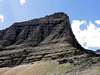
 East Face with snowfield.
 "Orange ledge"
I climbed the route under somewhat different conditions than Vernon and have the following observations regarding the route.
2011 was an exceptional snow year and even on July 23, there was still a snowfield on the East Face. I assume that this forms each year and might be encountered on any early season climbs. It blocks access to the lower part of the “broad basin” described by Edwards. You can climb the face / ridge climber’s right of the snow and traverse above it – nothing more than class 3 – to enter the basin at a higher level.
Then proceed up as described to the “orange ledge”. I think that I identified the orange ledge. It is directly below the somewhat overhanging blackish rock about three fourths of the way up the face and extends virtually all the way across the face. It shows up prominently (but not prominently orange) from the pass - see all the attached photos of the face.
Rather than traverse all the way to the south ridge as suggested by Edwards, I found a very nice shallow class 4 chimney through the cliff band above the ledge which led to class 3 ground above and allowed me to climb almost directly to the summit. I ended up only about 30 feet away.
Snow conditions did not make the “steep little scree slope” an option for descent. It was a steep snow filled couloir with an overhanging cornice at the top. The “gentle meadows” were steep snow fields extending to the tops of cliffs below.
I was able to down climb the route, and was certainly more impressed by the exposure on the way down than on the way up…
Essential Gear
Technical gear not needed in good weather, but bring a helmet!In Tribute
On March 1, 2011, Vernon Garner, Saintgrizzly, left us after losing a bold, inspiring fight against pancreatic cancer. Or maybe he won, for he is at last free of his pain and has "shuffle[d] off this mortal coil."Vernon was an important contributor on SummitPost, but beyond merely making good, informative pages, he actually inspired many who read his work. No one put more work into his or her pages than Vernon did, and many of those pages, especially those related to Glacier National Park, the place he loved above all others, are works of art in both the writing and layout. More than one person has wanted to visit Glacier or go back to Glacier largely due to what he shared about that magnificent place.
Many people on SP counted Vernon among their friends, and many more saw him as one of the best, one of those who exemplified the spirit of this site. He was one of the best of us, he will be missed, and he will not be forgotten.
As a tribute to him, Vernon's pages will remain in his name. Any member who sees a need for an addition or correction should please contact site management via the "Send PM to the Elves" feature.
Rest well and climb on, Vernon.