
-
 4103 Hits
-
 70.83% Score
-
 1 Votes
|
|
Route |
|---|---|
|
|
40.78340°N / 110.6232°W |
|
|
Hike - Scramble |
|
|
One to two days |
|
|
Class 3 |
|
|
Approach
All mileposts are referenced from the trailhead.
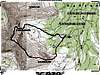
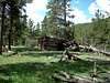
From the parking lot head back down the road to the sign-in board and to the bridge crossing the East Fork stream. Follow the well-beaten (horse) trail south while on the east side of the aforementioned stream for approx. 1.3 miles to the first major stream ford (good log bridge, 6-2004). At approx. 2.9 miles is the second and largest ford. Here the bridge has been washed down stream a ways. Either remove shoes and cross or try and jump to the logjam (6-2004) which is what I did and had no mishap both ways. The previous half-mile contains a large marshy area during the wetter time of the year and an old log cabin Cabin. Continue through a large field and passing another log cabin Cabin while crossing a few smaller drainage’s (streams) to milepost 5.9 to another large stream ford. At this point pass up the stream crossing and follow the West Side of the stream for an enjoyable undulating hike to large cairn and tree blazes that continue west and leaves the stream, at approx. milepost 6.9 (elev. 10,100). Leave stream and follow the blaze marks west, than north (shortly) and than finally south after gaining the ridge, continue southerly to milepost 7.9 (elev. 10,650). This point is shown as the camping spot as shown on the referenced quad maps.
 |  |
Route Description
Trailhead elevation 9250’
4200’ of elevation gain
10.2 miles - one way
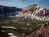
From camp grab an azimuth of 180 degrees and follow through a few marshy areas and up hill to the base of the East ridge line at milepost 9.1 (elev. 11,150). At this point it’s very elementary, pick a route while heading west and up the throat to milepost 9.5 (elev. 12,200). From here the grade flattens to the summit at milepost 10.2 (elev. 13,156)
 |  |  |  |
Essential Gear
During the summer months no technical gear is required.
For Winter Crampons\snowshoes\skis would be useful - and maybe a snowmobile to get you to the trailhead