
-
 2963 Hits
-
 79.04% Score
-
 10 Votes
|
|
Route |
|---|---|
|
|
39.97100°N / 114.6025°W |
|
|
Hiking |
|
|
Spring, Summer, Fall, Winter |
|
|
Half a day |
|
|
Overview
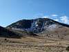
This is the shortest route up Becky Peak. It consists of approximately 1 mile (2 miles round trip) with about 1,070 feet of net elevation gain from the East Northeast.
 |
 |
 |
 |
 |
Getting There
From Ely, NVDrive North on HWY 93 for approx 39.1 miles
From Here, follow the GPS Coordinates in the table below and reset your Odometer.
| WPT | Directions | Latitude | Longitude | Distance to Drive (mi) |
|---|---|---|---|---|
| WPT 1 | Turn Right onto SR-2 [CR-18] | 39°47'42.9"N | 114°43'57.2"W | 10.8 |
| WPT 2 | Turn Right | 39°49'34.7"N | 114°33'41.0"W | 7.5; 10.8 miles from HWY 93 |
WPT 3 | Turn Left (West) into Box Canyon | 39°56'57.2"N | 114°34'02.3"W | 5.6; 18.3 miles from HWY 93 |
| WPT 4 | Park | 39° 58.4030'N | 114° 35.2646'W | 23.9 miles from HWY 93 |
 Driving Directions from Ely, NV.
From Salt Lake City, UT
From Here, follow the GPS Coordinates in the table below and reset your Odometer.
| WPT | Directions | Latitude | Longitude | Distance to Drive (mi) |
|---|---|---|---|---|
| WPT 1 | Turn Left off of Alt HWY 93 | 40° 6.281'N | 114° 114° 33.134'W | 9.0 |
| WPT 2 | Turn Right | 39°59'07.3"N | 114°30'57.1"W | 1.9; 9.0 miles from Alt HWY 93 |
WPT 3 | Turn right at Fork | 39°59'31.4"N | 114°32'53.3"W | 4.5; 10.9 miles from Alt HWY 93 |
| WPT 4 | Park | 39°58'24.2"N | 114°35'15.9"W | 15.4 miles from Alt HWY 93 |
 Driving Directions from Salt Lake.
 Cattle Guard encountered from Salt Lake Route
Route Description
The first half mile consists of a steep hill with almost all the elevation gain on this steep section. Create little switchbacks for yourself to make it easier. The terrain is grassy and with some little rocks, but no scrambling or huge talus.Once you reach the main ridge you will hike by a false summit that is only about 1-2 feet lower than the true summit. Continue hiking along the ridge until you reach the summit.
 3D view of the Route.
 GPS Trace
Essential Gear
Good Hiking boots. There is some desert brush, but it is not too bad.External Links
