
|
|
Route |
|---|---|
|
|
33.05120°N / 116.4792°W |
|
|
Hike |
|
|
Half a day |
|
|
Easy Class 2 |
|
|
Approach
The reach the base of the climb take Highway S2 south from Highway 78 or North from Interstate 8. At mile marker 21.5 turn west onto a dirt road leading toward Granite Mountain. Follow this well worn dirt road for approximately a mile until it dead ends, park here. This turnaround site will be the beginning of the hike up Granite Mountain's East Ridge.
 |  |
Route Description
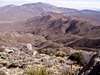
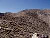
From the turnaround at the end of the dirt road hike down 10-15ft into the wash, then begin hiking directly up the wash leading toward Granite Mountain. This wash usually has a well worn use trail. The first time the wash splits in 2 at approximately .2miles stay in the main wash(left). You'll then scramble over several dry falls(usually), finally reaching a place where the canyon forks three ways. Stick to the righthand branch, and after a couple hundred feet turn to your left up the ridge between the middle and right fork. Follow this ridgeline West toward the saddle at 4600ft. From here the false summit at 5100ft will appear directly in front of you.
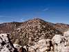
This is the most difficult part of the hike. The ridge between the saddle at 4600ft and the false summit at 5100ft is usually heavily covered in brush, manzanita, and boulders. I found the easiest way up was to stick to climbers left, the right appeard to have more large boulders and many more deadends. From the false summit at 5100ft it is an easy walk on use trails up to the summit at 5633ft. The summit is the high point of a broad ridgeline stretch from East to West, the East end being the highest. Views abound in all directions, from Southern California's highest peak(San Gorgonio to Mexico). See the Topo! for my route of ascent.
 |  |
Essential Gear
No specific gear is needed for this climb. A sturdy pair of boots and pants are recommended to make hacking through brush much more comfortable. As with any desert hike at the very minimum 2L of water should be consumed along the way. The road in is an easy dirt/sand road which I did in my 2wd Acura.
Miscellaneous Info
If you have information about this route that doesn't pertain to any of the other sections, please add it here.