
|
|
Route |
|---|---|
|
|
39.71530°N / 105.91141°W |
|
|
Mountaineering, Scrambling |
|
|
Spring, Summer, Fall, Winter |
|
|
Half a day |
|
|
Class 3 |
|
|
Overview
This is the standard route up the Citadel. It consists of a hike up along the Citadel’s east ridge, a scramble up a steep and loose gully, and then scrambles up to each summit. It is also possible to modify this route and to take on the east summit more directly, bypassing the normal ascent gully. Depending on the year, this climb can be done in snow-free conditions in the mid to late summer and early fall. Route Map
This route would be a rewarding climb for everyone from the seasoned climbers, to hikers who are looking to expand their mountaineering experience by adding some factors of exposure, loose rock, and some simple route finding to a day out amongst the peaks. Depending on the time of year, this route can also provide some good snow experience. There are some snow slopes in the area which could provide reasonable opportunities to practice ice axe skills.
Round trip mileage: 9.3 miles
Elevation gain: 3,020 ft.
Approach
Herman GulchStart from the Herman Gulch Trailhead. (Please refer to the "Getting There" section on the Citadel mountain page. Begin hiking up the trail from the trailhead. The trail heads due east for roughly 200 yards before splitting. Take the left fork (the Herman Gulch Trail). The right fork continues off to the NE and leads to Watrous Gulch. The Herman Gulch trail heads off to the NW. Continue along the trail as it follows the creek to its left. The trail will begin to go in and out of the forest and will cross three avalanche chutes. Eventually the trail begins to contour up across the south-facing slope of the valley as it climbs up onto the shelf which sits below Pettingell Peak. After arriving on the shelf, follow the now much flatter trail as it takes you to Herman Lake. Even before arriving at the lake, the Citadel will loom above you to the WSW. The route which you will need to travel in order to reach The Citadel's east ridge will also be before you.
Follow the trail until it fades on the east side of Herman Lake's outlet stream. Cross the outlet stream and contour along the slope above the stream and the marshy areas downhill and to the left. Try to preserve your elevation as you traverse over the slope aiming for the basin which sits below the Citadel's east side. In this area you will encounter some areas of cliffy rock faces. Either traverse above or below them as your chosen path dictates. You will also encounter some small streams in this area running down from the upper reaches of the slope. After crossing a talus slope, you will find yourself in the basin below the Citadel.
Your next goal is the saddle which sits to the east of the Citadel. Look for a climber's trail which angles up the slope to the saddle. Cross the basin by scouting the driest route. After reaching the climber's trail, follow it up across the scree slope and onto the saddle.
Dry Gulch
The saddle east of the Citadel can also be reached by an approach which travels up Dry Gulch. This approach is shorter, but steeper, than the Herman Gulch approach. Dry Gulch is also much less traveled. After reaching the construction yard described in the "Getting There" section on the main page for the Citadel, continue NW along a trail until it fades. From here bushwack up the drainage, staying on the north side of the creek. Once south of Pt. 12,671, climb up and across the steep slope below the Pt. toward the more gentle basin to the SE of the Citadel, and SW of Pt. 12,671. Once in the basin, continue up toward the saddle to the north.
Route Description
From the saddle, hike up the Citadel's east ridge.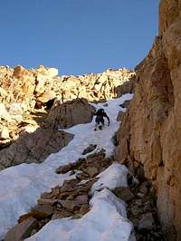 South Gully
In order to reach the east summit, you must first overcome the crux of the scramble, which lies just above the saddle. Look for a corner or dihedral in the rock which provides access up the cliff section that rises above the saddle. (See image here) Climb up this rock corner to reach easier ground which lies just above. Some rate this crux at class 3, others at class 4. It is not particularly difficult, and foot and hand holds are plentiful. The section is also not terribly exposed. Once above the crux, continue scrambling up to the east summit.
To reach the west summit, scramble left (west) from the saddle, up steep rock. The west summit is more jagged and exposed than the east summit. However, the view of the east summit from this rocky perch reveals its own quite breathtaking character. The view from these summits of the mountains in the distance, on every side, is wonderful.