
|
|
Route |
|---|---|
|
|
39.33920°N / 106.0047°W |
|
|
Hike |
|
|
Most of a day |
|
|
Class 1 |
|
|
Approach
The Tarryall Creek Trailhead is located at the intersection of the Gold Dust Trail with Park County road 50. From US-285, turn west on the Boreas Pass Road between Fairplay and Jefferson (signage on the highway here notes the town of Como and also Boreas Pass) and set your odometer. At mile 3.4, the Boreas Pass Road turns right, but you stay low in the valley next to Tarryall Creek, following PCR 50. You'll pass by some residences before reaching the trailhead after 5.2 miles. The road is in good condition, suitable for passenger cars. There's a view of Silverheels from the parking lot on the south side of the road and a sign noting the Gold Dust Trail.
 |  |  |
Route Description
RT Distance: 10 miles
Elevation Gain: 3522'
From the parking lot, take an immediate left and start walking on the trail, which initially parallels the dirt road. Be sure to locate a couple of foot bridges that will aid your crossing of Tarryall Creek. Continue to follow the Gold Dust Trail for about a half-mile. The trail will drop slightly before it reaches Silverheels Creek. At the creek, turn right on an old Jeep road. This junction is important, and if you're using the Roach 13ers book, you could be led astray because he tells you to stay on the Gold Dust Trail. Roach's map is correct -- it shows the turn for Silverheels Creek -- but if you own a Trails Illustrated or Latitude 40 map, you'll see that the Gold Dust Trail contours around Little Baldy Mountain, ultimately arriving back in Como -- not where you'd want to be!
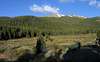
Hike the road until you reach the first in a series of meadows in the Silverheels Creek drainage. At the rear of this first meadow the road turns south, crosses the meadow, and climbs to a saddle on a minor ridge. My experience was that this meadow crossing is difficult to find under snowpack, but a tree stump at the crossing might make for a decent landmark. Try using this photo to aid in identifying the crossing. If the snowpack is deeper than the stump, I guess you're on your own!
After you cross the meadow, the road begins an ascending traverse to Silverheels' east ridge, which you'll attain after 2.5 miles of hiking. Once you're on the ridge crest (at a point with a marked elevation of 11,262' on the Como quad), hang a right, and you have 2.5 miles and 2500' on Silverheels' sweeping, gentle east ridge before you gain the summit. Return via your ascent route.
 |  |  |  |  |
Little Baldy Mountain (12,142')
Part of the appeal of this route is the chance to climb Silverheels' neighbor, Little Baldy Mountain as part of your day. While Little Baldy is a low 12er, it's stature is greater than you might guess. In fact, it has more than 1000' of prominence. Because it's prominence is determined by its saddle with Mount Silverheels, you're going to have to gain every bit of that thousand feet if you want to summit Little Baldy.
From the top of the road at 11,262' start hiking away from Silverheels and toward Little Baldy. You'll have to drop slightly before reaching the wooded saddle. The bushwhack across the saddle wasn't bad at all, in my opinion. Once you start ascending Little Baldy, you'll know it because its west slopes are steep! I thought it was better to stay slightly south of center on these west slopes to stay in the trees a little longer, and then hike on steep grass, but you might prefer the talus slopes a little further north. Enjoy the view from your South Park sentinel!
 |  |
Essential Gear
Hiking boots. Snowshoes during the snow season.