

|
|
Route |
|---|---|
|
|
40.08170°N / 105.6325°W |
|
|
Mountaineering, Mixed, Scrambling |
|
|
Spring, Summer, Fall, Winter |
|
|
Most of a day |
|
|
Class 4 |
|
|
II |
|
|
Overview
The East Ridge of Pawnee Peak is a challenging and enjoyable scramble on a mountain known for being gentle. The route ascends to the summit of Little Pawnee Peak with views into both the Blue Lake and Lake Isabelle drainages, then follows the serrated connecting ridge for a little under a mile of enjoyable scrabmling to the summit of Pawnee Peak. The ridge is fraught with gendarmes and cliffs so route finding is all part of the fun.Details:
Distance: 8 miles roundtrip (w/ descent of Pawnee Pass Trail)
Elevation Gain: 2800'
Difficulty: Class 4
Grade: II
 Pksander and Chris Gerber negotiate the short stretch of knife-edge.
Getting There
There are two drainages you can use to gain the East Ridge of Pawnee. I've done both and they are similar in difficulty. Both are described below.1. Long Lake Trailhead Approach
Begin at the Long Lake Trailhead. Follow the Long Lake trail to the west end of Long Lake (about a mile). Cut north and begin climbing the forested slopes of the east ridge until you gain the ridge. Once on the ridge proper, continue west along the ridgecrest until the climbing becomes interesting just east of the summit of Little Pawnee. This approach makes the descent easier, as the Pawnee Pass Trail returns to here.
2. Mitchell Lake Trailhead Approach
Begin at the Mitchell Lake Trailhead. Follow the Blue Lake trail for approximately 1.5 miles. You'll arrive at an area near treeline, on the north side of the East Ridge. There's a prominent and easy grassy gully that is easily visible when looking south from the trail. Find the path of least resistance through and around the creeks and bogs to the base of this gully and climb it to the ridge. Walk west along the ridgecrest until the climbing becomes interesting just east of Little Pawnee. This approach is the best option if you plan to climb Mount Toll and descend into the Blue Lake drainage.
2a. Northside Couloirs
There are a couple of interesting-looking couloirs on the north side of Little Pawnee that give you access to the ridge. Follow the route above, but aim for whichever couloir strikes your fancy.
Route Description
From where you gain the ridge, walk west on the crest to the summit of Little Pawnee Peak. This section is relatively short and is mostly Class 2 and easy Class 3, with a short Class 3+ downclimb into a notch that is slightly harder (probably harder for a shorter person).The summit of Little Pawnee is not immediately obvious amidst all the other lumps and bumps (look for the large white block with a summit register). From here, things get more interesting. Drop west off the summit, following the ridge to a large notch. We found the sharp narrow crest of the ridge to be the easiest line. It is steep and solid Class 4, but this section is short and there are ample hand and footholds to be utilized.
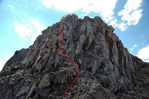
Class 4 section below Little Pawnee's summit
From here, continue west and down into the notch that often holds snow into summer. Scramble across the notch by either bypassing the tower on the left or downclimbing slabs to the right (north). Ascend out of the notch by utilizing an easy ramp just north of the ridge, or via the ridge itself (both are viable options). Drop down and north around the next set of towers, following the line of easiest resistance.
From here, continue following the ridge west, always dropping right (north) off the ridge to bypass the several steep sections. Eventually, things mellow out and the final 1/3 mile to the summit is an easy Class 2 walk.
Descent:
Descend via the Pawnee Pass Trail back to the Long Lake TH. If you started at the Mitchell Lake Trailhead you can climb Mt. Toll via the South Slopes then descend to Blue Lake and hike back out to the Mitchell Lake TH.
Essential Gear
Typical gear for Class 4 scrambles in the Colorado high country. An ice axe may be useful for crossing the notches along the ridge. We encountered steep snow in mid-June. A short rope may be useful for belays at a couple of points.External Links
Photo Gallery of June 8, 2006 trip.TundraCam
Niwot Ridge Weather Stations
Map
