-
 5239 Hits
-
 74.92% Score
-
 5 Votes
|
|
Route |
|---|---|
|
|
47.53528°N / 121.3658°W |
|
|
Scrambling |
|
|
Spring, Summer, Fall |
|
|
A long day |
|
|
class 2 |
|
|
Overview
This is the most popular route up the peak. That will all change once the gate at dingford is locked. It is about 8 miles round trip with over 4000' gain. the steepest section is the gully to gain the col to the North slope.
Route Description
Park .5 miles short of Middle Fork Snoqualmie River road. Plenty of parking.NOTE: a gate will be closed and locked permanently at Dingford Creek this fall. This will add 14 miles rt of road slog to get to the approach. One could bike to the trail head too.
From the parking area look north of the road for a path. The path takes you NE and then N along the left side of Hardscrabble Lake drainage. The path is easy to follow. After about a mile around 3500+’ the path enters a large boulder field. Cairns are placed so route finding is easy.
Once across the boulder field stay on the path. The path starts to steepen and one can get a bit off track here. There are a few other paths heading off to the left. Stay to the right along the creek. At about 1.5 miles you reach Hardscrabble Lake. Follow the left side of the lake across a boulder field. Great views of the Big Snow summit and the sheer walls of the east face.
From here head east find your way through the meadow at the north end of the lake. Find a path along the north side of the drainage from upper Hardscrabble Lake. The path is steep in spots but nice and easy to follow. It takes you up through forest, boulder fields, and then small meadows before reaching upper Hardscrabble Lake.
There are three different paths. One takes you to camping around the lake and then the other two take you up to the left side of the lake. We took the one to the left. I would recommend taking the one on the right. The left path vanishes and there are some cliff bands and brush bashing. The lower path that takes you along the lake and into the inlet area is much easier. These routes will dump you out at the base of a large talus filled gully.

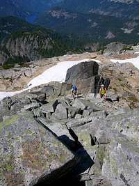
Follow the gully until it splits. You can take either gully from there but the one on the right is easier and a little less steep. The gully leads you to a col. One is rewarded with great views of the east ridge of Big Snow and north to the Glacier peaks and Monte Cristo areas.

Drop down or traverse low down to the northwest and begin picking your way through massive slabs of granite littered with rock and boulders. Many tarns and streams flow through the whole area. Great camping here!

Stay on the ridge till you reach the base of the summit block. From there turn south and ascend easy class 2 scramble to the summit. Enjoy the view!