|
|
Route |
|---|---|
|
|
41.93010°N / 123.1853°W |
|
|
Download GPX » View Route on Map |
|
|
Hiking, Mountaineering, Toprope, Bouldering, Scrambling |
|
|
Spring, Summer, Fall, Winter |
|
|
Half a day |
|
|
Moderate |
|
|
Class 4 |
|
|
Overview
Difficulty: Ranges from Class 2 to Easy Class 4Distance: Approximately 9 miles Round Trip if starting from the PCT
Elevation Gain: Approximately 1500 feet
The East Ridge route to climb the Red Buttes consists of climbing over loose talus slopes, to boulder hopping, to hiking through manzanita brush, to climbing pretty solid class 4 rock.
Views are astounding.
Getting There
From I-5 North or South near Medford follow signs West to the town of Jacksonville. Once heading in this direction for about 8 miles(highway 238) through the town of Jacksonville, you will reach the settlement of Ruch. Once in Ruch you will turn towards an Upper Applegate pointer for approximately 19 miles. At the end of Applegate Lake you will reach a T-shaped intersection. From here turn left onto Applegate Road for 1.2 miles to a gravel intersection. Continue straight on Road 1050 for 0.9 miles and then fork to the right onto Road 1055 for 10 more miles.Disclaimer: A High Clearance vehicle would be handy on this road but, if you are careful you MAY be able to get up it with a lower clearance vehicle. I personally would try myself because that is all I have. That being said, if you have a high clearance vehicle, you should use it.
AT THIS POINT YOU HAVE A COUPLE OF OPTIONS:
1. Park here and hike the Pacific Crest Trail approximately 3 miles to the base of the Red Buttes. Do this by taking the Pacific Crest Trail to your right as you enter the Parking lot area.
or
2. If you have a 4X4 (Absolute MUST for this option) you can take the steep, rocky, fairly exposed road for 3 miles to the base of the Red Buttes.
***NOTE***
If you choose to drive the road and you are using a 4WD truck, it will take you just about the same amount of time to reach the base of the Red Buttes as it will to take the Pacific Crest Trail. You will mainly just be saving your feet. That being said, if you have a 4 wheeler, you can probably shave off a lot of time.
Route Description
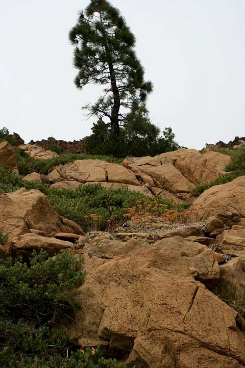
 This will be what you see at the starting point of the East Ridge
Once you reach the base of the Red Buttes, either via the PCT or via the 4WD road. You will start climbing up the Eastern Ridge towards the base of the Eastern Summit. This climbing will consist of some pretty fun boulder hopping as well as a few loose spots of talus slope. When you reach the base of the Eastern summit you will climb to your right through some manzanita brush and semi-loose slopes. Don't worry too much, a fall here shouldn't be fatal, but it may hurt a little. Once you round the base you will start climbing to your left towards the saddle accessing the Western summit. Reach this saddle and continue climbing left towards the summit. As you get closer to the summit it gets a little steeper and you should encounter some pretty solid class 4 rock. At the summit there is a summit register and a man-made windbreak built from the rocks just in case you wish to camp out up there.
Essential Gear
Summer:Good hiking/climbing shoes
Plenty of water
Compass
Pants (to keep from scratching your legs up from the brush)
Bug Spray (Best to climb in late Summer/early Autumn to avoid bugs)
Camera
Winter:
Cold Weather gear
Snowshoes
Crampons
Ice Axe
Avalanche knowledge
Rope (optional)
Pickets (optional)
Camera