
-
 5886 Hits
-
 76.66% Score
-
 7 Votes
|
|
Route |
|---|---|
|
|
35.22700°N / 106.45852°W |
|
|
Mountaineering, Trad Climbing, Scrambling |
|
|
Spring, Summer, Fall |
|
|
Half a day |
|
|
5.2 (YDS) |
|
|
Class 5.2 |
|
|
1 |
|
|
I |
|
|
Overview
For an excellent overview of "The Needle" check out the main page by hans.schenk. This route was originally rated as Class 4 but there is a consensus among Albuquerque climbers that this rating is incorrect and a rating in the 5.2 - 5.4 range is more appropriate.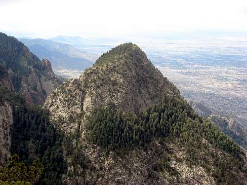 The East Saddle Route follows the obvious ridge in this photo
Facts
Distance - 1.5 miles (one-way to the summit)Trailhead Elevation - 10678'
Summit Elevation - 10260'
Gain - 400' (one-way to the summit)
Gain - 800' (one-way returning from the summit)
Approach
 A memorial marker located on the East Saddle Photo by: hans.schenk
Park at the top of the Sandia Crest ($3). The trail begins on the opposite side of the road on the east side of the radio tower fence.
Hike along the north Crest trail past all of the radio towers. Continue along this trail to a prominent bulge in the Crest. About 1.1 miles from the start at 35.226°, -106.453° you should be looking almost due west at the east saddle of The Needle. There are a few small carins here, marking where you can drop through the cliff band. Dropping through the cliff band may require a few Class 3 moves but it is not too difficult. Once below the cliff band follow the trail and carins as it switchbacks down the steep grade to the saddle.
 A view of the Needle from the Crest. This is the approximate area where you will begin the descent to the East Saddle. Photo by: hans.schenk
Route Description
 The first and crux pitch of the East Saddle Route (5.2) Photo by: hans.schenk
From the saddle hike east a few meters to the beginning of the ridge. The trees will clear as the ridge rises up from the saddle. The climb starts with a 30 meter pitch of climbing in the 5.2 difficulty range. The rock is fairly solid and has a few ledges along the way to help make placing pro easier. At the top of this pitch is a large ledge big enough for a number of people. There is a large tree on the climber's right that currently has an anchor built behind it on the rock. Use this anchor or build your own and belay from this ledge. Be careful since there is some loose rock at the top of this pitch to the climber's left. At this point the Class 5 climbing is behind you but you'll still want your rope for an exposed traverse. Once your party has made it to the belay ledge scramble up the Class 3 and Class 4 rock. The higher you go the more exposed the scrambling gets. Eventually you will find yourself on a very exposed notch in the ridge. At this point the rock only continues up for another 5 meters before dropping off in a sheer cliff. Looking directly down to the climber's left from the notch you should be able to see a tree with many rappel slings around it. This is the beginning of the traverse and you'll want to build an anchor here. Although the traverse is only about 20 meters of Class 3 it is very exposed and we all liked the extra security of the rope. The first move of the traverse is to drop down a few feet then make your way to a large ledge with an aspen growing on it. Careful of the first few moves; there are a few large blocks that make great hand holds but some are loose. The aspen tree is the halfway mark of the traverse but the moves after this are a bit easier. At the very end of the traverse you will find yourself on a second saddle. Once your party has completed the traverse stay to the climber's right and head up the slope along the base of a small cliff band. At this point it is all Class 2, just continue uphill, tending a bit to the left until you find the summit and the spectacular views of the city and the Sandias.
Descent: Hike back to where you ended the traverse and retraverse the same section. It is slightly easier in reverse since the last few moves you are climbing up, instead of down climbing. After the traverse downclimb the Class 3 and Class 4 rock until you reach the large ledge with the tree and rappel anchor. Rappelling this pitch will put you back at the base of the climb and the east saddle of The Needle. A single 60m rope is long enough for this rappel.
 A marked overview of the East Saddle route on the Needle. If you can't read the captions click on the picture for a larger view. The red circle in the picture indicates the Aspen tree at the midway point of the traverse.
 An overview of the technical portion of the Needle
davebobk47 - Aug 2, 2010 1:54 pm - Hasn't voted
WebbingThe old webbing has been removed. I climbed 8/1/10 and left a new piece of blue webbing for rappelling.