
|
|
Route |
|---|---|
|
|
40.79575°N / 110.46635°W |
|
|
Hiking |
|
|
Summer, Fall |
|
|
A long day |
|
|
Class 3 |
|
|
Overview
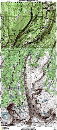 Map of route
This route describes a hike to a remote and seldom climbed peak, 12566, in the Uinta Mountains of Utah. Peak 12566 is located on the Red Castle ridge which lies between Red Castle Lake and East Red Castle Lake. It is one of the three rugged peaks on the north end of the ridge.
The route ascends a steep couloir on the east side of the peak that leads to the saddle south of the summit. The south ridge is the only way to get to the summit without running into a cliff. The couloir is loaded with loose rock and maxes out at 40 degrees.
Most of the route is on an easy to follow, well maintained trail. There are no difficult creek crossings. The three major ones are bridged.
Stats
Start elevation: 9440 feetSummit elevation: 12566 feet
One way mileage: 12 miles
One way trail mileage: 11 miles
Elevation gained on trail: 1680 feet
One way off trail mileage: 1 mile
Elevation gained off trail: 1446 feet
Getting There
The route starts at the China Meadows Trailhead, located about 4 miles west of Henrys Fork, the major gateway to Kings Peak, the highpoint of Utah. For driving directions see the Getting There section for the main page.Route Description
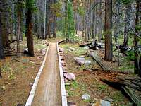 The trail The trailStart from the China Meadows Trailhead. Follow the East Fork Smiths Fork Trail 9 miles. The trail is heavily forested and you won't get your first glimpse of Red Castle until you reach the second bridge at 7.45 miles from the start. |
 Heading around the north side of E Red Castle Lake Heading around the north side of E Red Castle LakeWhen the trail splits to go around Red Castle turn left onto the East Red Castle Trail and immediately cross a bridge. Go another 2 miles to a small stream at N40 47.997 W110 27.033. The East Red Castle Trail crosses the stream and continues to Smiths Fork Pass. Instead of doing this, make a right turn onto a small path just before the stream and head to the far end of East Red Castle Lake. The path fades out but it is easy cross country travel to the lake. |
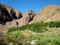
 12566 is the big bump right of center 12566 is the big bump right of centerFrom the lake, head to the base of the couloir that is south of Peak 12566. |
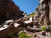 Getting close to the saddle Getting close to the saddle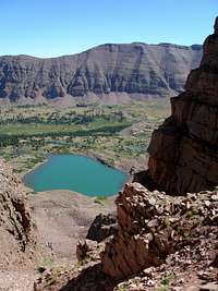 Looking back Looking backHead up the couloir to the saddle south of the summit. Looking back is a nice view of East Red Castle Lake and Mount Powell. |
 The other side of the saddle The other side of the saddle Pillar PillarUpon reaching the saddle, turn north and follow the ridge to the summit. Just north of the saddle is an interesting pillar that is easily passed on the east with a minor amount of exposure. |
 Just after pillar Just after pillar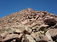 The rest of the ridge The rest of the ridgeJust after the pillar the ridge is very steep for just a short distance. Then the terrain moderates and it is a straight forward boulder hop to the top. |
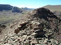 Looking back at summit Looking back at summitThe actual summit is on a narrow boulder strewn ridge. The highpoint is on the south side which is what you will get to first. |
Essential Gear
I used a helmet. Other than that, nothing special is needed after the snow is gone. For a snow climb, crampons and an ice axe are essential.Commentary
I rated this route as class 3 but class 3 does not mean easy nor does it mean safe. Getting up the scree in the couloir was tough. Most of the time I could make slow but steady forward progress whether uphill or downhill, but every so often I'd have to stop and think about where I could possibly place my foot so that I would not unleash a torrent of loose rock. On the way down I rode out several small slides.There were few if any large blocks on the slope so if anything does slide on you it will likely be less than 12" in the largest dimension.
On the way up I only heard one loud clatter of rock fall. On the way down I heard several and when I took a break at the bottom I heard so many that I decided I wasn't in as safe of a spot as I thought so I packed up and continued my break at the lake. Most of the clatters sounded like they were coming from the eastern end of the cliffs of 12825, but not near the couloir.
While in the couloir I saw small stuff trickle down the sides several times but all of this was less than 1" in diameter.
I had planned to stay in the middle of the couloir but in practice this didn't work out too well because the footing was so much better on the south side, right next to the wall, where there was often a fair amount of dirt mixed with the rock. Near the saddle, it gets less steep and I switched to the other side.
There is virtually no exposure on this route. Just a bit when going around the pillar. But, no exposure does not mean you won't get seriously injured if you slip. The couloir is steep enough that if you fall and get rolling you may not be able to stop for a very long way.
Cresting the saddle and viewing Red Castle Lake on the other side takes your breath away, even when you know it's there. I can't imagine what it would be like if you didn't know what was on the other side.
When to Climb
 The east side couloir is exactly in the middle
The best access is mid June through the end of September. Before mid June, the approach might not be melted out. The mosquitoes seem to disappear by the end of August.
I did it late summer when all the snow was completely gone. It was difficult making it up the couloir with all of the loose rock. The picture at the left shows the couloir at the end of June, with the approach completely melted, but still lots of snow in the couloir. It looks like it would be a good snow climb and would be a lot easier than fighting the scree.