
|
|
Route |
|---|---|
|
|
37.63440°N / 118.2547°W |
|
|
Hike/scramble |
|
|
One to two days |
|
|
Very long walk-up, some class 2 scrambling |
|
|
Approach
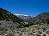
This is probably the only route on California's fourteener that begins practically in the town center if town of Dyer may be qualified as such.
Directions:
Drive to Benton either from Bishop or from Lee Vining. From there go on Hwy6 east over the Montgomery Pass until the jct with Hwy264 (23.5 mi). Turn right and drive south on Hwy264 for 24.5 miles arriving to the town of Dyer (you can also drive from Bishop via Big Pine on Hwy168). There are many side roads there mostly going to the local farms. Look for the mouth of the Perry Aiken canyon: the road there starts to the right of it. The road is of miserable quality, especially last two hundred yards and it will bring you at most one mile closer to the canyon still within town limits.
Route Description
Total one-way distance from the road's dead end: 14 miles
Total elevation gain: appx 10000 feet.
These values may slightly vary depending on your luck with routefinding and final approach to the East Ridge.
There's a faint use trail that goes in the canyon and it grows even more fainter towards the upper reaches. In fact it is more or less discernible just for the first 5 miles and then it's more like occasional footprints. Still it'd save you some time if you try to follow it.
The trail does not start at the road end. You have to climb cross-country on the broad terrace on the left (here and afterwards the sides are given orographically, ie standing downstream) bank of the canyon and follow the edge of the terrace until you hit trail (it begins somewhere in the town). The first part of it (2.2 miles) until the junction of North and South Forks of Perry Aiken is pretty annoying: the canyon is narrow, the trail jumps from bank to bank without warning and chances are you'll be bushwacking half of the way. At the junction cross the stream and go into the canyon of North Fork of Perry Aiken creek.
Next 3 miles the going is easy on broad open terraces of North Fork canyon, but it may be very hot in summer. At 1.5 miles from the junction, the trail crosses the stream and remains on the left bank till the end. After 3 miles, the canyon narrows down, trail virtually disappears and you find yourself for the next mile bushwacking, skirting steep slopes, crossing numerous ravines and finally arriving to the terminus of the canyon. This is where the real hell begins.
From here you have three choices. You can climb to the left hanging valley which is a main branch of the North Fork arriving to the East Ridge from south, you can continue straight ahead along the north branch of the North Fork or you can climb right onto Perry Aiken flat. I chose the latter because the main branch ascent was not visible till the end and the north branch looked horrible. The going here is quite difficult: numerous streams are running in troughs with vertical walls overgrown with raspberry and other prickly stuff, every crossing takes a lot of scratches and swears. The final climb to the flat is 1500 vertical feet and it is a continuous steep bushwacking.
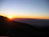
There are nice tent sites at the edge of the flat (10200 ft) but there's no running water. The place is really beatiful - you can spend ages there just watching sunsets and sunrises.
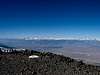
The summit day is easy and pleasant comparing with the approach. Follow the edge of the flat for appx 1.5 miles (elev. 11300) until you see an easy traverse into the hanging valley which terminates north branch of the North Fork. It is tempting to follow the ridge from the flat, but it goes over several intermediary summits with drops after each and the final ridge below the main summit is narrow and treacherous. Continue in the valley until you reach the obvious pass between the main and north branches of the North Fork (12200'), turn right and face an obvious ridge that goes to the main summit. There's nothing but walking and little scrambling there. Ridge ends (13500') at the broad summit slope. The summit seems deceptively near from there, but it's still 700 vertical feet and five crossings of summit road left. Make a mental, GPS or any kind of other note of the place where you exit the ridge! The edge of the plateau is practically featureless and it is very easy to drop into wrong undescendable chute on return trip (which I did).
Enjoy the views from the summit and prepare for a long way back.
There's an alternative approach to the Perry Aiken flat which I considered for return trip: from the Leidy canyon. It has some kind of 4wd road and mapped trail in it, though it is hardly shorter.
 |  |  |  |  |
Essential Gear
Water maybe a problem late in summer - bring a lot. Dress in something sturdy - there's a lot of prickly stuff.
Miscellaneous Info
If you have information about this route that doesn't pertain to any of the other sections, please add it here.
 |  |  |
LADave - Jan 11, 2007 6:59 pm - Hasn't voted
Leidy Canyon easierIt's much easier to get up to Perry Aiken Flat from Leidy Canyon. The way is pretty clearly marked on the topo. With a 4x4 you can drive pretty far up. In fact I took my old Fork Maverick as far as an old rockslide that's only about ten minutes' walk below the 4x4 trailhead. A short distance above the 4x4 trailhead follow the ramp-like jeep road to the left. It brings you to an open cowpasture with a corral with two gates. A good trail up to Perry Aiken Flat leaves from the uphill/smaller gate. This trail switchbacks up onto the ridge, then follows the whaleback ridge with moderate grades. Near the upper treeline for Bristlecone Pines you can traverse left into the north branch of the north fork of Perry Aiken Creek, which is a cirque on the north side of White Mountain Peak at this elevation. There was ample water in this cirque when I was there in early summer. It's a great place to camp and explore, as well as a base for dayhikes up to White Mountain Peak via the dividing ridge between this cirque and the main north fork to the south. You can also backtrack to the whaleback ridge and follow it up to peak 13,9xx which is separated from WMP by a difficult knife-edge ridge.
Little Mountain Goat - Jun 4, 2008 8:22 pm - Voted 10/10
Re: Leidy Canyon easierHow high is high? Also, how high is that cirque
LADave - Jun 25, 2010 5:23 pm - Hasn't voted
How high...I didn't have an altimeter along, but trying to recreate it with online maps I'd say you can drive up to 8,000' at about 37.702N, 118.221W. http://www.digital-topo-maps.com/ makes it look like the jeep road goes all the way up to Perry Aiken Flats, but it's really just a foot-trail (or cow trail) above 8,000'. If you sidehill over from Perry Aiken Flat, you'll hit the cirque at about 11,500'. You can stay pretty much on the cirque floor up to a low ridge at 12,400' separating this cirque from the much deeper cirque of the main North Fork. Above that the headwall goes up to about 13,600' before you're out on the cirque on more moderate slopes. When I was there in July the cirque floor was well watered. In fact it was boggy in places. It would make a great campsite and you could then explore the upper slopes of White Mountain Peak and Peak 13,980 at leisure. All in all, a much easier route that going up Perry Aiken Creek but keep in mind that it gets you into the cirque of the Northwest Fork, not the much deeper North Fork, although you have excellent views down into it.