
|
|
Route |
|---|---|
|
|
40.36850°N / 105.64502°W |
|
|
Hiking |
|
|
Spring, Summer, Fall, Winter |
|
|
Half a day |
|
|
Class 2 |
|
|
Overview
 View along the East Ridge of Beaver Mtn.
This is the typical route to the summit of Beaver Mountain from Upper Beaver Meadows Trailhead.
Getting There
Start from the Upper Beaver Meadows Trailhead.Route Description
Stats: Class 2, 6.3 miles (round trip), 2241 feet of elevation gain.100 feet from the trailhead, you will be confronted with an option to go right (west) or straight (south). Either trail can ultimately be taken to get to the 0.5 mile point, but for the purposes of these directions go right (west). This is actually the start of the Ute Trail, which ultimately leads all of the way to Fairview Curve on US 34 on the west side of the Continental Divide. After about 600 feet, there will be a fork in the trail. Take the left fork (the right fork leads to a ranger cabin). After 0.5 miles a spur trail from the Beaver Meadow Loop Trail joins the trail that you are on from the left (east). After a total of 1.5 miles leave the Ute Trail by going right (north) onto the Beaver Mountain Trail. Continuing straight would take you up to Trail Ridge Road on the Ute Trail. Continue on the Beaver Mountain Trail as it wraps around the east side of Beaver Mountain. After a total of 2.0 miles the trail will start to head downhill. Go downhill about 0.1 miles to a horse hitch. This is where you leave the trail and head northwest up the east slope of Beaver Mountain. The coordinates of the point that you leave the trail are 40.36505°N / 105.62645°W and the elevation is 9,120 ft. Head northwest up the east side of Beaver Mountain. At 9,900 ft. you will encounter a rocky ridge. Navigate across the rocks of the ridge, then head west and climb the remaining 600 vertical feet to the summit. |
Trail Profile and Map
The trail color represents the class of that portion of the trail.Green = Class 1
Blue = Class 2
Trail Profile The vertical unit is feet, and the horizontal unit is miles.  |
Map Note: The location of the Ute Trail on the topo map is incorrect. The first 1.5 miles of the route drawn in green shows the correct location of the Ute Trail. 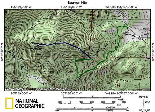 East Slope from Upper Beaver Meadows TH. East Slope from Upper Beaver Meadows TH. |