
-
 3378 Hits
-
 71.06% Score
-
 1 Votes
|
|
Route |
|---|---|
|
|
46.59340°N / 11.82310°E |
|
|
Hiking, Mountaineering |
|
|
Summer, Fall |
|
|
A long day |
|
|
Walk-up |
|
|
Overview
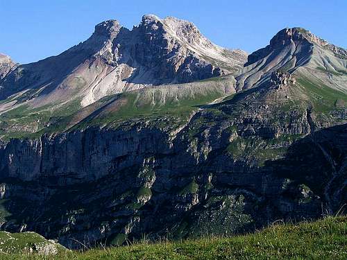
This route reaches one of the main summits of Geisler-Puez Group in Dolomites. On the tour we are hiking by an interesting landscape, finale is the ascent on a panoramic, a bit remote summit.
New section
Difficulty: From the Puez hut just a hike-up. On the Swiss Hiking Scale its difficulty would be graded with T3. The last part is quite steep, but not exposed. The trail is well marked.
Slope orientation: The ascent slope is south-east oriented, the foresummit 2725 m is crossed by its western slopes.
Objective dangers: In summer conditions there are not many.
Best season: Summer months, normally from July till October (or first snow).
Gear: Good, sturdy shoes and poles.
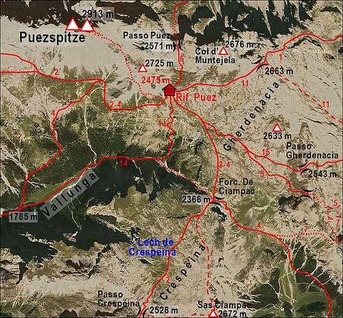
Tour start: Rif. Puez, 2475 m. See the parent page how to get there!
Highest point: 2913 m.
Altitude to overcome: cca 450 m.
Time for ascent: 1 h 30 min.
Route Description
From Puez hut we go westwards by the Dolomiten Hohenweg (Dolomites High Route), but immediately deter right, upwards towards Col de Puez (NW direction). Over grassy slopes we reach the southern shoulder of Col de Puez, go by its ridge upwards (towards the N) and reach the upper saddle, just below the hill.

Now our marked path starts crossing the southern and western slopes of Col de Puez. The path is narrow, on a few places unpleasant (hard debris doesn't enable to find good steps), leading horizontally on the broad sadlle between Eastern Puezspitze and Col de Puez (2630 m). Here the steep part of ascent begins.
The marked path goes in many turns left of screes upwards, touches the edge of the southern vertical drops, but then leads us without problems further on. On the upper part, the path is steep, finally we reach the notch just below the summit. The northern horizons open. The right summit is lower, so we turn left and in a few minutes reach the summit of Eastern Puezspitze.
To continue the crossing towards Western Puezspitze would be by my estimation more difficult. The summit of Eastern Puezspitze is falling vertically to the notch between both summits.
We return by the same route - but - don't miss very pleasant screes, which can take you some 200 m down towards the saddle. So the descent is fast and joyful!

|

|