
|
|
Route |
|---|---|
|
|
38.14900°N / 119.627°W |
|
|
Hike / Scramble |
|
|
One to two days |
|
|
Class II |
|
|
Approach
Peak 10431 is located on the boundary of NW Yosemite and SE Emigrant Wilderness Area. Directions from the closest trailheads to ascend the eastern slope are listed below.1) From Leavitt Meadows Pack Station, follow the West Walker River trail south until you reach the Cascade Creek trail. Follow the Cascade Creek trail until it joins the PCT. Follow the PCT south over Dorothy Lake Pass and past the signed junction of the Bond Pass Trail. Continue south on the PCT into Grace Meadow until due east of Peak 10431. The ascent starts here. The GPS coordinates are 38,09,93N by 119,36,69W. (21 miles total)
2) From the Leavitt Lake trailhead, follow the Leavitt Pass trail south, up and over Big Sam, for 10 miles until you reach Emigrant Pass. Take the trail split to the south. Near Grizzly Meadow, you can take 1 of 2 routes that lead to Bond Pass. The Bond Pass High trial is a bit more scenic. Or you can take the trail that borders Summit Meadow. Continue east past Bond Pass. Turn south on the PCT until you get to Grace Meadow. The ascent starts here. The GPS coordinates are 38,09,93N by 119,36,69W. (18 .5 miles total)
Route Description
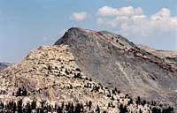
From the GPS coordinates listed above, leave the PCT at Grace Meadow and head due west cross country towards Peak 10431. This is a moderate ascent through trees with mixed dirt, gravel and rocky terrain. You will emerge from the trees at around 9800 feet. The final ascent begins just NE of the summit. The route follows the line of bushes up to the summit from NE to SW as depicted in this photo.Disclaimer: I've not climbed this route yet. However I've been on all sides of this mountain. From the photos I've taken and topo map, it looks like an easy class II ascent.
Start elevation: 8,800'
Summit: 10,539'
Elevation gain: 1,739'
Distance: 1 mile from the PCT
 |  |