
-
 11788 Hits
-
 78.27% Score
-
 9 Votes
|
|
Route |
|---|---|
|
|
44.93051°N / 111.46003°W |
|
|
Mountaineering, Scrambling |
|
|
Summer |
|
|
Most of a day |
|
|
Class 4-5, Serious Exposure in the Hardest Places |
|
|

Overview
From a base camp near Echo Peak, Dutchman Peak, or Hilgard Peak, one can fill most of a day with this fine scrambling/mountaineering route.
Let's be clear from the outset, though-- you can easily get yourself killed on this route because it is not difficult enough that most would carry ropes but is nonetheless dangerous. Unless you decide to lose a tremendous amount of elevation gain by descending into the basin beneath Dutchman and Hilgard, in which case you would not really be doing a traverse of all three peaks, you will find the traverse across the east face of Hilgard Peak to be an exercise in route-finding and death-assuring exposure. At the very least, you will find yourself on loose, exposed Class 4 terrain; more than likely, you will at times find yourself on loose and exposed Class 5 terrain.
But if you're okay with all that, then this is one of those days that scramblers live for.
Getting There
You can do this traverse in either direction, but I did it from north to south and thus will describe it that way.
Between Earthquake Lake and Hebgen Lake, turn off U.S. 287 onto signed Beaver Creek Road (FR 985). Drive about 4 miles to the road's end at Potamogeton Park. Two trails depart this spot. Use the first, more southerly one, not the one over by the pit toilet. The trail you want is the Sentinel Creek Trail, and it accesses Expedition Pass and Hilgard Basin, the latter of which is a highly scenic backpacking and fishing destination.
This road is a little rocky in spots but is suitable for most passenger vehicles.
If you are going to approach Hilgard via the standard approach, then you will park a mile south and use the west fork of Beaver Creek when starting out. Please see the Hilgard page, as well as the route page for the east ridge, for more details.
Route Information
At the Sentinel Creek TH, a sign says it is 8 miles to the turnoff for Hilgard Basin. Thomas Turiano, author of Select Peaks of Greater Yellowstone, puts it at 7. My pace suggested it is closer to six, but let's split the difference and call it 7 miles.
Anyway, follow the trail until an intersection close to timberline. Bear left for Hilgard Basin. This intersection is NOT where the USGS Hilgard Peak quad shows it; it is higher up.
From the divide above Hilgard Basin, descend and then pick a campsite somewhere in the basin. The divide is at about 9800'; the lowest point in the basin is at about 9400'. If you're going to climb Echo first, then it probably makes most sense to camp at Expedition Lake or Crag Lake.
Ascend Echo via either the north ridge (Class 3, described on the main page), the northeast face and east ridge (Class 3, described in an attached route page for the main Echo page), or the rugged east ridge (at least Class 3).
Let's get started.
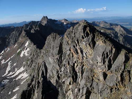
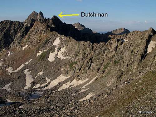
From Echo, follow the ridge south. There is a substantial amount of Class 3 terrain, some of it bordering on Class 4. Approaching the summit of Dutchman, I found that the terrain steepened to Class 5 conditions, so I passed below the summit on the west side and wound up at a notch above an east-facing gully just south of the summit block. From there, I descended a short distance and then was able to access the eastern face of the summit. Class 3/4 scrambling got me to the top.
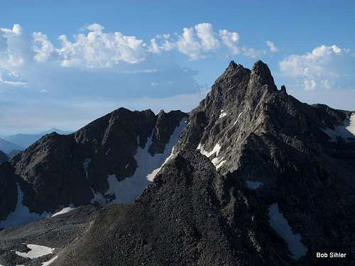
After descending Dutchman's summit block and regaining the ridge, continue south and over Point 10,780T, which on its north side has the prominence to qualify as a ranked peak but on the south side does not. Then drop to the saddle between 10,780T and Hilgard.
Now things get interesting.
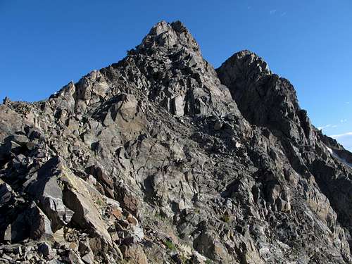
Throughout the day, you will have noticed the lower, rugged peak just north of Hilgard's summit. This peak is known to many as North Hilgard, and it is far more challenging to climb. Yes, it has been climbed. Yes, some have made the traverse between the two summits of Hilgard. But no, do not plan to make this peak part of your traverse unless you've brought climbing gear. Do not even, as I did, bother scrambling to its base in hopes of finding a way to traverse across its eastern or western face en route to Hilgard. Such a bypass does not exist; the east face is bad enough, and the west face is so wildly exposed (and beautiful) that one look at it will both inspire and terrify you.
So instead, from the saddle, study the east face of Hilgard and plot a tentative course across it to reach the notch at the base of the east ridge. Turiano mentions that there is a Class 4 way across the face, and he is right, but it may take a lot of time to find the correct route, and I know that many have failed and either given up or gone back to the saddle and dropped into the basin. More than once, I had to change course after getting onto badly exposed Class 5 terrain, much of which was wet and slabby. I will not even attempt to describe my convoluted route, but I will repeat that it is exposed Class 4. Eventually, I did make my way to that notch.
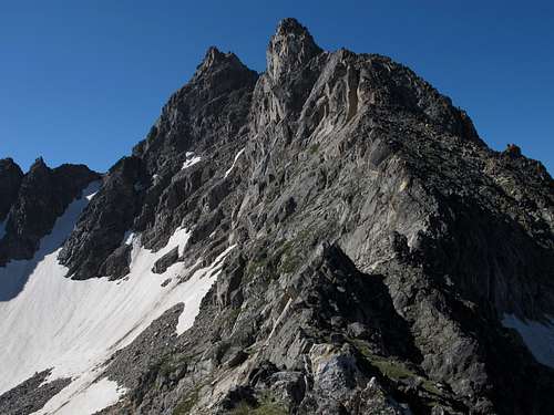
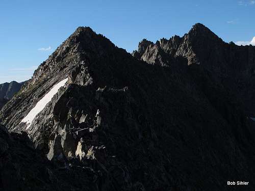
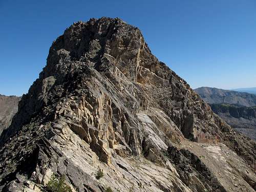
East face of Hilgard
From the notch, you are on the standard east ridge route for Hilgard.
The rest of the way is not as long, hard, or scary as you might have been led to believe by some online and published accounts. As you head up the ridge and move through a narrow gully or couloir, it steepens into Class 5 terrain, but there are at least two ways around that spot. Then things get more exposed and you reach the knife-edge that leads to the summit block. The traverse of the knife-edge is described as 5.2, but I really think it's only arguably Class 4. However, the exposure on the north side of it is not to be argued with, and it may account for the rating even though it shouldn't.
For anyone not liking the knife-edge, though, there is an option to drop below it on the south side and then scramble up to the summit block.
To return, don't retrace your route. Go back to the notch. You can descend directly from the notch via a steep couloir. In late July, I found it entirely filled with snow. Although I had an axe, I did not have crampons and felt it was too steep to glissade or to try walking down without crampons, so I wandered east a bit to some couloirs I had seen earlier and which looked less steep and had less snow in them. I used one of those couloirs to descend into the basin.
The map below shows the peak and the basin below it. The upper "arrow route" is the way to Hilgard Basin.
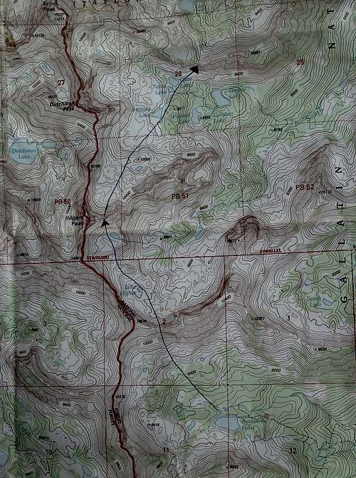
The upper basin is a boulder field and can be slow going, but there are no major obstacles. Head north across the basin to Hilgard Lake and then continue north to Tallus Lake and Clear Lake. Then go up boulders and steep talus to an obvious notch northeast of Clear Lake. This notch is on the divide separating the basin below Hilgard Peak from Hilgard Basin proper. From that notch, locate a trail; this is the trail through Hilgard Basin.
The col above Clear Lake
The Route in Pictures
Ridge between Echo and Dutchman
Between Echo and Dutchman
Dutchman
North to Echo
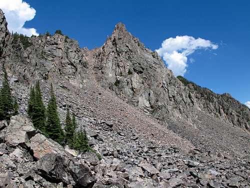
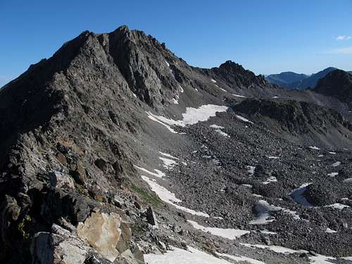
To Hilgard from Dutchman
Point 10,780
Distances and Elevation Gain
TH to Expedition Lake-- about 7.5 miles.
Expedition Lake to Echo-- about 2-3 mi depending on exact route.
Echo to Dutchman-- about 1.3 mi (per my GPS).
Dutchman to Hilgard-- about 1.7 mi (per my GPS).
Hilgard to the divide between Hilgard's basin and Hilgard Basin proper-- 3.2 mi (per my GPS)
Divide to Expedition Lake-- about 2.8 mi (per my GPS).
So on climbing day, you are looking at 12 miles, which is not much, but consider that it is mostly off-trail terrain with a lot of scrambling. Start early, be prepared for a full day, and keep an eye on the weather; storms develop suddenly here.
Trail elevation gain to camp is about 2600' (remember that you will gain up to 400' when hiking out).
On climbing day, elevation gain will be in the vicinity of 3700'.
Essential Gear
Helmet, axe, and crampons. Even in late summer, you will likely find snow in the couloirs, and it may be icy.