
|
|
Mountain/Rock |
|---|---|
|
|
48.55780°N / 118.5362°W |
|
|
Hiking |
|
|
Spring, Summer, Fall, Winter |
|
|
6560 ft / 1999 m |
|
|
Overview
In memory of Ed Miller, who would have been 50 last month (April 2007)…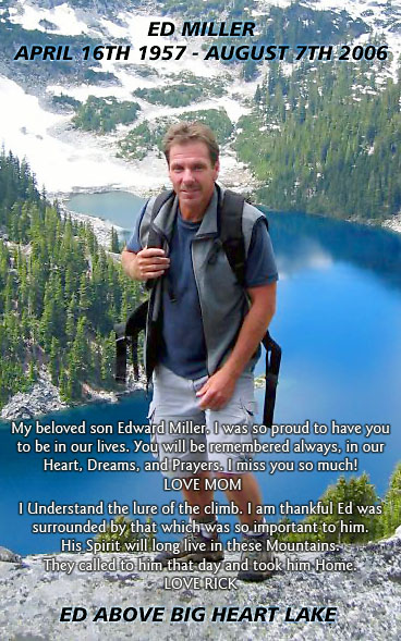
Ed Miller went by the handle Edd on NWHikers.net (he was rialtosol on summitpost). And though he has traversed on to climb those endless mountains in the heavens, we here remain Earthbound where we carry on the torch of his being with the Ed Miller Traveling Summit Register Memorial. I personally only met and climbed with him once (on Whitehorse Mountain) but he was such a nice guy how could I not consider him a friend after just one encounter?
I originally spotted the Edds Mountain Quad on Jeff Howbert’s site last year while searching for some other peak(s). And there it was, Edds Mountain, just waiting for me to go over and climb it. And the stars would finally align last week. I had a few other objective peaks in Eastern Washington to do and it seemed like a good time for Michelle and I to take a trip over there (Michelle had up to that time never seen Eastern Washington). As Michelle and I were hiking cross-country up the west slope, the wind was whistling through the forest fire snags. The sound was eerily similar to distant coyotes howling. But to us we imagined it was Ed’s spirit serenading our ascent. As we were climbing up we were even blessed with a light snowshower.
Edds Mountain is part of the Kettle Range between Kettle Falls (Columbia River Valley)) and Republic (Sanpoil River Valley). Though it is not nearly the highest summit on that high divide (it ranks about 12th and about 25th overall in Eastern Washington), it does provide for a nice view* of the peaks lining the southern half of the range, peaks ranging from Columbia Mountain south to White Mountain. The west slopes are semi-open but annoyingly strewn with blowdowns. On the upside, there is plenty of low lying granite to ease the eye and the travel. The summit rocks are not granite, however, but schist of the rusty variety.
* The whole of the area west and southwest of Sherman Pass (Highway 20) including most of Edds Mountain was burned in the White Mountain Fire of 1988. Short pines (replanted?) are growing on the east slope. Eventually I suppose these trees will block the views. But it will be several years before that happens.
Here are some trip reports for Edds Mountain (wta.org)
Getting There
Edds Mountain is located in the southern half of the Kettle Range in the Columbia Mountains of Northeast Washington. The mountain is 10 miles ESE (and 4,000 feet higher) than the town of Republic. There is a trail that goes to within a quarter mile of the summit. It’s called the Edds Mountain Trail and it continues on to higher Bald Mountain where it connects with the Kettle Crest Trail.There are a few logging roads that lead to the vicinity of the trailhead but I will not mention them all here. I will only mention the most obvious route. You can read a map if you wish to make a shortcut (say from Highway 21 via McMann Creek Road).
From Republic drive about six miles out of town eastward on Highway 20 to Hall Creek Road (which doesn’t go up Hall Creek at all; in fact, I don’t even see a Hall Creek) on the right. The Edds Mountain Trail is well-marked at the turn. Continue up the road (goes southeast then east up South Fork O’Brien Creek) for about four miles, passing a lovely* meadow at about three miles. You’ll pass a narrow road called Rabbit Road (does this mean the road goes under the bushes?). The road to the Edds Mountain Trail is to the left shortly thereafter. Drive for about 1.3 more miles to an end and the trailhead at a junction (4,360 ft). This is the new trailhead thanks to local horsemen. The old trailhead used to be a mile to the south and 500 feet higher on the west ridgeline of Edds Mountain. But I guess this was simply too close. It’s not as if the road is in bad shape and we could have driven it except for one minor washout at the creek crossing.
* lovely except for the trashy house and derelict cars.
Edds Mountain Trail
The well-marked trail begins at 4,360 ft. It initially follows the old road for two miles and two switchbacks up to the ridgeline at 4880 ft, whereupon it turns left (east) and goes for about 1.5 miles up and over the high south shoulder of the mountain. A short and easy cross-country stroll will get you to the top, which is slightly beyond a shield-shaped open expanse (in case you’re in a whiteout when you get there). The summit is the first of two outcrops of schist. No register was found. There may be a benchmark a little farther north on the summit plateau. This would be the origin of the 6550T mark on the map. But the highest contour is 6560+.Shortcuts
It is possible to go crosscountry from the first switchback (4,400 ft) to avoid the long out and back of the second switchback. This shortcut is recommended. There is even a rudimentary bovine trail through here. It dumps you out a couple hundred yards short of where the road crosses the creek.
It is also possible to hump straight uphill from the creek crossing, either going due south to the ridgeline (to meet the trail) or east toward the summit. The latter is not recommended (this is the way we went). Brushy trees near the creek convey you progressively northeastward to the nondescript northwest ridge. Here we encountered exasperating blowdowns that negated any time savings. This direct route might be better if there was quite a bit of snow.
Camping
Not applicable. This is a day-hike. You can continue on to do a Kettle Crest traverse if you like.Red Tape
None. No Trail Park Pass required.When to Climb
Given the resolve to make a longer approach, you could even climb this peak in the winter. But any other time of year is perfectly fine. In the spring time you might night be able to get all the way to the trailhead. In late April (2007) we encountered one residual shaded spot with snow about a quarter-mile from the trailhead.Mountain Conditions
Republic weather forecastLocalized NOAA forecast