
|
|
Mountain/Rock |
|---|---|
|
|
46.68450°N / 25.82600°E |
|
|
Harghita |
|
|
Hiking, Trad Climbing, Skiing |
|
|
Spring, Summer, Fall, Winter |
|
|
5276 ft / 1608 m |
|
|
Overview
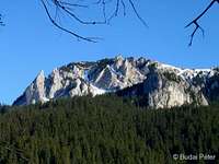
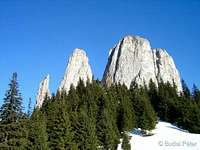
Egyeskő is located in the limestone range of Hagymás/Hăşmaş Mountains (Eastern Carpathians). The rock's name ("single/singular rock") is slightly confusing, as it is actually a group of several towers and needles. However, these jump out of the surrounding terrain quite steeply, making them a very distinct block (thus, "solitary rock" is a better translation). Different sources give different height for the rock, I have seen 1587, 1608, and 1648 m as well - these probably refer to various towers of the group. Recent GPS measurement of the tower which has a metal cross on its top resulted 1577 m, however this is not the highest point of the group.
For its picturesque setting, relatively easy access and accommodation possibilty, Egyeskő is one of the most popular attractions of Hagymás Mountains. Though the rock can be climbed without gear, it is far from being a "walk-up" session, especially the top section. Egyeskő is a nice place for trad climbing as well. Two important Transylvanian rivers (Maros/Mureş and Olt) originate in the broader area (about 10 km away from Egyeskő).
Getting There
The most straightforward approach is from the town of Balánbánya/Bălan. The most comfortable approach of the town is by car. The nearest train station is about 10 km away in Csíkszentdomokos/Sândominic (station name is Izvoru Oltului). From there buses go to Balánbánya/Bălan.
If you come by car (have a look at the Miscellaneous section about road toll), take road 12 until the village of Csíkszentdomokos/Sândominic (about halfway between Gyergyószentmiklós/Gheorgheni and Csíkszereda/Miercurea Ciuc towns). Here, take the road that stems out to Balánbánya/Bălan. After entering the town, just continue on the same road. You will pass by block houses, then get into the center. Look out for a church on the right side (there is also a parking sign). Take a right turn here into Kovács-patak utca / str. Pr. Fierarului. There is a parking place for about 10 cars - if it's full, you must look for another suitable place nearby. From here you shall continue on foot.
Follow the street along the Kovács-patak/Pr. Fierarului creek - soon you'll get the blue stripe sign, which leads up to Egyeskő. The trail starts with a steep ascend in the pinewood forest (and it will keep ascending along a ridge almost all the way). In about one hour the NW part of Ecsém-tető/Ecem will show up its fascinating rocks through the woods, with the rockslide in its side called Ördögmalom/Moara Dracului (Devil's Mill). In front of Ecsém-tető you will see Vigyázó-kő/La Pândă (Sentinel Rock). After this, the trail flattens out and swithes to the other side of the ridge, this is where you will get the first glimpse on Egyeskő. After crossing a little stream the trail turns left under a big rock (in the forest). Soon it joins a wider open path (turn right, upwards). A few more turns and on the top of the last slope the trail reaches the hut (see the Camping section below) at the feet of Egyeskő.
 NW Ecsém-tető and Vigyázó-kő from the trail NW Ecsém-tető and Vigyázó-kő from the trail |
 first view of Egyeskő from the trail first view of Egyeskő from the trail |
 view of Ördögmalom from Egyeskő view of Ördögmalom from Egyeskő |
There are three more approaches of Egyeskő, one from Balánbánya/Bălan and two via the ridge trail of Hagymás/Hăşmaş Mountains:
- red triangle from Balánbánya/Bălan - following Szép-patak/Pr. Sep creek (stems out further north from the previously described route)
- red stripe from Öcsém-tető/Ecem (1707 m) - ridge trail from the south
- red stripe from Nagy-Hagymás/Hăghimaşul Mare (1792 m) - ridge trail from the north
Routes
As stated before, some towers can be climbed without gear (I did the foremost one, and think that some other are also possible, but didn't have chance to try them yet). Despite the inviting challenge, special care and responsible judgement must be taken in such attempts! The top sections are steep, and despite there is a steel cable to help you on the steepest part, it is still dangerous. There is no "usual" tourist route markation on the rocks, either.
To climb the "foremost" tower (with a metal cross on its top), first walk up from the hut to the saddle on its northern side (this section does not require exposed climbing, yet the view from the saddle is great - I can suggest it to everyone). From here on, continue only if you have some experience and are not afraid of some exposed free climbing. In the saddle go right (a little bit down) through a crag and continue to the right again (steeply up, through another crag - this is one of the bottlenecks of the whole climb, in my opinion). As you climb up, you might notice some faded (hard to catch) turquise paint on the rock - this sign actually leads up to the top, but do not expect a "guided tour". The crag ends in a narrow opening - do not go into it (dead end, with vertical wall down), instead climb up the wall on your right. The first meters of this climb are quite steep.
 |
 |
 |
 |
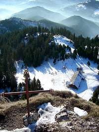 |
After this "second bottleneck", the wall will get less steep and can be climbed comfortably straight to the top. There you will find the cross, and a magnificent panorama - almost 360°. Only some higher needles of Egyeskő will close the view eastwards, and the nearby Nagy-Hagymás/Hăşmaşul Mare northwards. You will see Hargita/Harghita Mountains to the SW (in clear weather, behind them Bucsecs/Bucegi Mountains and Királykő/Piatra Craiului/Königstein will emerge in the distance), while Görgényi/Gurghiului Mountains to the W (with Kelemen/Căliman Mountains towards the NW in the distance, in clear weather). To the NE (right from Nagy-Hagymás), the nearby Csalhó/Ceahlău massif is hard to miss. Take care on the top, do not approach the edge too much - there is a vertical dropdown in all directions, except the one you came up!
 SW panorama from the foremost tower of Egyeskő SW panorama from the foremost tower of Egyeskő |
 N view from Egyeskő N view from Egyeskő |
As for trad climbing, the routes have been recently refurbished by the local climbing community. More info on www.egyesko.ro
 Northern towers of Egyeskő Northern towers of Egyeskő |
 On the foremost tower On the foremost tower |
 Eastern towers of Egyeskő Eastern towers of Egyeskő |
Accommodation and Camping
 The new hutThe former hut
SW from the rock ensemble, there is a hut (Egyeskő menedékház / Cabana Piatra Singuratică), situated at 1504 m. The original hut was built in 1932 and refurbished a few times since then, but by 2010 it had got into miserable condition. The local government decided to dismantle the old building, soon after which the construction of a new hut began.
The new building has very similar size and proportions to the old one. It offers two heated sleeping rooms and a separate dinig room. The hut is now also equipped with solar collectors to prepare warm water. Accommodation costs 20 RON/person/night.
You can also pitch a tent around the house.
Unofficial webpage: www.egyesko.ro
Red Tape
The area of Hagymás/Hăşmaş Mountains is part of the Bicaz Gorges - Hăşmaş Mountain National Park (est. in 2000). These limestone mountains are home to some rare plant (i.e.: Edelweiss, whose number has decreased considerably due to "collection" activities) and animal species.
Access is free, but the usual rules apply - respect nature. More info (regulations, tourist trail descriptions, photo gallery, etc.) can be found on the website of the NP.
Weather
Below you can find a weather forecast for Balánbánya/Bălan town by viewweather.com:When to Climb and Mountain Rescue
 Egyeskő in winter
Egyeskő can be climbed all year around, if the weather conditions allow.
Salvamont (Romanian Mountain Rescue service) has no team in the hut. The nearest Salvamont station is located at Gyilkostó/Lacu Roşu (close to Békás/Bicaz Gorge) some 13 km further north (info from the National Park webpage).
The national Salvamont dispatcher is: 0-SALVAMONT (0725-826668)
Maps
Paper maps
Giurgeu and Hăşmaş Mountains/Gyergyói-havasok és Hagymás-hegység/Munţii Giurgeu şi Hăşmaş (1:60,000) by DIMAP, with guiding text on the backside in English, Hungarian and Romanian. Can be ordered online from DIMAP here.
Online maps
A powerful free online map is being developed by the Open Maps Project for the area of Central Europe. If you are not familiar with the area or want to skip the zooming job, you can get a quick close-up view of the neighbourhood of Egyeskő/Piatra Singuratică, follow this permalink.
Miscellaneous
Language
Since this part of Romania is inhabited primarily by ethnic Hungarians, or more precisely, Seklers (székely/secui), both Hungarian and Romanian are in use. On this page I have presented geographical names in the following format: Hungarian/Romanian.
General
For further useful travel information about Romania, check out this page.
External Links
Egyeskő webpage: English version
Bicaz Gorges - Hăşmaş Mountain National Park website: English version
Balánbánya/Bălan city website
Train search: DB search engine and Romanian Railway
Driving directions: ViaMichelin
Geocaching: traditional cache by Trekking Klub Csíkszereda/Miercurea Ciuc
Videos
| Egyeskő in summer | Egyeskő in winter (from 2'50") some climbing action from 6'59" |