
-
 4968 Hits
-
 0% Score
-
 0 Votes
|
|
Route |
|---|---|
|
|
46.34314°N / 13.79368°E |
|
|
Mountaineering, Scrambling |
|
|
Summer, Fall |
|
|
Most of a day |
|
|
Walk-up |
|
|
Rating the Tour (By Hiking Standards)
0. General. A round tour from 1150 m to 2327 m, but over 7 summits (without Velika Tičarica). Mostly by marked paths, over the Vogli ridge there's no path nor marks. Easy scramble. The ascent on Velika Tičarica is on one or two places UIAA II. Gear: Good shoes, poles. If you are really an enthusiastic peak-bagger, you can ascend even 10 summits: Slatna, Kreda, Prvi Vogel, Srednji Vogel, Zadnji Vogel, Velika Zelnarica, Mala Zelnarica, Kopica, Velika Tičarica, Mala Tičarica.
1. Effort. Cca 1650 m, 10 hours.
2. Power. 1 - no difficulties, only walk-up.
3. Psyche. 2 - easy.
4. Orientation. 2 - easy.
Approach
You start this tour either on the parking place at the end of the Suha valley road, cca 1150 m, or, if you sleep there, at the hut on Planina Jezero, 1453 m (less than 1 h till there).
Route Description
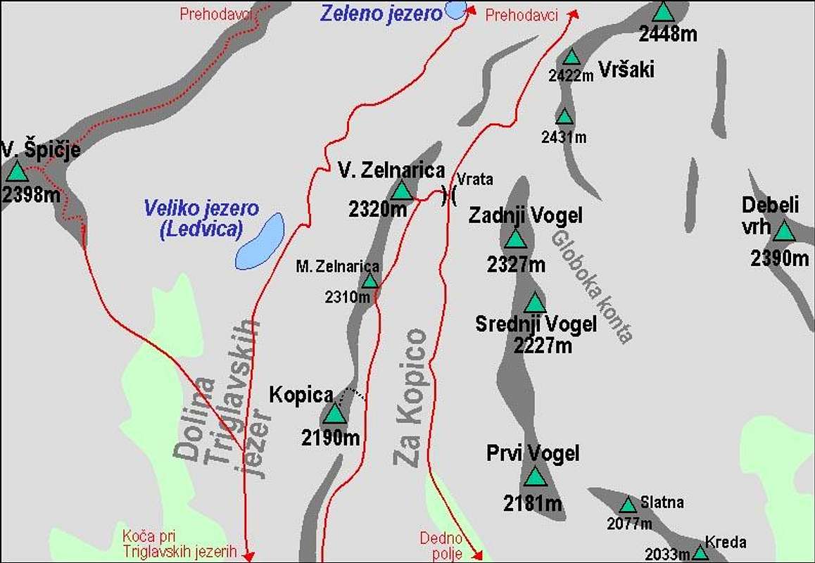
A self-made map of the area around Za Kopico
From Planina Jezero you start hiking by a well marked path towards the NW. It ascends gently through a shallow valley, called by locals 'Lorch' (=Tube). All around is an interesting karst landscape, a part of the big undulating plateau, still covered with almost untouched forrests. So, after some 30 minutes you reach out on Planina Dedno Polje (pasture), 1560 m. Here's an important crossroads.

On the pasture just continue on the NW direction. So you enter into Za Kopico valley. The first step of the valley is steeper than later on, so the path brings you in turns over it. Passing Kovačičeva glava, 1827 m you reach a basin, stretching between Mala Tičarica, Velika Tičarica, Kreda, Slatna and Prvi Vogel. Continue a few more minutes and then deter from the marked path in the northern direction (right).

The ascent on Prvi Vogel, 2181 m is not marked, but its slopes are not hard to climb. First follow the ravine between Slatna and Prvi Vogel, later go more towards the left to ascend directly to the summit. It goes everywhere, this is also a ski touring direction. The higher you get, the broader is the view, especially towards the W, S and E.
From Prvi (First) Vogel the first most beautiful part of the tour starts. A broad, rounded crest leads you towards the north. Without any difficulties you reach Srednji (Middle) Vogel, 2227 m and Zadnji (Last) Vogel, 2327 m. This is the highest point of this tour.

Descending down towards the NW to Vrata pass, 2192 m, requires choosing the best passages. Slopes can become steep if you don't find them, but when visibility is good, you should have no issues. On Vrata pass you hit again the marked path (coming up by the valley Za Kopico), but you only cross it, using the path to the top of Velika Zelnarica, 2320 m. The route goes directly up from the saddle, while the marked trail goes more towards the left, on Mala Zelnarica. Now you reached the point with today's greatest panorama!

On the summit of Velika Zelnarica (the northern one) you should find marks of the tiny path, going by the main ridge above the Valley of Triglav Lakes on the summit of Mala Zelnarica 2310 m, and furher southwards towards the summit of Kopica, 2190 m. From this path you will all the time enjoy a nice panorama.

From Kopica, you can not continue by the main ridge (15 minutes later you will see why). Return by the shoulder towards the N, descend to the marked path and follow it. You soon reach the main ridge south of Kopica, seeing its vertical walls there. Now the marked path goes southwards by the main ridge or little below it (on the E side) to the next distinctive mountain in the crest - Velika (Big) Tičarica, 2091 m. This summit can not be reached only by walking up, but also climbing is not difficult. A short eastern slope offers one or two details in the range of UIAA II.

Different is its lower neighbour - Mala (Small) Tičarica, 2071 m. Being a home-mountain of Koča pri Triglavskih jezerih (hut), it is often and easily ascended. Our path crosses its E slopes (we do another ascent of some good 50 m), then we turn right and reach the panoramic summit.
After reaching these 7 or 8 summits, the shortest way to return is towards the south, first on Ovčarija alpine meadow, 1660 m (in the middle of the descent don't go right into the Valley of Triglav Lakes) and from there towards the E on Dedno polje. The circle around Za Kopico valley is closed! Then you only descend to Planina pri jezeru and eventually further down to the parking place.