
|
|
Route |
|---|---|
|
|
38.83140°N / 104.9539°W |
|
|
Hike / Scramble with possible route finding |
|
|
Most of a day |
|
|
Class 2+ (with opportunity for Class 3) |
|
|
Quick Facts
Trailhead Elevation: 6,700'
Total Climbing: about 4,000'
Distance: 3-4 miles (one-way)
 |
got topo?
This route may require that you do your own route finding at times. The trail out of the canyon tends to disappear occasionally. The trail up to the summit can be hard to find, and once found it can be easy to lose. Be sure to bring a topo map and compass, and preferably a GPS. Be sure you're comfortable with navigation before you attempt this route.
Approach
Start at the Barr Trail. Directions to the trailhead are found in the "Getting There" section of the main page.
Start a moderate ascent on the Barr Trail. When the trail first starts, there are a few switchbacks. Then there is a relatively straight section of about one half mile. The guard rail begins for the next switchback, but there is a break in the rail, where another trail descends. Skip the switchback and descend the trail through the break in the guard rail (see photo).
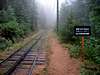
Follow this trail down to Ruxton Creek and a chain link fence. At the fence, turn right and hike along the fence. The fence and creek will be on your left. There is a decent trail here. Continue past the end of the fence. Shortly after the fence ends, you'll want to cross the creek and the train track. Crossing the creek & track in the right place is one of the keys to this route. To find your creek crossing, look for a natural bridge over the creek (the water flows under the rocks). You should be able to walk over the creek without putting your feet in the water at all. Another clue that you have reached your creek crossing is that you will see a long rectangular log (possibly an erosion bar?) at the base of 2 trees. Cross the creek.
After you cross the creek, immediately hike up out of the creek bed to the railroad bed. You will know you're in the right place because you'll see a sign along the railroad track that says "KEEP OFF TRACK. PROPERTY OF M&PPRW CO. NO TRESPASSING." To the left you may also see a purple rag tied to a tree (but who knows if it's still there). When you look down the track to the right, you'll see it curve out of sight to the right. When you look down the track to the left, you'll see it curve out of sight to the left. Your GPS will indicate 38.85054N, 104.93984W.
Cross the railroad track and scramble up the slope. You'll only have to scramble a very short distance, then you'll hit the trail that'll take you to Magog & Gog Rocks. I'll call this "Englemann Trail" for lack of a better name.
 |  |  |  |
Route Description
Having found Englemann Trail, turn right onto the trail (that's the way up). The trail parallels the railroad for a while, then, through a series of switchbacks, starts climbing up out of Englemann Canyon.
It is important to do your best to not lose this trail. If you lose the trail (which you probably will), immediately turn back to the last spot that you were on the trail, then take your time and try and figure out where the trail goes. Getting significantly off-trail will be very annoying, and may cost you quite a bit of time, as some of the canyon terrain is not easily navigable. I neglected to follow my own advice when I climbed Cameron for the second time, and got off-track and spent considerable time finding my way back on-track.
The trail makes its way to a gully where there is a stream. The trail climbs up just before this gully, and crosses the stream at about 7,500'.
At 8270', the trail abruptly stops at a huge rock formation. Scramble up to the right of the trail (Class 2+) and make your way up to the rock formation. You are now on a ridge, which I shall call "Magog Ridge."
Follow the ridge southwest, then south, toward Magog Rock. There are bits of trail that fade in and out, but in general just follow the path of least resistance. Navigation is pretty easy in this section. You'll reach Magog Rock, a huge and impressive rock formation. Scramble over the lower parts of the rock (Class 2), and continue following the ridge south. Shortly after Magog, the trail turns into a double-track (almost a dirt road).
Follow the road south, then southeast. When faced with an intersection (there will be a few), just follow the one that goes up more. Eventually you'll be on a road that goes southwest, turns south, and then turns into singletrack. The singletrack can be kind of faint but it is worth finding. If the road seems to just end with no trail in sight, take the time to search for the ribbon-marked trail (also see GPS waypoint list below).
If you managed to find the trail, follow it up. Take your time to stay on the trail. Just like down in the canyon, it's easy to lose this trail, and just like down in the canyon, it is worth your while to stay on it. The trail makes its way southwest, then turns northwest up toward the summit (see map). With some care, persistence, and patience, it will take you very close to, or even all the way to the summit. If you do lose the trail, just scramble up Cameron's southeast face until you reach the summit. You will want to avoid the northeast ridge unless you want the challenge of some Class 3 rockbands.
Note: You probably shouldn't depend on being able to follow the trail the whole way up and down. Bring a topo map and a compass, and preferably a GPS. Know how to use them. On the way down, you could easily find yourself in the southeast drainage if you're not paying attention. That will cause annoyance and time loss at a minimum.
 |  |  |  |
Essential Gear
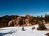
Food, water, hiking boots, and your camera. The views from Cameron Cone are wonderful. You will see a unique view of Pikes Peak, as well as views of Almagre, Mt. Rosa, Cheyenne Mountain, Garden of the Gods, and Colorado Springs.
Bring your topo map and compass. A GPS would be very useful as well.
Selected GPS Waypoints
In ascending order...
WGS 84 Map Datum
Barr Trail Cutoff (leave the Barr Trail here): 38.85279°N, 104.93865°W
Cog Railway Crossing: 38.85054°N, 104.93984°W
Gully/Stream Crossing: 38.84903°N, 104.94355°W (approx. 7,500')
Magog Ridge (trail reaches ridge here): 38.84902°N, 104.94760°W.
Last Road Intersection (follow this road/doubletrack until it turns into singletrack trail): 38.83779°N, 104.94683°W.
Trail to Summit(if you can't find the trail, follow your GPS to this location): 38.83509°N, 104.94806°W (approximately 9,300')
Ok, now I've made it really easy for you :-). (Not really)
backpakr77 - Dec 2, 2012 9:14 pm - Hasn't voted
Continuous Trail on Cameron's ConeOn 12/2/12 some friends and I climbed Cameron's Cone. After experiencing the significant route-finding that several have described, we found a much easier way to climb this peak. After crossing the creek and cog railway as described, walk downhill on the straight section of cog tracks you find yourself on. If the tracks curve, you've gone too far. If the train comes, hide. You are looking for a faint climber's trail that goes up the hill on the far side of the tracks. It is located across the tracks from another faint trail coming up from the creek, where a large log spans the creek. There are also some old railroad ties scattered about on the creek side of the tracks. IF you find this trail and stay on it through all the junctions described in the route, it is possible to hike all the way to the summit of Cameron's Cone on an unmaintained and mostly unmarked, but completely continuous trail.
rockyy3 - Mar 28, 2013 10:40 am - Hasn't voted
Finding this trailOk, I hiked up to Magog last weekend. I totally missed the trail on the way up and pretty much climbed up from due north of Magog, to Magog. From there, I took the trail back down. What I discovered, is the easy way to find this trail. Don't go right at the fence by ruxton, go left- downhill. Cross the two metal bridges you find, then go up to the COG tracks. There is a "telephone pole" (probably electric actually) on the north side of the tracks with the number 044954 on it. Enter the woods across the rail from there, and pick up the trail at its very bottom! My GPS recorded this as 38°51'7.3" and -104°56'16.7" .
dalezjc - Nov 23, 2023 5:05 am - Hasn't voted
Thanks!Tried finding this trail yesterday (Nov 22) but had no luck. I did cross the two bridges but then had no idea where to go from there. Do you have a gpx file you can share? Thanks, Dale