
|
|
Mountain/Rock |
|---|---|
|
|
39.22214°N / 120.2639°W |
|
|
Placer |
|
|
Hiking, Scrambling |
|
|
Spring, Summer, Fall |
|
|
8506 ft / 2593 m |
|
|
Overview
Entin Peak (Point 8506 on topographic maps) dominates the skyline above Olympic Valley, California adjacent to the Palisades Tahoe ski resort, formerly Squaw Valley. For years, despite being an obvious landmark, it was not officially named. But that all changed in January 2010 when it was renamed for Andrew "Drew" James Entin, 41, of Truckee, California, who died on March 3, 2009, of injuries sustained during avalanche control work at the ski resort. Entin Peak now has a much better cairn and prayer flags on the summit.
Despite being located in a mountain wilderness, the summit is located just outside the Granite Chief Wilderness boundary. Getting to this summit requires some route-finding. The Granite Chief trail can be taken for the first 2+ miles and first 1,040 feet, but the rest of the way requires some moderate bushwhacking. Fortunately, the top of Entin Peak is not far away from the trail, and the likelihood of getting lost is low.
Entin Peak has less than 200' of prominence. It deserves its own page is because it is such an obvious landmark to the tens of thousands of visitors each year to Olympic Valley. That's one reason it finally got an official name. It is located two miles south-southwest of Tinker Knob on the south end of a long ridge with numerous sub-peaks.
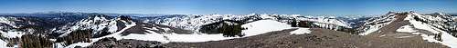
Once at the summit, you will find great views toward the Granite Chief Wilderness, including Granite Chief, Needle Peak, and Lyon Peak. There are also excellent views of Lake Tahoe, as well as views east towards Mount Rose and north towards the Castle Pass area. Finally, there are immediate views towards Tinker Knob and the mountain along the ridge between Entin Peak and Tinker Knob.
Getting There
The Entin Peak trailhead is the same starting point for Granite Chief. From Truckee or Reno, take Interstate 80 to CA State Route 89 going south for 8.5 miles to Olympic Valley Road. Follow Olympic Valley Road Westward for a couple miles until you hit the center of the village. Take a right at the sign for the Olympic Valley Inn. Follow it past the entrance to the Inn. There is a parking area on the right where there are two trailheads to use.
Route Information
There are basically two route options to Entin Peak. Both require off-trail hiking and route-finding. However, both can be done in three or four hours.
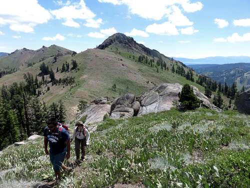
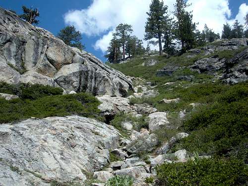
The approach starts by hiking up from the parking lot on the access trail to the Granite Chief Trail (there are a few minor access trails heading up from the right side of the hotel to the trail). Follow the trail as it heads to the left where it winds around and eventually hits a sign pointing towards the Granite Chief Trail. Follow the trail as it skirts up towards Point 8506, which is in sight only part of the way. Continue up the trail as it enters an open slope. Here there will be the first wide open views of the mountains to the west, including the tram that heads up to the Alpine Meadows ski lift area as well as Granite Chief in the distance. Continue north up the trail further until you get to a cross over point at an elevation of approximately 7300', seen in the photo below.
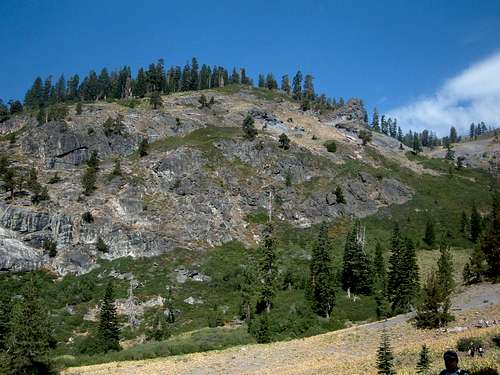 The trail continues along the rock cliffs
From here, the two route options diverge.
Route 1
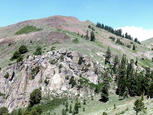
Once at the rock cliffs in the photo, turn right and head up the steep slope. Take the gully, or either side of the gully. This involves gaining more than 800' of open forest and scree slope to the ridge between Silver Peak-West Peak (to the south) and Entin Peak (to the north). The route to the ridge is very steep and can get overgrown. Be very careful on the way up. Once at the ridge, head left (north) towards Entin Peak. The ascent is steep, but not too bad, since it quickly gains elevation and has good tread. Pretty soon you will hit a large treeless meadow. The summit comes into view, with a large cairn and prayer flags.
 Heading up the steep slope to Entin Peak
 Entin Peak from above the saddle between it and Silver Peak-West Peak
 View back to Silver Peak-West Peak while heading up Entin Peak
The total distance to the summit via this route is about 3 1/4 miles. Elevation gain from the trailhead to the summit is approximately 2,350 feet.
Route 2
For the 2nd route, instead of turning right, continue up the Granite Chief Trail as it heads west below the rock cliffs. After about 1/4 mile, you will be at a point just above the cliffs. Notice on the right side of the trail is an open spot heading up the mountain side. It is shown in the photo below.
 Turn off point from the Granite Chief Trail
Head up the steep slope to the top of the ridge. It will take a good 30 minutes or so to get up there. Entin Peak is to the northeast. That might prompt you to head to the right. However, a better option is to simply stay straight. If you head too far right, you reach the edge of the mountain, and have to bushwhack. The best option to is to go as high as you can go, and then head back east towards Entin Peak. Once on top of the ridge, the route is self-explanatory. Head eastward up the open meadow to the summit.
The total distance to the summit via this route is about 3 1/2 miles. Elevation gain from the trailhead to the summit is approximately 2,300 feet.
Descent
Regardless of the route you take on the way up the mountain, it is generally safer to descend via Route 2. Be careful in route-finding, but head generally south-southwest. Do not head too far west. As long as you are losing elevation, and following the path of least resistance, you should find your way back to the Granite Chief Trail.
Another option for the descent is to include Silver Peak 8,424' via a traverse. In total, this only adds a little over a mile to the total hike. The traverse is a bit tricky, but not too difficult. Here is a trip report describing the route.
Red Tape
There is no Red Tape and no restrictions. For camping information, consult the Granite Chief page.
External Links
General information on the Granite Chief Wilderness