
|
|
Mountain/Rock |
|---|---|
|
|
38.98370°N / 120.1296°W |
|
|
9269 ft / 2825 m |
|
|
Overview
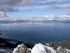
Peak 9269 is on the western ridge of Lake Tahoe. It is sandwiched between the popular Jake's Peak and Rubicon Peak. The peak is not technically difficult to climb, with the trickest section being the summit block (Class 3). There are two prominent granite blocks on the summit with the southern most being the true summit.
 |  |
Getting There
The route starts at D.L. Bliss State park. D.L. Bliss is 17 miles south of Tahoe City on highway 89. You can park your vehical at the state park or there is a turnout just north of the park entrance. From D.L. Bliss you cross 89 and start heading upwards. The route is completely off trail. You will quickly run into a creek drainage wich you can follow up towards the saddle between Jakes Peak and Peak 9269. Alternatively, you can break north below the saddle and take a more direct route up to the peak by staying on the east side of the ridge and following up the contour. The total elevation gain is approximately 2800 feet over two miles.
 |  |
Red Tape
Peak 9269 is in Desolation Wilderness so a permit is required. There are no quotas for day use, but there is a strict quota for night use and zone restrictions for where you can camp. For more info contact USFS.
When To Climb
Any time of the year is good to climb, but the winter provides easier foot traffic up through the underbrush. Note - an ice axe or crampons were NOT required but the summit block can be a bit tricky when covered with snow and ice.
 |  |