
-
 8959 Hits
-
 71.06% Score
-
 1 Votes
|
|
Route |
|---|---|
|
|
33.95530°N / 109.1242°W |
|
|
Hike |
|
|
Half a day |
|
|
Walk-up |
|
|
Approach
FR 56 is 20.5 miles south of Springerville and 5.5 miles north of Alpine on US 180/191.
Head east and follow the well signed road five miles towards Terry Flat to the Escudilla National Recreation Trail #308 trailhead.
Route Description
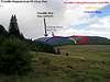
The beauty of the area more than compensates for the lack of difficulty of this hike. The hike begins at roughly 9,600 feet on the Terry Flat loop and gains roughly 1300 feet over 3.3 miles. Most of the hike follows an old supply road 2.7 miles to the highest fire lookout tower in Arizona. The Escudilla Wilderness area begins near the trailhead as the route passes up through dense stands of aspen that have flourished since a fire in 1953 ravaged the conifers standing then. Approximately 0.8 miles in conifers start to intermix with aspens and the first meadows appear. The trail continues to climb up to Profanity ridge with Toolbox draw on your left. The trail tops Profanity Ridge (~10,590) after 1.4 miles as the forest becomes primarily fir and spruce. After a short descent of the north side of Profanity ridge, the trail opens up to a meadow with a signed junction with the Government Trail #119 at 1.61 miles from the trailhead. The trail climbs north through the meadow re-entering the conifer forest at around 10,600 feet before winding to the northwest and terminating at the fire lookout tower (2.73 miles from trailhead). The lookout tower is actually at an elevation of 10,877 feet. The true high point of Escudilla Mountain is 0.6 miles to the north at an elevation of 10,912 feet. Cross-country travel is necessary to reach the 4 foot rock cairn at the true summit of Escudilla Mountain. The conifers at the summit block the beautiful vistas that are available from the lookout tower.
 |  |  |  |
Essential Gear
Typical hiking equipment. Be prepared for inclement weather any time of year. A GPS, map, & compass will be useful in finding the true summit from the lookout tower.
Miscellaneous Info
If you have information about this route that doesn't pertain to any of the other sections, please add it here.