
|
|
Route |
|---|---|
|
|
46.80000°N / 8.45847°E |
|
|
Via Ferrata |
|
|
Summer, Fall |
|
|
Half a day |
|
|
Class 4 |
|
|
K4 |
|
|
Overview
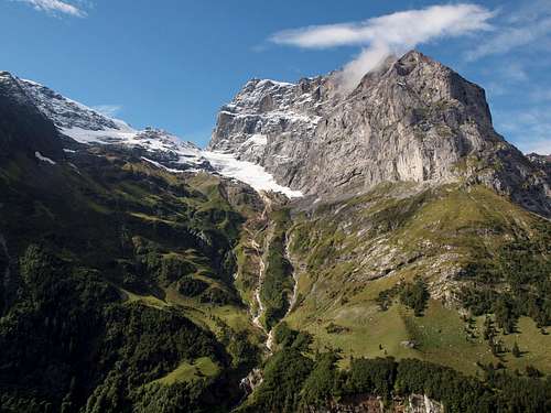

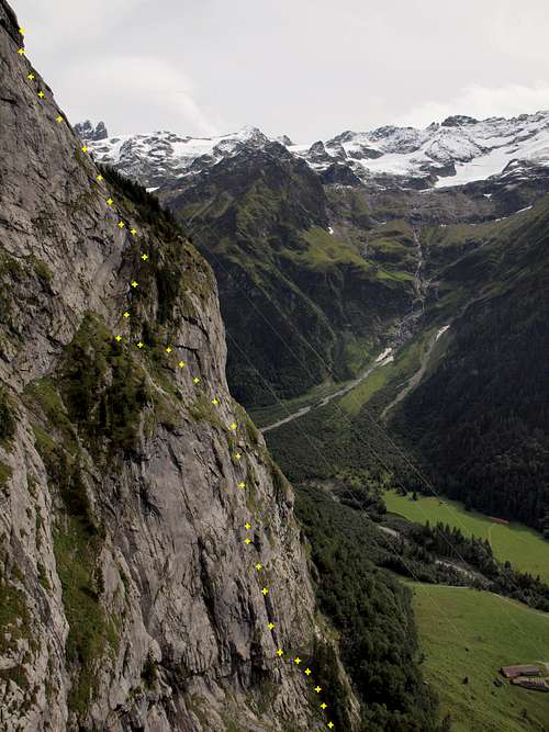
Fürenwand is a nice via ferrata in the grade K4 (scale from 1=easy to 5=very difficult) that rises 760 meters (climbing altitude) to the south of Engelberg in the Urner Alps (according to SOIUSA an undersection of the Bernese Alps).
There are some overhanging ladders, the last ladder before the exit of the route is long, overhanging and very airy.
The face is vertical and very steep. It is divided by a gras-band (the so called Jägerband) located at two thirds of total altitude gain.
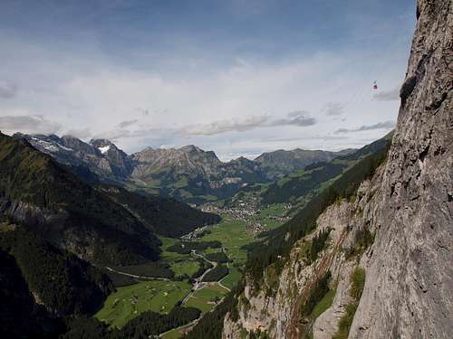
The route offers great views to the surrounding mountains (Titlis, Gross + Chli Spannort, Schloßberg) and into the Engelberg valley.
Total time is between 2 and 4 hours depending on personal fitness, traffic in the route or the speed one wants to go for.
A cablecar can be used returning down.
Getting There

Base is the town of Engelberg, that can be reached by car or railway.
Route Description
Until now the very steep, high Fürenwand was a technically very difficult climb. The steep, exposed via ferrata now offers an entirely new vertical experience. A route that has become a classic. Not for beginners.
Departure Point
Valley station of Fürenalp cableway.
Trailhead
Starting at the valley station of the Fürenalp cableway follow the road in the direction of Herrenrüti. At approx. 1,140 m a signpost points left (Klettersteig-Fürenwand); continue on the blue-white-blue marked trail. The trail markings lead you on a zigzag route to the trailhead at the foot of the mighty Fürenhochflue (1,240 m sign). Following a cable, the climb leads to the right under a steep cleft. More steep climbs over smooth ridges provide the high, as the view downwards becomes more and more majestic and the hikers on the Herrenrüti appear smaller and smaller. After the first rock face (250m high), you arrive at a grassy hunters' ledge. Following the cables, you get a majestic view of the upper part of the rock wall. At the end of the hunters' ledge iron footholds lead you back to the rock face. Exiting the Fürenwand requires some effort! Trail markers lead you via Hundschuft meadow (1,840 m) to the Fürenalp mountain restaurant.
Descent
Via Fürenalp cable car. Various marked hiking paths take you via Äbnet (cable car), Stäuber-Stäfeli-Alpenrösli or via Dagenstal back to the valley station of the Fürenalp cableway.
Overnight accommodation
Fürenalp mountain restaurant 1,840 m, Tel. +41 41 637 39 49
Season
End of May to mid-October.
Waypoints
Please see the following link for GPS waypoints: http://www.gpsies.com/map.do?fileId=aibfldufiwjetwrd&referrer=trackList
Essential Gear

Weather forecast

Additional external Links
http://www.myswitzerland.com/de-de/fuerenwand-die-meisterpruefung-gegenueber-dem-titlis.html (Information is multilanguage)http://www.fuerenalp.ch/klettersteig (Information in German and English)
http://www.fuerenalp.ch/ (Information in German and English)
http://www.fuerenalp.ch/assets/Dateien/Files/PDF/Engelberg_Fuerenalp_Klettersteig.pdf (only in German)
http://www.engelberg.ch/aktivitaeten/sommer/klettersteige/fuerenwand/ (Information in German and English)