
-
 9917 Hits
-
 73.06% Score
-
 3 Votes
|
|
Trailhead |
|---|---|
|
|
48.27737°N / 113.4379°W |
|
|
Flathead |
|
|
Spring, Summer, Fall, Winter |
|
|
4689 ft / 1429 m |
Directions To The Trailhead:
 Trail Access Sign
This trailhead is located in southern section of Glacier National Park just southwest of Marias Pass on U.S. Highway 2.
To locate the correct road travel either from east or west to mile marker 192. This mileage marker is located just east of the bridge that crosses a point near the confluence of Bear Creek and Geifer Creek.
If traveling from East Glacier, Montana:
Drive over Marias Pass and travel past mile marker 193 be ready to turn right at mile marker 192 before crossing the bridge.
If traveling from West Glacier, Montana:
Drive east from west Glacier, Montana to mile marker 192. Turn left after crossing the Bear Creek Bridge.
After turning on to the usually well graded gravel road travel about 1 mile to the Parking area for the Fielding Access Road Trailhead.
The sign designating the trail head is on the right side and is near a locked gate. Please do not block the gate. This road serves as an access road for the BNSF railroad and you may be in for an unpleasant experience if they have to move your vehicle.
There is ample parking just beyond the trailhead sign.
Accessing The Trails:
 Transition to forest road
 Approaching the Railroad Grade
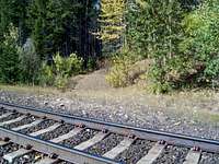 Trail begins
Trails accessed from the Fielding Access Road Trailhead include: Elk Mountain Overlook Trail, Fielding-Coal Creek Trail and the Ole Creek Trail.
Access to Glacier National Park from this trailhead is allowed by the private landowners that own the land on BOTH side of the dirt road that leads to the park access.
Please respect this land and do not travel off the established road. It would be a shame to loose access to this remarkable area as a result of persons not respecting the rights of the landowners.
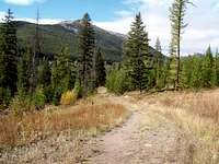
The trail starts out near the parking area at the trailhead. After a few hundred feet the trail joins a forest road. Continue up hill for about .75 miles to the location where the forest road meets the railroad grade. Cross over both sets of tracks and look slightly to the left for the trail that takes off into the park.
There is a trail sign there indicting distances to:
Ole Creek Campground (2.5 miles)
Park Creek Campground (7.3 miles)
Walton Ranger Station (10.2 miles)
Ole Lake (12.7 miles)
About one half mile from the trail sign, The Fielding Patrol Cabin can be found. The trail to Elk Mountain is just beyond the cabin. From that sign it is 2.5 miles to the summit of Elk Mountain.